


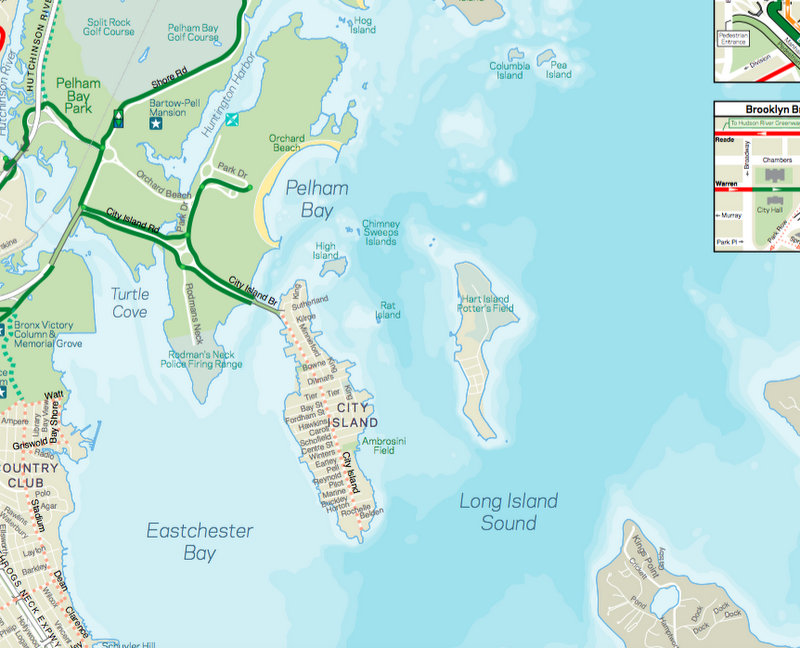
8. Hart Island Does Not Appear on MTA Maps
 Hart Island is just to the east of City Island, but is not drawn on the MTA maps
The MTA subway and bus maps are known to leave out or exaggerate details for clarity, and Hart Island is certainly one of those details. Unlike Rikers Island, which is alternatively labeled and unlabeled depending on the version of the map, Hart Island is not even drawn on the map. Similarly, Hart Island did not appear as any kind of land mass in the Department of Transportation Bicycle Maps until 2012, where it was labeled “Hart Island Potter’s Field.” But starting in 2015, half of Hart Island was covered over by zoomed in maps of other neighborhoods.
 2011 NYC DOT Bike Map, missing Hart Island
 2013 and 2014 NYC DOT Bike Maps, showing Hart Island
 2015 and 2016 NYC DOT Bike Maps, Hart Island is cut off
Even historically, the 1906 IRT subway map, which was much more detailed than later maps, cuts off just after City Island (although the map is fun, because you’ll see the shoreline of the Bronx prior to the infill that became Orchard Beach.