The following article is a special report to Untapped Cities by Frederick “Fritz” Steiner, the Dean of the University of Texas at Austin School of Architecture.
I had the privilege of traveling to Ecuador from May 24-June 6, 2011, visiting the capital of Quito, the mountain provinces, and the Galápagos Islands. I wrote a journal of my experiences and would like to share some of the amazing history and culture of the highlands region.
San Francisco de Quito rests in a nest of volcanoes high in the Andes Mountains. At 2,850 meters (9,321 feet) above sea level, the city traces its origins back to 1500 BC. Early settlers were the Quitus of the Quechua civilization who integrated with the coastal Caras giving rise to the Shyris. The conquering Incas lived here for a brief, but important, 47 years creating an important city which they razed before the arrival of the Spanish conquistadors. Lieutenant Sabastián de Benalcázar founded the current city in 1534 atop the ashes of the Inca settlement. Its original name was Kito, meaning “middle of earth.”
Between 1736 and 1744, a geodesic expedition from the French L’Académie des Sciences confirmed what the native people knew: a valley near Quito is indeed at the center of the world with the latitude of 00à”¹à… ¡ 00’ 00.” Every day this equatorial city, widely known by its shorter name, Quito, has 12 hours of light and 12 hours of darkness.
The Spanish laid their grid on top of that of the Inca. This north-south/east-west street system persists to the present day in the historic center of the city. The major north-south Inca royal road is today called both Calle Garciá Moreno and La Calle de las Siete Cruces. The crosses of seven Catholic churches rise from what were prominent Inca royal sites. The presidential palace, the main cathedral, and Plaza Grande are also located along Garciá Moreno/Siete Cruces and attract political demonstrations, concerts, and various civic activities. At midday, the streets of the old town fill with children in school uniforms, bureaucrats and businessmen in suits, shoe shine boys, tourists, policemen, pickpockets, and Indian women selling tangerines, avocadoes, and pears.
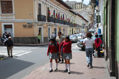
Historic center of Quito, Ecuador. Photo by Fritz Steiner.
Garciá Moreno/Siete Cruces points toward the volcanic hill El Panecillo with the 45-meter/148-foot-tall statue La Virgin de Quito on top. One’s eyes burn from the pollution caused by cars, trucks, and buses. In the late 20th century, poorly designed, modern buildings were inserted into the urban fabric with no regard to scale, materials, or context. Several, once grand houses of the elite have been restored as banks and hotels, but others appear to be in various stages of abandonment or disrepair. Its 1978 UNESCO World Heritage status has not protected this historic and beautiful district from the ravishing consequences of time.
Cotopaxi Province lies south of Quito along what Alexander von Humboldt called “the Avenue of the Volcanoes.” Today, the Pan-American Highway runs through the Machachi Valley. The road cuts display layers of volcanic ash flows. Small villages dot the landscape. Wherever a small, village church rises above other village structures, there once was an Indian shrine. As the large colonial haciendas were broken up through various land reforms, the resulting small plots reveal a hardscrabble existence for the peasant who once worked the estates but now has too little land or know-how to prosper.
In the Thursday markets of Saquisili, the Panzaleo people sell hogs and cattle, chickens and guinea pigs, llama and goats, fruits and vegetables, Panama hats and ponchos, carpets and colorful rope, and handbags and masks. The people are outgoing and friendly. While especially the women retain their colorful, distinctive dress, including felt hats, there is scant native or even colonial architecture beyond the street grid, main plazas, and churches. Some haciendas remain, with several prominent ones converted to restaurants and hotels.
The Spanish built an Augustinian monastery on a former Inca palace (or temple) site to manufacture textiles and to convert the native people to Christianity. A prominent Ecuadorian family, the Plazas, in turn purchased Hacienda San Agustin de Callo in 1921. The Plaza family included the leader of the liberal revolution, General Leonidas Plaza Gutierrez, who was twice elected president (in 1901 and 1912). His son, Galo Plaza, was also president in 1948. The hacienda remains in the ownership of the Plaza family. Around its courtyard, visitors can dine and sleep within the stones first carved and placed by the Incas. In addition to the Inca walls, the hacienda also exhibits Spanish Colonial and Ecuadorian Republican construction. Thick potato soup, locra da papa, connects the present-day traveler to what has grown in the earth of the Andes for generations.
 Fruits from the Market in Saquisili, Equador
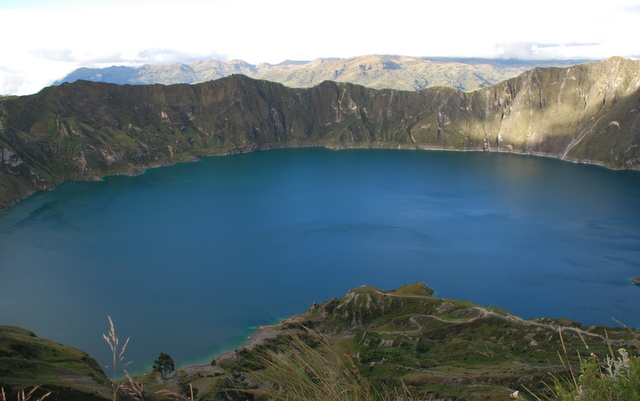
The water-filled Quilotoa caldera (3,914 meters/12,841 feet, above sea level) is nestled in the western Andes bordering the Machachi Valley. Local families control access to views of the greenish, deep lake 400 meters/1,312 feet below the rim of the crater. The hamlet of Quilotoa includes a handful of hostels, restaurants, and homes. A few grass roots represent the remnants of indigenous buildings.
An idiosyncratic group of artists live at Quilotoa and in Comunidad Tigua. These artists paint bright scenes of Andean life and landscapes on sheepskins. Their style of painting evolved from the decoration of drums. The colorful paintings combine traditional and Catholic legends with everyday activities, such as growing potatoes and herding llamas, with contemporary politics sprinkled in some depictions.
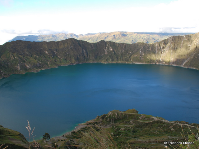 The water-filled Quilotoa caldera, Ecuador
Located near Cotopaxi Volcano, La Ciénega is one of Ecuador’s oldest colonial haciendas, established in 1695. A magnificent allée of eucalyptus lines the entrance to the hacienda. While now a hotel, its prominent owner family hosted many luminaries in the past, including Humboldt in 1802 and Charles-Marie de La Condamine, one of the French scientists involved in the 18th century geodesic mission. The main house, the lush courtyard, and delightful small chapel remain in superb condition. The integrity of the surrounding agricultural and other support buildings as well as the adjacent landscape is more ragged.
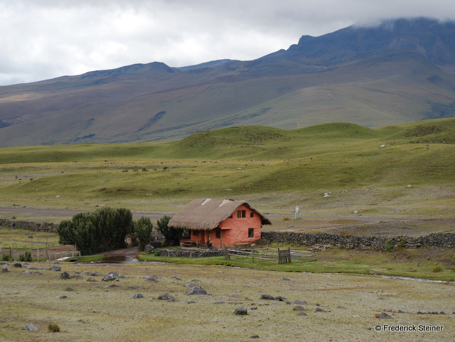 Tambopaxi hiking outfitting lodge in Cotopaxi National Park, Ecuador
The 33,393-hectare (82,516-acre) Cotopaxi National Park that surrounds the world’s most continuously active volcano (5,897 meters/19,348 feet above sea level) includes a mixture of public and private lands. Many pine trees have been planted on the private lands to attempt to control erosion and to generate some income, with deleterious consequences for the native ecosystem. A park road ropes up the slope of the volcano to 4,600 meters/15,092 feet above sea level with changes in climate, flora, and fauna along the climb. As the temperature cools and becomes mistier, the plants and animals are scarcer among the stark basalt terrain. At lower elevations, herds of wild horses have adapted to the high-altitude grasslands.
Past Calderón (“the gateway” ), the Pan-American Highway north of Quito follows an Inca road and traverses rich farm fields and many flower plantations. The markets of Otavalo (2,550 meters/8,366 feet above sea level) in Imbabura Province provide the destination for many, especially on Saturday. Nearby, the village of Peguche specializes in weaving and Cotacachi in leather goods. The Otavaleà±os have prospered through their markets. Women wear white blouses, long skirts, head cloths, and strands of golden beads. Men don felt hats and blue ponchos. Spanish colonial architecture and town planning again are evident in the main churches and plazas.
 Spices at the market in Otavalo, Equador. Photo by Fritz Steiner.
Volcanic peaks frame the fecund, high valleys of Ecuador, ever-present reminders of the power of nature. The strength of geology dwarfs the fragility of people, as is evident in the uneven quality of the settlements of Quito and its surroundings. While the built environment contains patches of beauty, overall, human settlements in the Andes of Ecuador lack the grandeur of their natural surroundings. A challenge is to create cities and regions with the imagination of Tigua paintings, the good taste of locra da papa, the whimsy of felt hats, and the overall skill of the weavings of the Otavaleà±os.
