NYC’s Forgotten ‘War on Christmas Trees’
Discover how an obscure holiday crackdown affects festive street vendors today!


On March 7, 2012 New York City became the first local government to pass legislation ensuring public access to government data – a high-water mark, some might argue, in the open data movement. Nowhere is the impact of this trend more apparent than in cities. As people begin to sort through and make sense of all this data, government decision-making is coming under increasing scrutiny as savvy citizen groups and organizations create stronger and stronger cases to challenge the status quo.
Ahead of this curve is Gehl Architects, the Danish urban planning consultancy and design firm that helped produce the World Class Streets document which laid the ground work for the NYC DOT’s remarkable transformation of Broadway–most notably the pedestrianization of Times Square and Herald Square. For decades Gehl Architects co-founder Professor Jan Gehl has been collecting human-centric data on public spaces and public life to inform city planning practices.
Gehl Architects builds on Jan’s data collection methodologies to gather information that enforces a people-first paradigm through both design and education. With newly available numbers now quantifying the quality-of-life improvements their projects have helped produced, the Open Data movement is in many ways just beginning to catch up to Gehl’s pioneering moves.
As Gehl Architects told Untapped:
“Through the selective collection and presentation of data around human physiology and behavior correlated with the usage patterns of different city streets and public spaces we have demonstrated the direct relationship between city design and life in cities. Observations and data collected from across the world suggests that many aspects of the relationship between urban form and public life are dependent on fundamental aspects of the human experience— such as our senses, our height and way we soak in our surroundings at the speed in which we walk . These universal aspects can then be combined with the unique and contextually driven characteristics of place to create a more humanized city with healthy public life and mobility. Strategies to these ends we have been deploying around the world for the last 12 years. ”
Untapped Cities is pleased to announce its partnership with Gehl Architects for a series of collaborative posts on how data is reshaping the way cities are designed. With decades of planning and dozens of different interventions under their belt, Gehl Architects brings a wealth of international experience on how to make people the main driver in urban design. Untapped writers will be pairing these lessons with new processes, platforms and publications coming out of New York City’s budding open data movement.
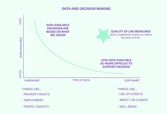
In this series of blog posts, Gehl Architects‘ Institute department and Untapped will interrogate the way in which we produce and use data on cities (as in spatially specific data). We will explore how data collection and selection influences city leaders’ decisions, and how it is often the data that is hardest to collect, that counts the most for our quality of life. This data is therefore often the most neglected in city decision making.

From a lens of people centered planning, these posts will track a course from the pioneers of data collection in cities through to tomorrow’s outlook. We will begin, as many urban geography courses do, with Charles Booth’s 1889 poverty map of London, compared and contrasted with the crowd-sourced mapping tools from Open Plans. The series will continue with an interview with Birgitte Svarre, Jan Gehl’s co-author on an up-coming book on people oriented data collection followed by an exploration on how we can use data to compare and contrast life in cities. We will take a critical look at livability in Melbourne and how data will shape urban design practice in the coming years, using the remarkable public engagement effort in Christchurch following the devastating earth quake there one year ago as an example.
Throughout, we will continually highlight how decisions around how we collect and map data on the city affects actual built results and how city design today begins with data. Whether we are aware of it or not, data drives change in our cities.
Follow Untapped Cities on Twitter and Facebook. Get in touch with the authors @untappedmich, @jakeschabas, @untappedalley. Follow Gehl Architects on Twitter @CitiesforPeople.
Subscribe to our newsletter