


As part of the Municipal Art Society Road to Resilience conference, site visits to Hurricane Sandy relief areas took place around New York City this past Friday. As part of our partnership with the conference, Untapped New York reporters headed to Red Hook, Coney Island, Staten Island, Lower Manhattan and the Lower East Side to learn more about current efforts and future needs.
Coney Island
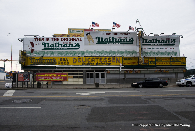
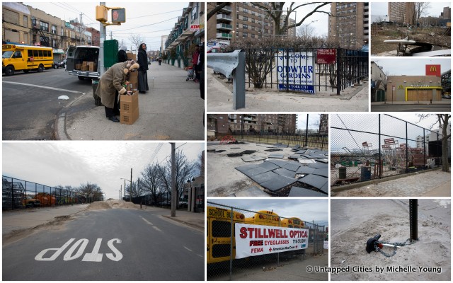
In Coney Island, the signs of Sandy were everywhere. Walking down Surf Avenue, there were, of course, boarded up stores and reopening signs. The iconic Nathan’s Famous Hotdogs was even closed. But mostly, you got the strange sensation that while things were starting to function again, many things were just slightly out of place””the piles of sand on a dead-end street, the incessant sound of construction, blown over signs ignored due to more pressing concerns, uprooted playgrounds and community gardens.
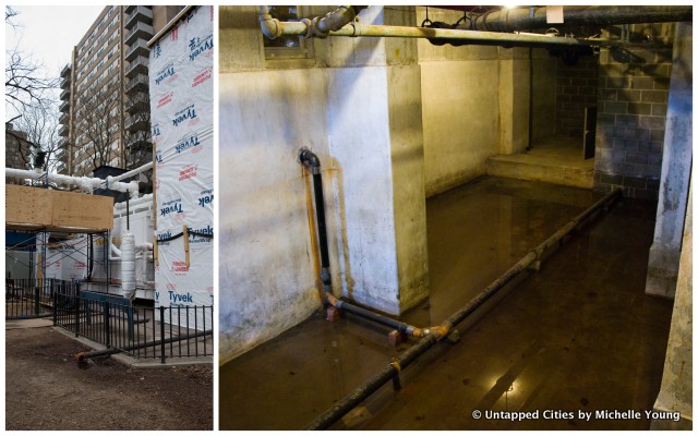
We were visiting the New York City Housing Authority (NYCHA) buildings on Coney Island. The agency spoke candidly about the work during and after the storm, emphasizing the face-to-face connections that worked when technology did not, the partnership between building managers and the Family Service Department to reach at-risk populations, and the de-facto transformation of community centers into relief centers.
The Rockaways
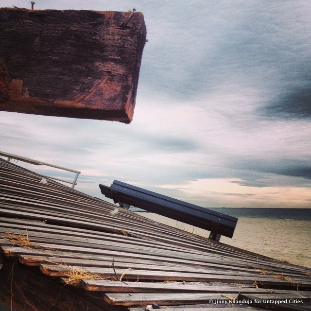
The geographical position of the Rockaways exposes this narrow strip of land to the whims and fancies of the ocean, a fact that hit home severely for its 130,000 residents in the wake of Hurricane Sandy. On last week’s tour, Jeanne Dupont of the Rockaway Waterfront Alliance and Walter Meyer of Local Office Landscape Architecture gave an informative bus and walking tour of the peninsula. The tour covered a lot of ground, from the NYCHA housing of Far Rockaway, to the beachside bungalows and surfer community of Arverne and Rockaway Beach, and finally, to the upscale single family homes of Belle Harbor and Breezy Point, where arguably the worst devastation occurred.
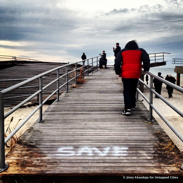
In a part of New York City already isolated by natural forces, the residents of the Rockaways were resourceful in the aftermath of Sandy. We witnessed food shelters in local community gardens, community rebuilding centers where residents could go to get advice or materials, stories of trade and barter for gasoline and other goods, and, recently, the use of DIY solar panels to bring back power to an entire commercial street still off the grid.
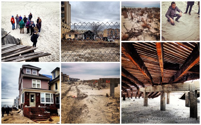
The tour also focused a great deal on landscaping and ecological features that protected the Rockaways from the worst of Sandy’s devastation. Tour leaders discussed the protective potential of sand dunes and ridges fronting the beach and boardwalk, as well as vegetation such as black locusts, dune grass, and other local species. The use of jetties on the beach, as well as alternatives such as geotube sandbags and adaptive sand transfer stations, was also discussed. Smart incorporation of new technologies and processes could help to protect against certain storm-related forces. [by Jinny Khanduja]
Red Hook
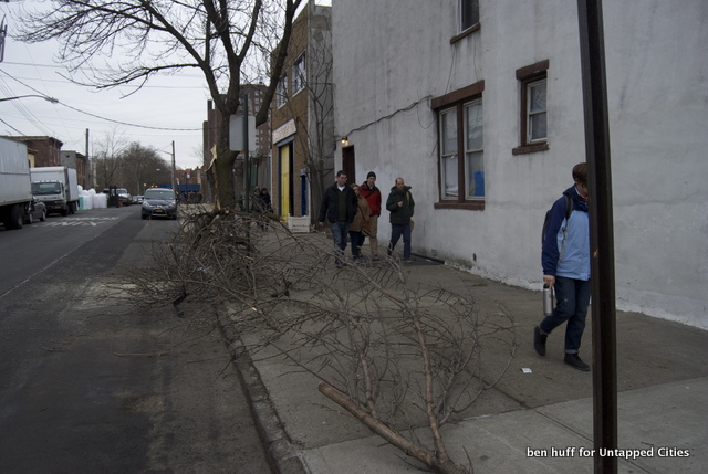
Red Hook suffered significant flooding and power outages from Hurricane Sandy. During the tour, The Red Hook Initiative (RHI) discussed the role they played in the recovery in the days after Sandy. RHI normally works to provide social services to members of the community, including job training, after school programs, and health education to a community with significant socioeconomic challenges. When Sandy hit, the RHI stepped up to the task and went after providing assistance to the community for storm damage.
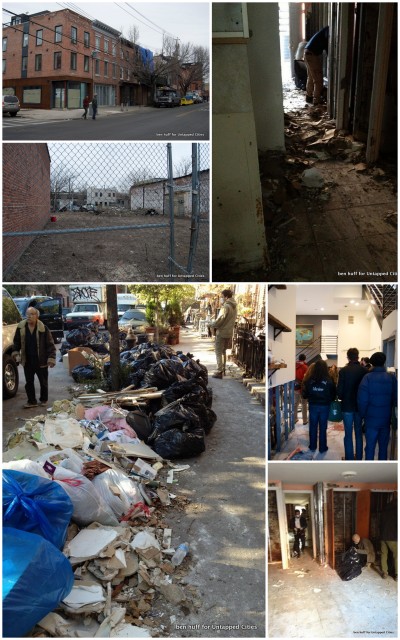
Although they didn’t have resources to deal with the loss of grocery stores and power, RHI leveraged social media to help educate citizens across New York City about what Red Hook needed and where they could deliver it. RHI had already attempted an effort to provide free wifi at their headquarters, and they used this still functioning internet to use platforms like Twitter and Facebook to request aid. From there they were able to organize volunteers and aid as it came in. When FEMA arrived, it combined its resources with RHI, which was already distributing hot meals, cleaning supplies and physical labor. I volunteered myself in Red Hook after the storm, and I found them to be able to quickly put me to work cleaning up resident basements. RHI’s work was imperative during the storm, and as Red Hook’s power is restored and homes are reoccupied, RHI is returning to its mission of providing services and job training, lifting up a community which needs it now more than ever. [by Ben Huff]
Hudson River Park
Hudson River Park was uniquely designed both in terms of its structure and its horticulture to handle flooding. Unfortunately, Hurricane
Sandy exceeded expectations, surpassing the park’s 500 year flood model. The tour surveyed storm damage and discussed the park’s recovery efforts. [by Lisa Blake]
Brooklyn Bridge Park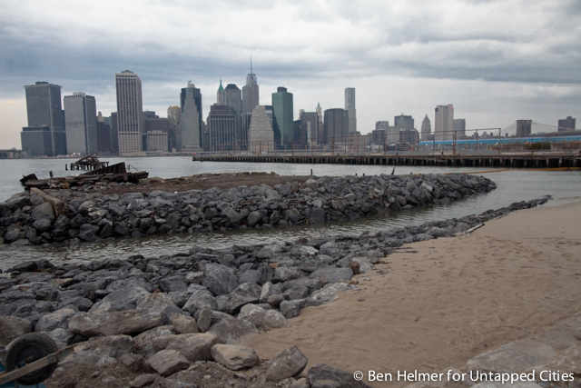
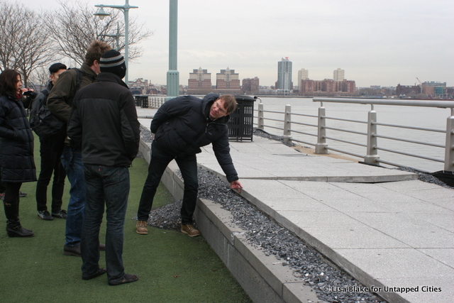
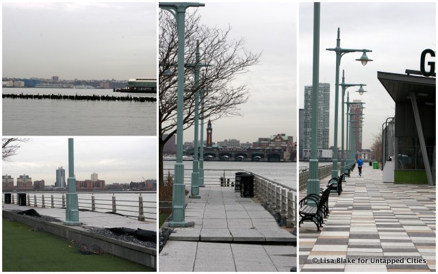
The email noted in bold: Site visits proceed rain or shine. Dress appropriately. I did my best to listen and bundled up in jeans,turtleneck, wool coat, hat, scarf and gloves. Our tour guide, Matthew Urbanski, along with his firm, Michael Van Valkenburgh Associates, were the landscape architects responsible for the design of Brooklyn Bridge Park. The park, which opened in 2010, only had minor destruction from Hurricane Sandy, namely damage to their electrical system, which is still under repair, and damage to two of their playground surfaces.
What the park did get to do was watch and see how their design elements withstood the unexpected crisis caused by Mother Nature. The Brooklyn Bridge Park weathered the storm because of three key components: they raised the level of the topography eight feet; they created a special soil mixture that incorporated a high sand content which allowed for excellent drainage; and after lengthy reviews of other nearby watershed areas, they chose the right species to hold up
against both salt and water levels.
Park plans include several new developments including more residential and commercial sites, an outdoor activity area located on Pier 2 and more park areas. The developers and the architects plan to continue pushing the BBP to come up with even more effective flood prevention measures. I’m sure we’ll be keeping an eye on what they do so we can better learn from experience. [by Larissa Zimberoff]
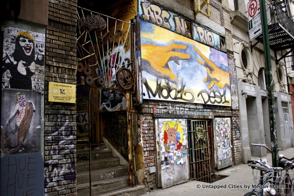
Lower East Side
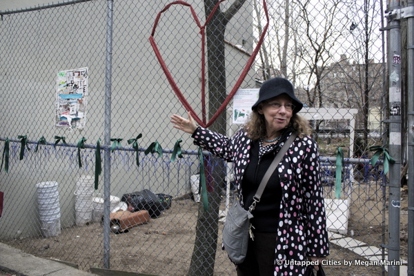
Led by Green Map NYC, the adapting to change in the Lower East Side tour visited a number of sites that confront climate change through resilient infrastructure. Among these sites were community gardens, buildings, and park spaces that provide both green and social infrastructure.
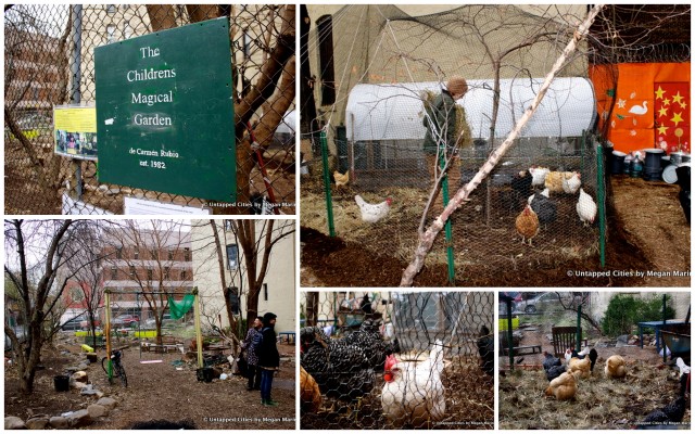
A strong narrative surfaced throughout the tour about a community that was born out of the disaster response in the Lower East Side and cultivated by these shared spaces. A community garden that houses chickens from Governor’s Island facilitated interactions between neighbors, who pitch in to tend the chicken coop and gardens in exchange for eggs. A shared interest in forward thinking and responsive building technologies facilitated conversations and connected people who take importance in improving their neighborhood and, more broadly in creating a more resilient New York. What these stories illustrated was that although the discussion tends to center around physical strategies to respond to climate change, social resiliency is an often times unrecognized yet essential component to be considered in the effort to make our city a more resilient place to live. [by Megan Marini]
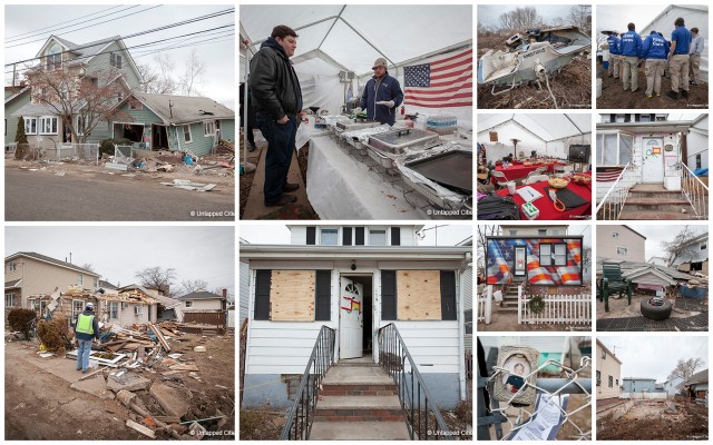
Hurricane Sandy Relief on Staten Island
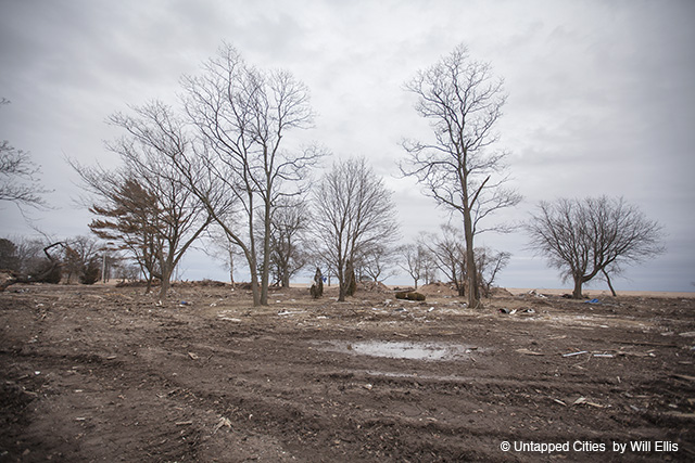
In a previous article, AbandonedNYC photographer Will Ellis wrote of the continuing Hurricane Sandy relief efforts on Staten Island. Only two houses still stand on devastated Cedar Grove Beach, many are still living in shelters, hotels or with family, while recovery centers and FEMA are fixtures on the scene. Ellis Writes:
Eleven weeks after Hurricane Sandy, much of New York City has reassumed a state of normalcy, but as the headlines fade some victims are still taking their first halting steps toward recovery, settling in for the long road ahead. That’s the case in post-Sandy Staten Island. Neighborhoods like Cedar Grove, a close-knit beachside community of working-class families, took on 12 ft. of water as the superstorm raged against Staten Island’s south shore.
Here, the shadow of the storm emerges in unexpected moments. On a crowded bus, phrases like “You’re a hero” and “We were wiped out” are spoken without a shred of irony. On the sidewalk, conversation fluctuates between anger and hope, laughter and tears. Neighborhoods have been transformed, but not destroyed; living in the “forgotten borough,” Staten Islanders are known for their self-reliance. Still, organizers feel that the government has left them behind following last week’s decision to pass only a small portion of a Sandy relief bill.
Read on for additional photos and information on Hurricane Sandy relief in Staten Island.