

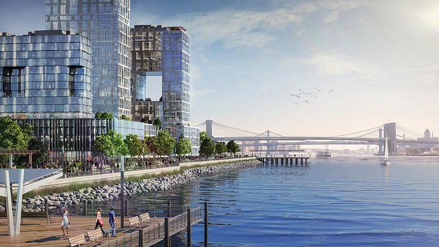
Rendering for Seaport City, a new neighborhood in lower Manhattan that will protect against storm surge via NYC.gov
The opening page to NYC Gov’s “A Stronger, More Resilient New York” defines resilient as
“1. Able to bounce back after change or adversity 2. Capable of preparing for, responding to, and recovering from difficult situations.” It then provides synonyms: “Tough. See also: New York City.”
Released seven months after Hurricane Sandy, the strategy paper was the end result of the Special Initiative for Rebuilding and Resiliency. It cited examples of waterfront developments like Battery Park City and Rockaway’s Arverne by the Sea, that successfully survived Sandy through built-in measures, leading to the bold claim: “We can embrace our coastline.” With this is a call to bring back the coastline as a protective barrier, as it once served during New Amsterdam.
The city favors an “integrated system of discrete coastal projects, that together would constitute the elements of a multilayered approach.” Such an approach, it is believed, would limit a catastrophic collapse as in New Orleans during Hurricane Katrina when the levees failed. The city is considering bolstering both historic natural features and new technologies, rather than a single “silver bullet” solution, such as harborwide storm surge barriers. Such barriers have a high cost ($20-$25 billion), take 2 to 3 decades to design and build, and would have hydrodynamic and environmental impacts.
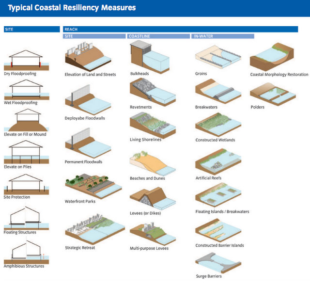
Coastal Resiliency Measures. Source: NYC.gov
In addition to coastal protection like armor stone shorelines, tidal gates, deployable flood walls, the larger scale built initiatives in the plan include the installation of wetlands off Howard Beach and a multi-purpose levee near South Street Seaport that would address flooding while creating economic opportunities. The levee/neighborhood, dubbed “Seaport City,” would be located in one of the lowest lying areas of southern Manhattan from the Battery Maritime Building to Pier 35. It would provide land for commercial and residential building construction, serving “much of the same function as Battery Park City does along the Hudson River.” The study for this development would also look to re-imagine the FDR Drive and to coordinate with the 2nd Avenue Subway construction.
The document acknowledges that this development would be a major change to the waterfront, aesthetically and ecologically and required additional study by the EDC this year. On July 31st, the EDC issued a request for proposals “to advance the next stages of technical planning for the levee system and related development of Seaport City.” The proposals, due on August 22nd, will address the technical, financial, environmental and legal feasibility of the potential development.
Read more projects in the works for NYC’s waterways. Get in touch with the author @untappedmich.