Spot a Ghost Sign for NYC's Lost Automat
There are no more Horn & Hardarts in NYC, but remnants of them still exist!


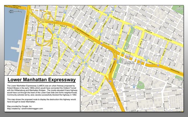
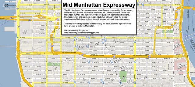
Yesterday we published a piece in “honor” of Robert Moses’ birthday on 5 things in NYC we can blame on him. In our research, we came across these amazing maps by Andrew Lynch that show what New York might have looked like if some of his plans were built, like the Lower Manhattan Expressway (LOMEX) and the Mid-Manhattan Expressway.

LOMEX is of course the most well-known because it would have razed 14 blocks of Soho and Little Italy. The Mid Manhattan Expressway would have cut through the area that was hotly debated this year in the East Midtown Rezoning. Had the expressway been built, the city would have been having a much different conversation about Midtown East.
Andrew Lynch, who made the maps, surmises that the act of mapmaking may have seduced Robert Moses:
“[It] let him think that a line across the map represented far less chaos and destruction than he perceived. Adjusting lines on a map is easy and because a map is a visual design, adjusting lines seems like a good way to clean up the map. But the lines on a map hide the fact that they represent something real, a street that needs to be moved, houses that need to be knocked down, families and businesses that need to be kicked out.”
But don’t worry, we’re aware that Robert Moses has positive legacies as well, like Lincoln Center, Jones Beach, Riverside Park. We promise we’ll do one next year on the things we can thank him for, which our readers kindly also reminded us of.
Get in touch with the author @untappedmich. See more maps in our Fun Maps Column. See more from Lynch’s website, Vanshnookenragen.
Subscribe to our newsletter