NYC’s Forgotten ‘War on Christmas Trees’
Discover how an obscure holiday crackdown affects festive street vendors today!


While subtle and quiet against the the Ed Koch Queensboro Bridge, the Roosevelt Island Tramway is nonetheless a staple of the East Side skyline. Currently, you can catch the tram in Manhattan by walking a short distance from the Lexington Avenue / 59th Street subway station. But what if the trams weren’t confined to the East side? What if they extended further into Manhattan?
The Forum For Urban Design has spent ample time speculating about New York City infrastructure and how it might be improved. Last spring, the Forum asked designers and civic leaders to pitch their—however impractical—ideas for building a better New York.
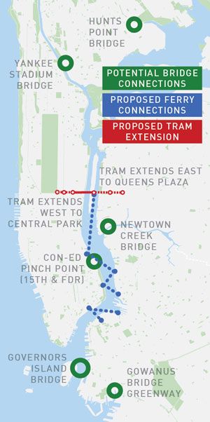
One suggestion included an expansion of the Roosevelt Island Tramway, and the simulated image is undoubtedly intriguing. In this conjecture, the tram would span from Queens Plaza to Central Park. It would serve not only as an alternate mode of transportation, but also as a popular tourist attraction, providing sweeping views of the city down below. The proposal also entailed new bridges and an expansion of the East River Ferry service, which now seems like a possibility, though significant funding would be needed. At the moment, it doesn’t seem like the Roosevelt Island Tramway will be expanded anytime soon.

Image via Forum for Urban Design
How would you re-design NYC? Leave us a comment or tweet at us @untappedcities!
Subscribe to our newsletter