Last-Minute NYC Holiday Gift Guide 🎁
We’ve created a holiday gift guide with presents for the intrepid New Yorker that should arrive just in time—

In a post on the Rego-Forest Preservation Council Facebook page, Sergey Kandisky writes: “On the eve of street numbering, Forest Hills was mapped out into a boring grid on this 1920s map. Even the wetlands of Flushing Meadows weren’t spared the city planner’s pen. This map is our version of the famous 1811 Commissioners Plan for Manhattan. Fortunately, a few parks were zoned and Yellowstone Blvd was allowed to meander a bit through its valley.”
Next time you’re navigating in Queens, don’t panic if you see 52nd Avenue followed by 52nd Road, 52nd Drive, and 52nd Court. It’s all part of Queen’s massive street grid. At 109 square miles (283 sq. km.), New York City’s largest borough by land mass was a combination of about 60 communities when it joined the other boroughs to create NYC in 1898. The street grid was established to replace a system of alphabetical street names that remained from that time.

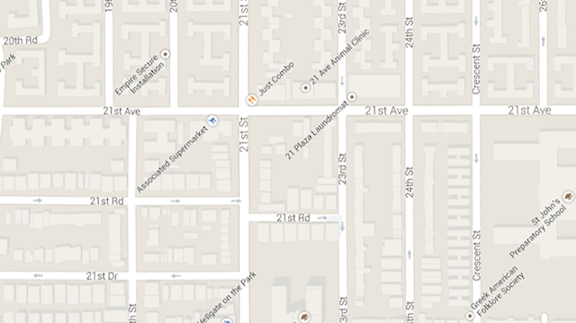
The direction: “Make a right on 21st” isn’t helpful in this part of Astoria, Queens.
As the population grew, more streets were created between existing ones, causing the phenomenon described above. Addresses in Queens also have a hyphen in them, almost as if to make it even more difficult to find your place. Don’t worry, after today’s Cities 101, you’ll be getting around the borough like a pro.
There are two things you should remember before attempting to make sense of Queens’ street grid. Avenues go east-west, with 1st Avenue northernmost, and Streets go north-south, with 1st Street westernmost. If you can keep that in mind you can use the street numbers themselves to figure out what direction you need to go.

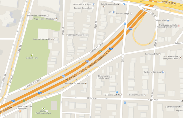
As more Streets (recall, north-south) were added when Queens grew they were given the name Place and Lane, sequentially. For example, 65th Place falls between 65th Street and 66th Street in the map above. The Places and Lanes don’t go as long as the Streets, so in this example you can not technically find yourself on 65th Avenue between 65th Street and 65th Place. However, the top image gives examples of Roads and Drives which are added sequentially for new Avenues. In that example, Associated Supermarket is located on the block of 21st Street located between 21st Road and 21st Drive.
Since that is confusing enough, there is a practice to make things easier used by the US Postal Service in Queens addresses–hyphenated house numbers. The house number gives some location information about the lower cross street. Take The Oracle Club in Long Island City, Queens located at 10-41 47th Avenue. The 10 represents the lower street, meaning that Oracle is located between 10th Street (Vernon Boulevard) and 11th Street at building number 41 on 47th Avenue.
Mind blown? Keep at it and you’ll be a Queens expert in no time. For more from our Cities 101 series, where we figure out how cities work, check out which pets aren’t allowed in NYC or what the difference is between a traffic circle and a roundabout. Special thanks to Queens Brownstoner. Get in touch with the author at @uptownvoice.
Subscribe to our newsletter