


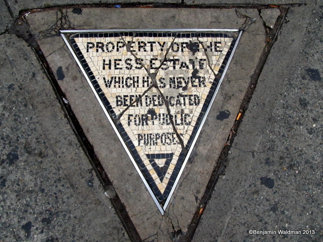

One of New York City’s most unique pieces of property was Hess Triangle, only 500 square inches and the smallest plot of land at the time. Now marked by mosaic tiles on a piece of pavement on Christopher Street and 7th Avenue, it represents one man’s final stand against eminent domain: “Property of the Hess Estate Which Has Never Been Dedicated for Public Purposes.” While Hess Triangle was combined into the Village Cigars property, there are many awkwardly shaped lots on record today with the NYC Department of City Planning and Department of Finance. One final project at Columbia University GSAPP, led by Kohn Peterson Fox architect Lucien Wilson in the Parametric Site Analysis class, looked into these “untapped” plots of land as development opportunity.
Using MapPLUTO as a source for land use data, provided by the city’s Digital Tax Map, the team which consisted of architecture students Julien Gonzalez, Mondrian Hsieh, Louis Jin and Joan Kim, filtered the tax lots by Lot Type looking for the following:
- Interior Lots: a tax lot that has no street frontage
- Island Lots: a tax lot that is entirely surrounded by water
- Alley Lots: a tax lot that is too narrow to accommodate a building. The lot is usually 12 feet or less in width.
- Submerged Land Lot: A tax lot that is totally or almost completely submerged.
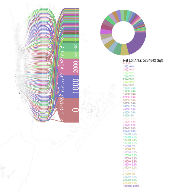
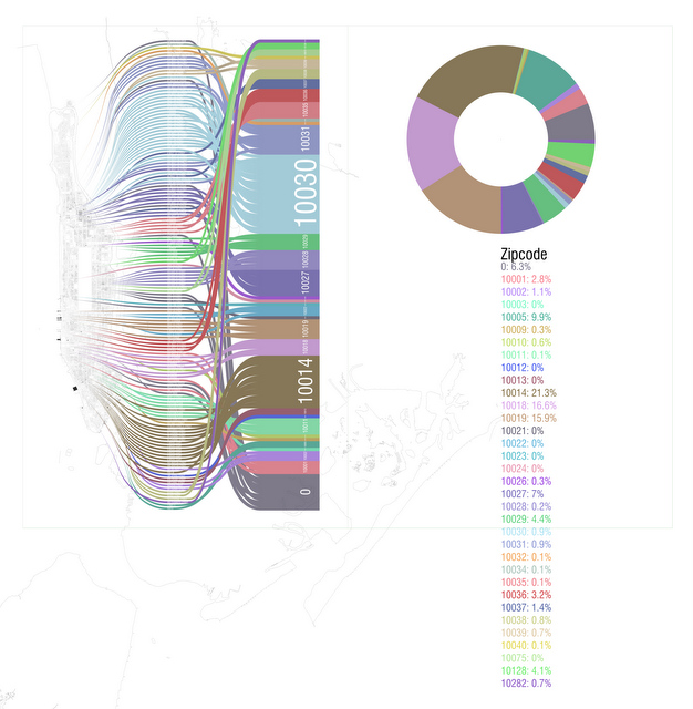
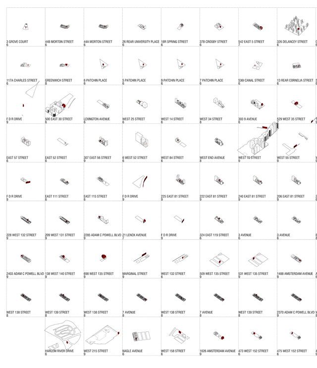
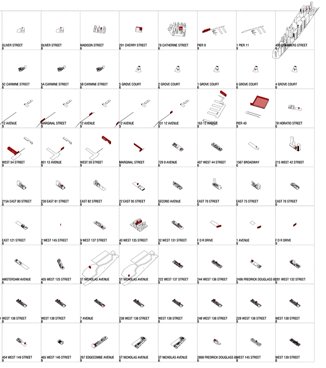
The Columbia team put themselves in the shoes of a new development firm that wanted to develop the land no one else wanted to build on in New York City. After filtering out more desirable awkward lots categorized as landmarks, Hsieh reports, “This left us with the current sampling of 143 lots, which we should note include some very valuable piers in Chelsea.” The net lot area of these types of properties total more than 5.2 million square feet. By zip code, 10014 in the West Village, 10018 in the Garment District and 10019 in Midtown, including the piers and parts of Central Park have the largest percentage of awkward lots by lot area. Zip code 10030 in Harlem had a large number of awkward plots, but it consisted of smaller lot sizes.
As Hsieh tells Untapped Cities of the process:
Watching Manhattan develop, expand, redevelop, and develop again [in Trulia Hindsight], and then just explode in the 90s and 2000s brought up some deep questions about building in Manhattan. When can you call a city built up? What motivates additional growth? What does it mean to have land in Manhattan?
This eventually led to the notion of commodified land in Manhattan, What if every square foot in Manhattan were equally coveted regardless of contiguity or ‘lot type’ for example. A really Flatiron-esque idea, and something we agreed could totally be carried out with anomalies in Manhattan’s urban morphology.
They then isolated the lots by their Block Codes, combined the MapPLUTO data with Building Attributes data (footprint, building height, etc.” which can be found through NYC Open Data and produced the maps, matrix and scenarios featured here. As seen on the below matrixes, the awkward lots are of all different shapes and sizes, ranger from a sliver on the FDR Drive to parts of a pier, or slices within some of Greenwich Village’s hidden alleys and private streets like Patchin Place and Grove Court. Lots go through backyards, between buildings, often unbeknownst to the owners. Getting rid of the awkward lots is not so easy. Each lot, no matter how small, has to be assessed for value, then sold at auction. Those considered “worthless” go through the city’s SAIL Away program in which the city tries to sell the properties to adjacent owners.
In 2013, The New York Times reported that “Vacant lots in the right part of town can sell for $14 million, for $30 million and even much more…but even here, there are properties so irregularly shaped and so unfortunately situated that they are notable not for their value but for their peculiarity—and many of them happen to be owned by the City of New York.” This article suggests that putting NYC’s vacant land to better use (including these awkward plots) could make for a more ecological city. To make things even more fun, this Columbia team decided to test out some of these vacant lots to build architecture that would be resistant to a zombie apocalypse–but that’s the subject of another article.
Check out Mapping the Great Divide in NYC Real Estate and see more from our Fun Maps Column.