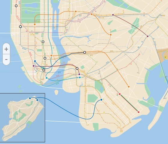
Going back into the archives, WNYC has a great interactive “Lost Subways” map that showcases the abandoned or never-completed subway stations of New York City, as well as never built lines. It’s a great tool to go along with our popular article on 7 of NYC’s abandoned subway stations. Here’s a quick rundown:
Manhattan’s Abandoned Subway Stations
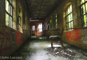
1. City Hall Station
![]()
This decommissioned subway station was the real jewel of the IRT subway line when it opened, with Guastavino tiling and a curved track. With a platform too short for the new trains, it has been closed since 1945 but is open for tours through the New York Transit Museum.
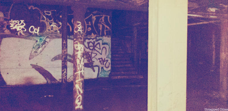
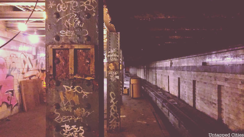
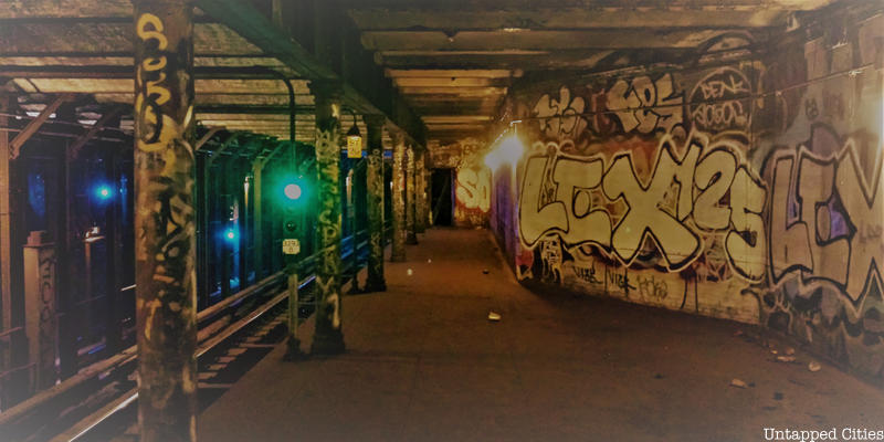
2. Worth St
 Photograph via Wikipedia by
Another abandoned stop on the former IRT line, the Worth St station was closed to passengers in 1962 due to its proximity to the Brooklyn Bridge station which had extended its platform north. Once the full-sized Brooklyn Bridge station opened, Worth St became, well, worthless. However, the station’s name bears significant meaning as it was named after General William Jenkins Worth, a hero of the Mexican War in the 1840s. On a slow moving 6 train, the word “Worth” and terra-cotta “W”’s can be spotted on some of the station’s tile-encased support columns and walls, respectively. However, it may be difficult to see much as the station is heavily defaced by graffiti.
3. 18th St
18th St, also on the IRT Line, was formerly sandwiched between 14 St-Union Square and 23 St. After World War II, the Board of Transportation embarked on a platform extension program, and this allowed 14 St and 23 St to lengthen their platforms and post new entrances at 15th street and 22nd street. As a result of the close proximity, 18 St was closed down in 1948. According to Joseph Brennan of Abandoned Stations, the underground stop was often used for publicity photos because it possessed no unusual features. The sealed off station is easily visible when riding the 6 train (and 4, 5 trains if no local trains obstruct the view) between 14 St and 23 St. See a video of the abandoned station here.
4. Port Authority Lower Level
It’s unclear why the the lower level of the A/C/E track was constructed under the Port Authority, as it never operated as part of the IND or IRT systems but it was used between 1959 and 1981 as the origin for the special Aqueduct Racetrack train (also providing access to the Rockaway Amusement Park as well as football games at the Polo Grounds in upper Manhattan).
According to NYCSubway, the platform is on the southbound side, “one track, underneath the downtown local track on the upper level, and one side platform underneath the island platform.” The entrances have all been sealed, except for one under a trap door on the “south end of the southbound platform,” at the time Peter Doughtery was writing.
5. 91st Street Station
The 91st Street Subway station on the 1 line was rendered obsolete by 1959 with the lengthening of platforms for the longer trains. NYCSubway.org reports that this station is well-preserved despite the graffiti.
Planned Subway Routes in Manhattan
1. IRT Trains Over the Manhattan Bridge
A stop and tunnel for this proposed line exists, and is an unused level underneath the Nevins Street subway station in Brooklyn.
2. 8th Avenue Line to Williamsburg
3. Manhattan Queens Connection at East 76th Street
4. The Second Avenue Subway
The Second Avenue Subway is on here, because although a portion is being built, it’s a scale down version of what was envisioned, and there isn’t money (yet) to complete anything beyond the first phase, between 63rd Street and 96th Street. I addition, as the WNYC map mentions there were various other plans to have it connect to Throgs Neck, under the Harlem River, along the Metro-North tracks, and into Brooklyn–all which have come to naught. Check out photographs from inside the construction of the Second Avenue Subway here.
Brooklyn
1. S. 4th Street, The Underbelly Project
Underneath Williamsburg at South 4th Street there’s a 6-track station of the IND line that was never opened. In 2009, over the course of a year, street artists PAC and Workhorse invited 100 street artists in and out of the station to create work there overnight. dubbed The Underbelly Project. The idea was to create an underground gallery, but as PAC describes, apart from recruiting artists they could trust from pre-existing relationships, everything “happened organically along the way.” This video tells the story and shows the art well, and the project went on to be replicated in Paris. Whether the art still exists in the NYC subway station remains a question, but most we’ve spoken to feel that the MTA sealed off the station and it has remained relatively untouched. Second Avenue Sagas has a great explanation of the unused subway station.
2. Myrtle Ave
Closed in 1956, Myrtle Ave subway station used to run on the Brooklyn-Manhattan Transit line between Manhattan Bridge and DeKalb Avenue. The DeKalb Ave section ran into a lot of problems as it was the chokepoint for the entire BMT Broadway subway operation, “with a lot of merges and some routings crossing others at grade in the switches on both sides of the station,” writes Joseph Brennan. The entire area was rebuilt in 1956, and this caused Myrtle Ave to lose its southbound platform. The northbound platform still exists, but has been closed ever since.
An artwork called Masstransiscope by Bill Brand is located in the abandoned Myrtle Ave station. Installed in 1980, the piece works like a giant zoetrope. When the train moved, riders would see an animated cartoon, not 228 hand-painted images. The piece was restored in 2008 and 2013. You can view the video here to experience art in moving transit.
You can view this by taking the Manhattan bound B or Q trains departing from DeKalb Avenue.
Planned Subway Routes in Brooklyn
1. Utica Avenue Line
Beginning at Essex Street on the F line, the Utica Avenue line would have run to the South 4th Street stop mentioned above where the Underbelly Project is, and then would have turned south down Utica Avenue. There’s a tunnel east of the Second Avenue F train that was built for this proposed line.
2. Brooklyn Queens Connection
The upper level of the Roosevelt Avenue station was built for this line that would have connected Brooklyn to Queens. Wouldn’t this have been handy…
3. Cross-Forest Hills Connector
4. 2/5 Lines Completed
The 2 and 5 lines were supposed to go all the way to Sheepshead Bay, rather than just Brooklyn College where it ends today. A tunnel was built, up to 100 feet, until the project was put on pause.
5. Staten Island to Brooklyn Link
A proposed subway to connect Staten Island and Brooklyn would have followed by path of the Verazanno Bridge underwater.
6. D Train to the East Bronx
This plan would have continued the D train after Norwood-205th Street ending at Boston Road and Baychester Avenue.
For more abandoned transit, check out:
7 of NYC’s Abandoned Subway Stations: City Hall, 18th St, Worth Street, Myrtle Ave, 91st St
9 of NYC’s Abandoned and Incomplete Subway Platforms and Levels
5 of NYC’s Never Completed or Barely Used Ghost Subway Stations
Trolley Ghosts of the Abandoned Essex/Delancey Williamsburg Bridge Rail Terminal in NYC
All maps from WNYC. Get in touch with the author @untappedmich.