How to Make a Subway Map with John Tauranac
Hear from an author and map designer who has been creating maps of the NYC subway, officially and unofficially, for over forty years!


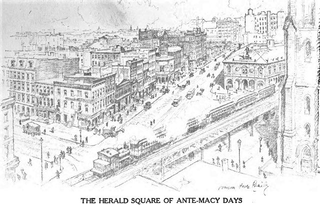
Herald Square “In 1900.” The Romance of the Store (1922)
As New York was reinventing itself from a Victorian city of rowhouses and horse-drawn carriages to a metropolis of skyscrapers, automobiles, and subways in the early years of the twentieth century, artist Vernon Howe Bailey (1874-1953) documented the city’s transition in his detailed drawings.
Bailey was one of the most popular American illustrators of the early 1900s, widely published in newspapers, magazines, and books. He even had his own series of short films, “Vernon Howe Bailey’s Sketch Book,” during the silent movie era shown in theaters across the country.
His drawings and paintings depicted small Spanish towns, naval ships, and the Vatican, but he was best known for his pencil and ink sketches of buildings and street scenes, particularly in New York where he lived for many years.
Bailey started his career at newspapers, drawing illustrations for news stories before moving on to his signature architecture drawings for major publications. A 1903 review of his work by the Philadelphia Inquirer observed that “the style he has acquired under the enforced limitations of newspaper reproduction is admirably suited to the themes he seems to select by preference.”
Today, Bailey and his sketches are mostly forgotten. However, his beautiful, expressive work now has an added value as a record of a dynamic period in New York’s history.
For example, the drawing above shows the Macy’s block in Herald Square shortly before the department store was built and also shows the Sixth Avenue Elevated with a steam-powered train passing by the now lost Stanford White headquarters for The New York Herald.
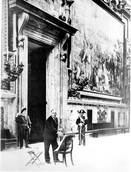
Vernon Howe Bailey in the Vatican, ca. 1930. Via Harry S. Truman Library & Museum
Here are fifteen drawings by Bailey, published from 1904 to 1916. They appear roughly in geographic order, moving up Manhattan from south to north.
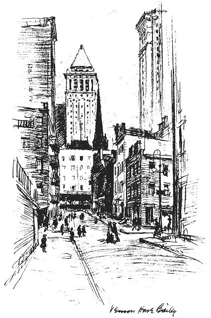
“Contrasts – the Bankers Trust and the Down Town Tenement, with Trinity’s spire in the middle distance.” Electrical New York (1916)
This drawing, published in 1916, shows a view looking east from Carlisle Street in lower Manhattan. The tenements in the foreground are no longer there; that area is now a cleared development site with plans for a 51-story building. The building in the distance with the pyramid roof is the Bankers Trust building, at 14 Wall Street, completed in 1912. Intervening buildings are now seen from this spot on Carlisle Street instead of Bankers Trust.
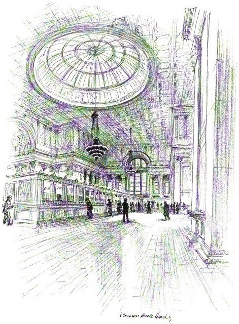
“National City Bank.” Electrical New York (1916)
This drawing shows the interior of 55 Wall Street, built in 1842 for the Merchants’ Exchange. It has been home to the New York Stock Exchange, used as the US Customs House, headquarters of National City Bank (now Citibank), and the Regent Wall Street hotel. Bailey’s drawing shows the banking hall, the product of a remodeling and expansion in 1908-1910, designed by architects McKim, Mead, and White.
The building is now Cipriani Club Residences with high-end luxury condos and the banking hall is used as an event space.
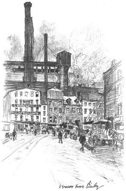
“Looking Down Greenwich Street Toward Globe Square.” Electrical New York (1916)
In the tradition of Times and Herald Squares, Dey Street west of Greenwich Street was co-named Globe Square by the City in 1911 in honor of the New York Globe and Commercial Advertiser newspaper, which had its headquarters there. After the Globe closed and the New York Evening Telegram moved into the old Globe building, the City renamed the area Telegram Square in 1924.
The building in the distance, with the smokestacks, was a coal-fired power plant of the New York Steam Company.
This entire area was cleared for the construction of the original World Trade Center in the 1960s and today the 9/11 Memorial Museum stands in the approximate location of Globe Square.
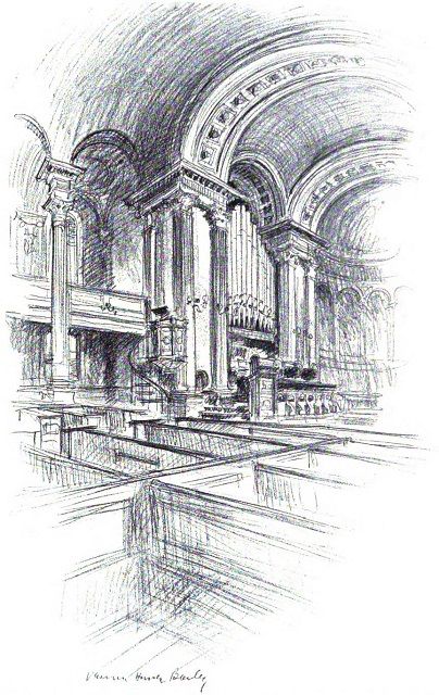
“Old St. John’s in Varick Street.” Electrical New York (1916)
St. John’s Chapel was an Episcopalian church on Varick Street dating from about 1807. By the early 1900s, the once posh residential area was industrial and the City was planning to widen Varick Street. Despite a campaign to save the historic and much loved building, it was torn down two years after the publication of this drawing.
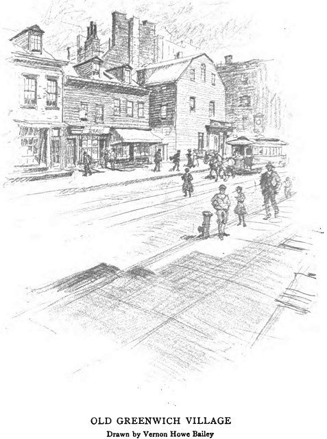
“Old Greenwich Village.” Thirty Years of New York, 1882-1912: New York Edison Company (1913)
Though published in 1913, this drawing depicts an earlier scene in Greenwich Village, likely from the late 1800s. The street is not identified, but the horse-drawn trolley shown in an indicator of an age before the transformation brought on by electricity and horseless carriages.
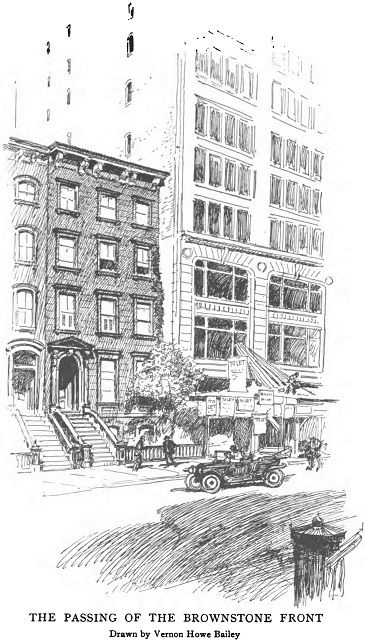
“The Passing of the Brownstone Front.” Thirty Years of New York, 1892-1912: New York Edison Company (1913)
In his drawings, Bailey often celebrates the new while also documenting the old slipping away. This drawing is a general commentary on the architectural transition that the city was experiencing in the new century. Brownstones were no longer being built and many were being replaced by new, larger and taller buildings faced with other materials including limestone and brick.
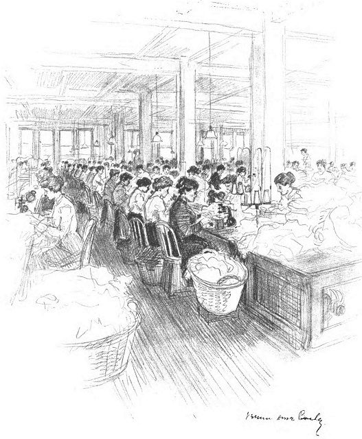
“Fifth Avenue, the Fashion and Wealth Centre of New York is the Factory District of This Great City.” Electrical New York (1916)
This drawing by Bailey appeared only five years after the devastating Triangle Shirtwaist Fire that killed 146 workers, mostly young immigrant women. With this tragedy, public concern over factory working conditions were brought into focus.
Whether this drawing represents an actual scene or an idealized setting is unknown, but at the very least, it shows how workers were packed onto factory floors even post-Triangle Shirtwaist.
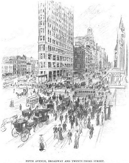
“American Cities in Pencil, III, New York: Fifth Avenue, Broadway and Twenty-third Street,” Everybody’s Magazine, May, 1904
The Flatirion Building, completed in 1903, the year before this drawing was published, remains a familiar site to New Yorkers. However, Bailey shows the hustle and bustle of “Flatiron Corner” with a very different context: horse-drawn carriages, trolleys, and fancily-dressed pedestrians on their way to and from the Ladies’ Mile shopping district.
Bailey made this drawing from the Fifth Avenue Hotel; note the balcony at the extreme right. The hotel, built 1859, was replaced a few years later by the International Toy Center, a building now better known as the home of Eataly.
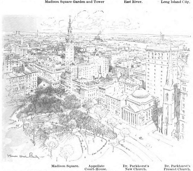
“New York from the Flatiron: Looking to the Northeast.” Munsey’s Magazine, July, 1905
According to a 1911 New York Times article, Bailey’s office was “perched on the very top of the Flatiron Building.” In 1905 he captured the area along the east side of Madison Square from the Flatiron. At the right is “Dr. Parkhurst’s present church,” as the Gothic-style Madison Square Presbyterian Church was known, soon to be demolished and replaced by the Metropolitan Life Clock Tower building.
“Dr. Parkhurst’s New Church,” completed in 1906, would only stand for 13 years before it too was replaced by a Met Life tower. Designed by Stanford White, the new Beaux-Arts style church was one of New York’s shortest lived architectural gems.
Down the street was the second incarnation of Madison Square Garden with its iconic tower. White, who also designed it, was murdered there in 1906 by his former mistress’s husband. The New York Life building now stands at that location.
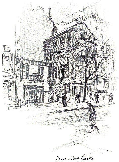
“A Relic of Old New York – the Junk Shop on East 29th Street.” Electrical New York (1916)
The wood frame building at 203 East 29th Street was already considered old a century ago when Bailey sketched it, perhaps with the expectation that like so many other older building it soon would be replaced. Improbably, it has survived to the present day.
Although this relic has a long history, its exact age is unknown. It is listed on the National Register of Historic Places, however it is not a designated NYC Landmark meaning it could be torn down or its facade altered as long as no public funds are used.
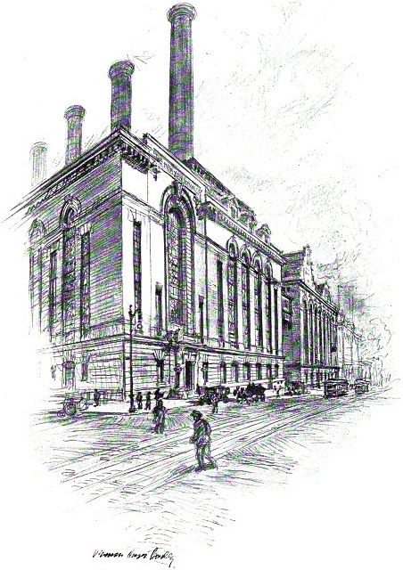
“Waterside.” Electrical New York (1916)
One of many Bailey drawings commissioned by the New York Edison Company, here he showed the company’s massive Waterside power plant on First Avenue between East 38th and East 40th streets. Originally a coal-powered steam facility, its name was a reference to its location along the East River which allowed for delivery of coal by ship.
Waterside, which consisted of two buildings, was built in the early 1900s and demolished starting about 2005. A major real estate development has been in the works for the site for the last decade.
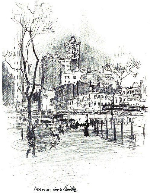
“In Bryant Park.” Electrical New York (1916)
Bailey’s 1916 Bryant Park sketch contains both the familiar and unfamiliar. The park does not look so different today and in the distance is the Hotel Knickerbocker, located at Broadway and West 42nd Street, which earlier this year began operating as a hotel again after it was converted to office use in 1920s.
To the right of the Hotel Knickerbocker is the New York Times Tower, which still stands and hosts the New Years’ Eve ball drop. However, the Times Tower has been massively altered from its original condition. In any event, neither the Knickerbocker nor the Times Tower can be viewed from Bryant Park, due to larger and taller buildings that replaced the low-rise buildings on Sixth Avenue facing the park.
The Sixth Avenue Elevated has been gone since the late 1930s. The Sixth Avenue subway provides the same function without the El’s visual and audible intrusions on the park.
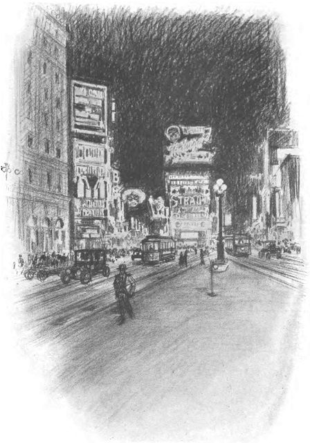
“The Lights of Broadway.” Thirty Years of New York, 1882-1912: New York Edison Company (1913)
This is another Bailey drawing that shows not only changes but also continuity. Over a century later, Times Square has changed but is still recognizable. Broadway’s nickname The Great White Way comes from the electric lights and spectaculars that came to dominate the theater district.
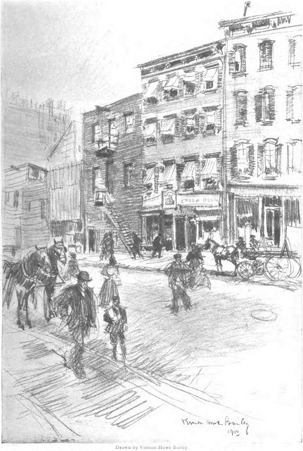
“Rough Places in Gotham: In “Hell’s Kitchen” on the West Side,” The Century Magazine, September, 1910
Long before Jessica Jones started cleaning up Hell’s Kitchen, this sketch was part of a magazine piece Bailey did in 1910 showing “Rough Places in Gotham.” It follows in the footsteps of Jacob Riis, whose 1890 book How the Other Half Lives raised public interest in the conditions of the urban poor. The magazine text referred to Hell’s Kitchen as “a district which has been prominent in newspaper annals,” alluding to its then sordid reputation.
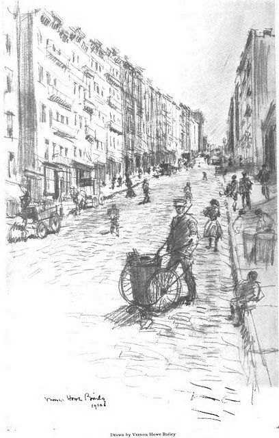
“Rough Places in Gotham: “San Juan Hill,” on the Middle West Side,” The Century Magazine, September, 1910
Also from “Rough Places in Gotham,” Bailey’s sketch of San Juan Hill shows a neighborhood that was described in the magazine as a “negro tenement district.” San Juan Hill is one of the lost neighborhoods of New York, eliminated in the 1950s by Robert Moses’ urban renewal projects that created Lincoln Center and the Manhattan campus of Fordham University.
Next, check out Gilded Age architecture depicted in lively illustrations by Eric Rosner and 750 years in Paris visualized by lively illustrations by Vincent Mahé. Contact the author @Jeff_Reuben
Subscribe to our newsletter