NYC’s Forgotten ‘War on Christmas Trees’
Discover how an obscure holiday crackdown affects festive street vendors today!


In late March 1906, less than a month before San Francisco would be rocked by a massive earthquake, artist Vernon Howe Bailey visited the city to make pencil sketches of notable buildings and urban landscapes. These drawings, now mostly forgotten, captured scenes that soon would be jarringly altered.
Bailey’s arrival on March 28 was of sufficient local interest that the next morning the San Francisco Call ran an article reporting that “the famous artist of the east arrived.” He was dispatched by Everybody’s magazine, as part of a series, “American Cities in Pencil,” that he was doing for the monthly publication. He completed his work and moved on to other locations by early April.
The earthquake struck at 5:13 AM on Wednesday, April 18, 1906 and shook the city for nearly a minute. Besides structural damage to many buildings, it also ruptured many gas lines and water mains. Soon, fires were raging throughout the city and water was in short supply. The fires lasted for over three days and by then 3,000 people had died and it is estimated that more than half of the city’s population was made homeless.
We present here the eight drawings by Bailey, drawn in his beautifully expressive style, that were published in the June 1906 issue of Everybody’s. We also look at what happened to these sites during the earthquake and afterward.
All Vernon Howe Bailey drawings, Everybody’s, June 1906, via Google Books
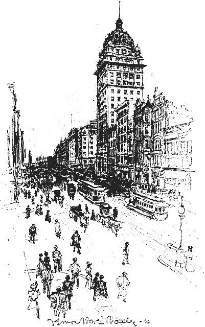
One of Bailey’s strengths as an artist was capturing both the beauty of architecture and the vitality of urban street life. Market Street was, and still remains, a key downtown thoroughfare, bustling with activity. The bustle of the street was also famously captured in a video from 1906, showing the risk to life and limb while traversing it. Market Street was home to the Spreckels Building, San Francisco’s tallest structure when built in 1898. Also known as the Call Building, for the newspaper located there, it was a steel frame building with a sandstone exterior topped by a dome with many ornate details.
The Call Building remained standing after the earthquake, but like so many buildings it caught on fire. Although the fire damage was extensive, the buidling was repaired and reopened.
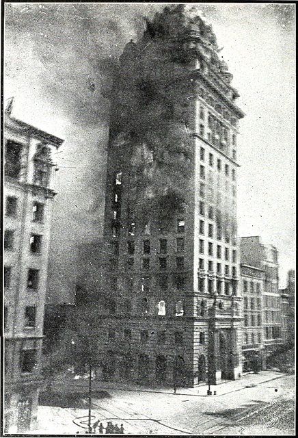
“San Francisco Call Building (1906)” via Wikimedia Commons
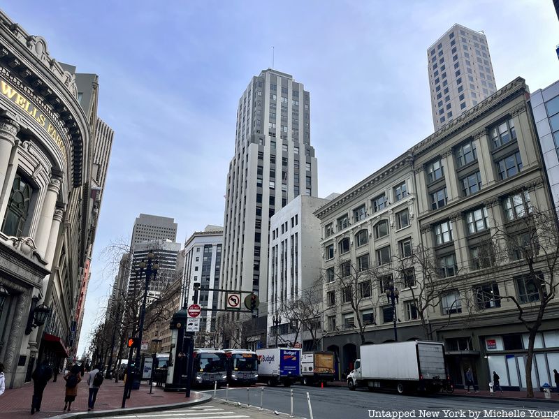
Ironically, the building that survived the calamity of 1906 underwent a total makeover in the 1930s that completely changed its appearance. The dome was removed and the sandstone was replaced by a light pink granite Art Deco facade. It is now known as Central Tower.

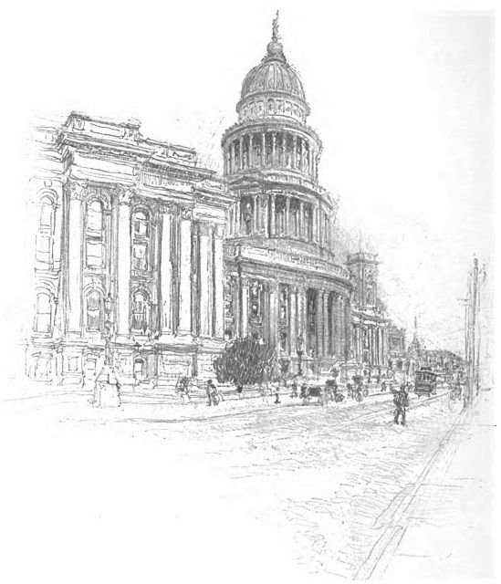
City Hall in San Francisco, which took 27 years to build, lasted only 6 more. A distinctive edifice with domes and a columned facade, construction started in 1872 and was completed in 1899. It suffered major structural damage from the earthquake, an indication according to some that many corners were cut during its lengthy construction.
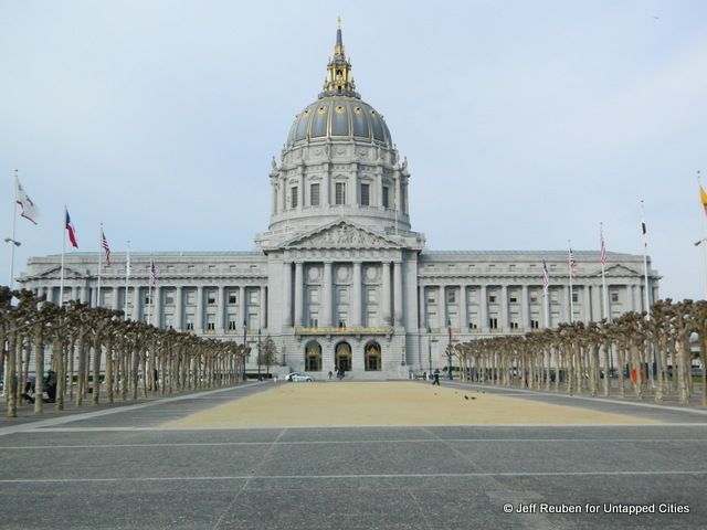
“New” San Francisco City Hall
A new Beaux-Arts style City Hall, with a dome taller than the US Capitol, was completed in 1915 a few blocks away as part of the Civic Center project. The 1915 City Hall was damaged by the major earthquake that hit San Francisco in October 1989, but unlike in 1906 it could be repaired. The site of the old City Hall is now occupied by the San Francisco Main Library.
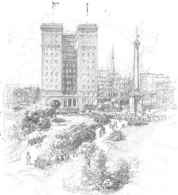
Union Square, the great public space of downtown San Francisco, was coming into its own by 1906. A monument to Spanish-American War hero Admiral George Dewey was erected there in 1903 and a state-of-the-art hotel facing the park, called the St. Francis (using the English equivalent of the city’s name), was completed in 1904.
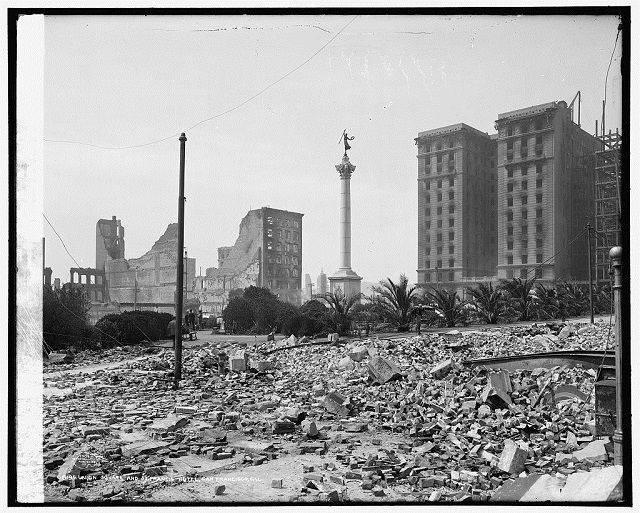
“Union Square and St. Francis Hotel, San Francisco, Cal.” Photo by Detroit Publishing Co., via Library of Congress
Most of the buildings around Union Square were destroyed by the fires that followed the earthquake. Initial press reports stated that the St. Francis was in ruins; in fact, although it experienced fire damage, the building survived and it reopened in 1907 after repairs were completed. The hotel has been expanded and renovated several times since then, and now operates as the The Westin St. Francis.
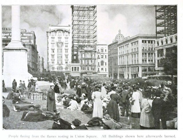
“People feeling from the flames resting in Union Square. All buildings shown here afterwards burned”, via Vintage Printable in public domain
The Dewey Monument, though damaged, also survived and still stands in the square.

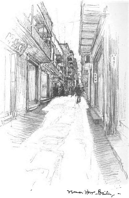
Contemporary accounts of San Francisco’s Chinatown viewed it through the prism of prevailing racial stereotypes; at best Chinatown was an “interesting spectacle” and at worst it was an overcrowded den of iniquity. The text by writer Will Irwin that accompanied Bailey’s drawing reflects both of these sentiments. “Every tourist felt bound to see the Quarter. Guiding tourists was an industry; but the guide showed only a circus performance.” On the other hand, Chinatown’s “highbinder wars kept the police busy.”
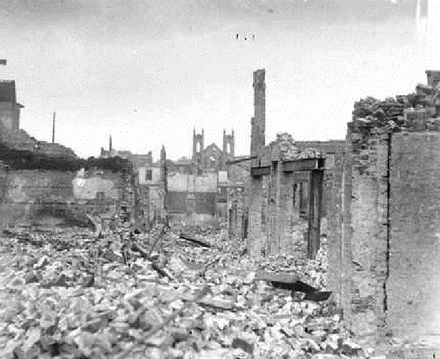
“San Francisco Chinatown 1906.” Photo by Chicago Daily News, via Wikimedia Commons
With its older, alley-lining buildings, most of Chinatown was destroyed by the combination of the earthquake and fires.
There was talk after the earthquake of relocating Chinatown elsewhere, given its proximity to business areas. Thanks in part to lobbying efforts by neighborhood Benevolent Associations, Chinatown was rebuilt in place, where it continues today as an ethnic neighborhood and commercial district.
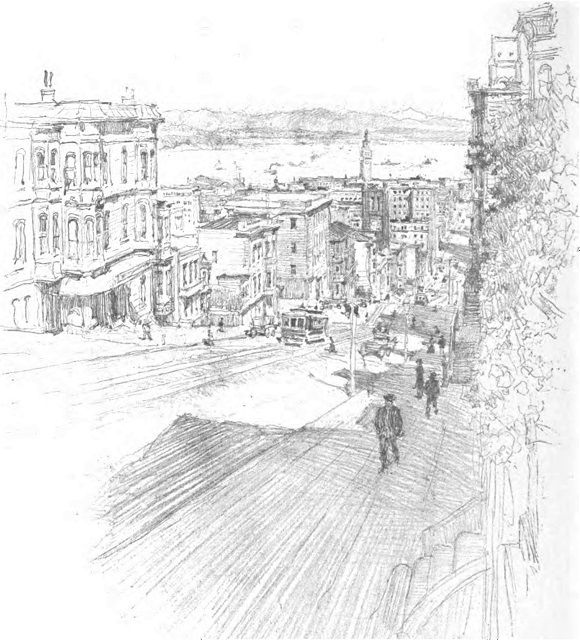
In this sketch, Bailey shows the view down California Street looking east from Nob Hill. On the left, about midway down the street is the belfry of Old St. Mary’s Roman Catholic Church, which was originally built as a cathedral in the 1800s but by 1906 was a parish church. Behind Old St. Mary’s in the distance is the iconic clocktower of the Ferry Building.
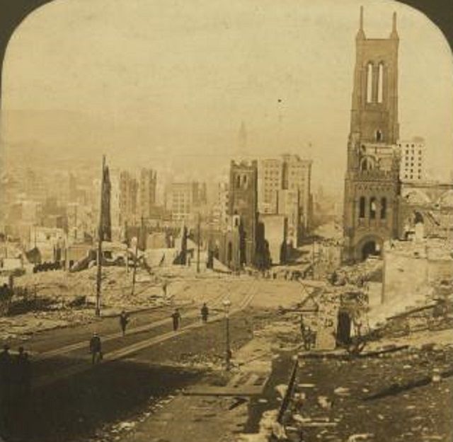
“Looking down California St.; Ferry Building in distance, San Francisco Disaster, U.S.A” Photo by H.C. White Co., via NY Public Library Digital Collections
Many of the buildings along California Street were destroyed. However, as shown in the photo above, Old St. Mary’s was still standing, though fire ravaged the structure. Apart from its brick walls, the rest, including the marble altar, was reduced to ashes. The church was rebuilt in 1909 using the surviving walls and it continues to operate as a church today.
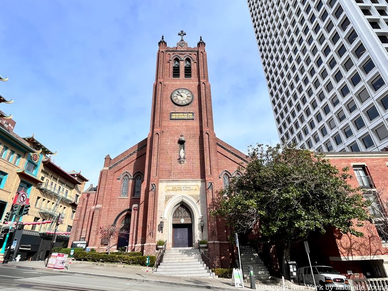
As destructive as the earthquake and fires were, examples like St. Mary’s, the Call Building, and the St. Francis Hotel are testaments to the city’s amazing recovery.
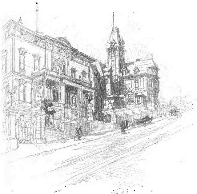
Located northwest of downtown, Nob Hill long has been one of San Francisco’s poshest neighborhoods and was home to some of the city’s most notable Gilded Age mansions. In this sketch Bailey shows the Leland Stanford and the Mark Hopkins mansions.
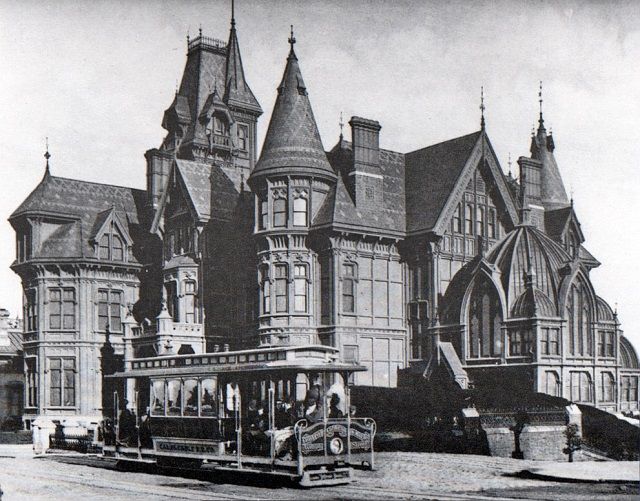
“Mark Hopkins Mansion, California Street, 1890s” via Wikimedia Commons
While Bailey presents a view looking uphill on California Street, allowing him to depict both mansions, this may be one case where a pre-earthquake photo is necessary to show fully the grandeur lost. The photo above presents a view from the top of Nob Hill, looking at Hopkins Mansion from the other direction on California Street.
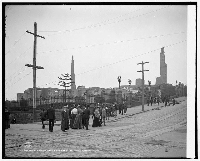
“Ruins of Stanford Mansion and Hopkins Art Institute, San Francisco, Cal.” Photo by Detroit Publishing Co. via Library of Congress
By 1906, both homes had changed to collegiate uses; the Stanford Mansion recently had been given to Stanford University and the Hopkins Mansion had become the Hopkins Institute of Art, a unit of the University of California. Both were destroyed by fires after the earthquake, as were many other Nob Hill mansions and homes.
These two mansions were replaced by larger buildings; Stanford Court, originally an apartment house and now a hotel, and the InterContinental Mark Hopkins Hotel.
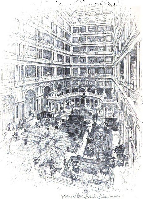
The Palace Hotel, completed in 1875 and located downtown on Market Street, was one of San Francisco’s grandest hotels both in size and in luxury appointment. Bailey sketched its great public space, the Palm Court, which was an interior courtyard with natural light provided through a 7-story high skylight. Originally a courtyard for carriages, about 1900 it was converted to a lounge.
When the earthquake struck, the Palace Hotel remained standing, but subsequently was destroyed by fire. The photo above, showing the Palace Hotel on fire, was taken by Arthur C. Pillsbury, who had founded his picture company in Oakland only a month earlier.
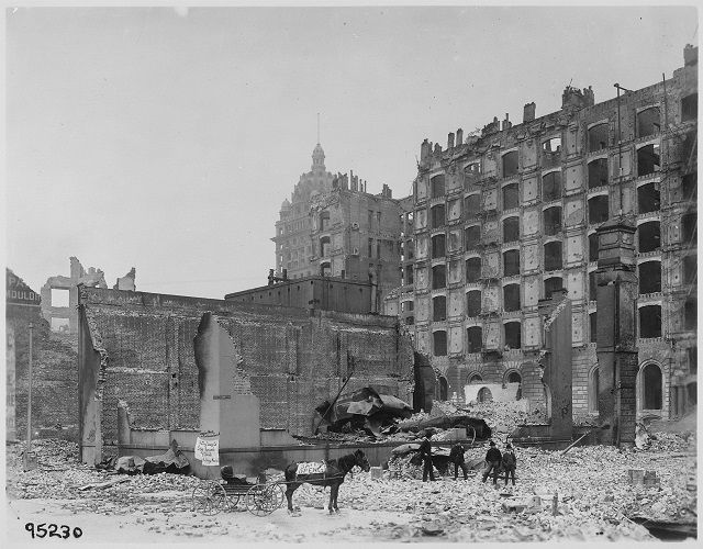
Building at right is Palace Hotel. Photo by Department of War. via Wikimedia Commons
The Palace Hotel was replaced by a new Palace Hotel completed in 1909. The new hotel still exists, though it underwent a major seismic retrofit after the 1989 Earthquake. On the site of the old Palm Court, there is a prestigious restaurant with glass dome ceiling called the Garden Court.
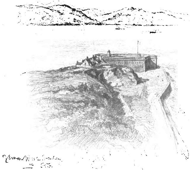
Fort Point is a nineteenth century defensive fortification located on the shoreline of the Golden Gate, which is the strait that connects San Francisco Bay and the Pacific Ocean. The structure was only lightly damaged by the earthquake, but the fort and the land around it were used as a refuge center in the aftermath.

“Giving Clothing, Fort Point” Photo by Pillsbury Picture Co., via Library of Congress
Fort Point still exists today and is now open to the public as part of Golden Gate National Recreation Area. However, its visual context was greatly altered in the 1930s with the construction of the Golden Gate Bridge immediately adjacent to it. A little like New York’s Jeffrey’s Hook Lighthouse next to the George Washington Bridge, the bridge dwarfs the once imposing looking fort.

Next, read about the architecture of San Francisco’s Civic Center, SF’s Chinatown in the 21st century, and Vernon Howe Bailey’s drawings of New York City. Contact the author at @Jeff_Reuben
Subscribe to our newsletter