About a week ago, New York City celebrated the anniversary of a day long thought to be just an urban legend: an alligator in the sewer system. On February 10th, 1935, the New York Times reported that a live alligator had been pulled out of a manhole on East 123rd street by the Harlem River turning myth into reality (although sightings are still officially legend).
To celebrate the odd holiday and New York City’s sewer systems, Hunter College in Manhattan recently hosted a lecture sponsored by NYC H2O centered around Tibbetts Brook in the Bronx. One of these presentations was given by urban explorer Steve Duncan, known for his adventures and photographs of sewers around the world. Duncan, in an interview with the New York Times, reveals that the Tibbetts Brook sewer is “one of the most beautiful sewers [he’s] seen anywhere.” And of anyone, Duncan would be the expert on sewers – traversing the world to photograph them.
The lecture discussed the future of the city’s underground streams and the effort to “daylight” some of them. To “daylight” a stream basically means to bring it back to the surface and separate it from any kind of sewage system – successfully done near New York City with the Saw Mill River in Yonkers. The stream in question for the talk was Tibbetts Brook, which flows from White Plains south to Van Cortlandt Park and disappears in one of the park’s lakes.
One day, Duncan decided to see what exactly had become of Tibbetts Brook. After jumping in, he found that the fresh water stream had been merged with a sewage line. This stream, along with many others, was a major source of transportation and water for New York City in the 17th, 18th, and 19th centuries. In a post on Narrative.ly, Duncan describes that “over time many of these small streams became inadequate for the growing populations that had sprouted up on their banks, and instead of supplying freshwater they became polluted nuisances.” Other non-water transportation methods came to the forefront, and Tibbetts Brook was buried.
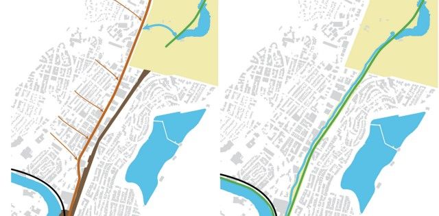
So what’s next for Tibbetts? Where exactly would it be “daylighted”? Situated between Van Cortlandt Park and the Harlem River is the former route of the Putnam Rail Line (which has its own controversial renovation plans in the works). Tibbetts would be opened up on the south side of Van Cortlandt Lake which would allow the lake to drain directly into the Harlem River instead of being funneled through a sewer first.
According to Friends of Van Cortlandt Park, the 1.45 million gallons of water per day flow from the lake into the sewer. Normally, the water runs through Wards Island Sewage Treatment Plant and then into the East River. The trouble comes during storms. Excess stormwater causes the sewer system to overflow into the Harlem River – a situation that occurs all over New York City, not just here.
These overflows cause one of the highest discharge volumes of sewage water into the Harlem River. By allowing clean water to flow naturally from the lake through Tibbetts Brook, it would minimize the amount of polluted water being dumped into the Harlem River.

Before (left) and after (right) of project. Images via Siteation
Steve Duncan has explored many of New York City’s sewers and streams, like the Minetta Brook. He knows how the underground is connected and the history of the relationship between the city and water. Below are a few of his photographs of other sewers from by Steve Duncan, via the site Metalocus. Although the idea of photographing sewers seems like it would be unsettling to look at, Duncan is able to bring out the odd beauty of a city’s typically forgotten underbelly. For more information and more images, take a look at Steve Duncan’s photography at Undercity.org.
Head above ground next with New Photo Exhibit Focusing on NYC’s Harlem River Bridges.

