✨You Can Touch the Times Square New Year's Eve Ball!
Find out how you can take home a piece of the old New Year's Eve ball!


We’ve been following the Lowline project for several years and the organization is one of our partners in our tour, the Past, Present and Future of the NYC Subway, which provides docent-led access to the Lowline Lab. In July, the Lowline received city approval a little less than four years after the project began. The Lo-Down recently released the 156-page proposal that the Lowline submitted this past February in response to NYCEDC’s Request for Expressions of Interest (RFEI) for the former Essex-Delancey trolley terminal site that the world’s first underground park will be located in.
The Lo-Down notes that although the proposal was only supposed to be accessible via applications under the Freedom of Information Act, the Lowline wanted it publicly accessible and allowed for its release with approval from the NYCEDC. You can view the whole proposal embedded below, but first, a few highlights.

Inside the Lowline Lab
To orient yourself to these maps, the Lowline site exists under Delancey Street roughly between Norfolk Street and Clinton Street. In satellite maps, it’s denoted on the ground partially by a sliver of a parking lot site but there will eventually be a new pedestrian plaza created by NYC DOT in this area, along with buildings that are part of the new Essex Crossing development.
The process to acquire this site and have it zoned for the Lowline purposes has multiple stages, including to a surrender of the property from the MTA to New York City, demapping of this part of the Delancey Street so that it can be leased, a rezoning of the site, a number of other steps. This would require approval through ULURP, the Uniform Land Use Review Procedure, which in turn requires an environmental review (CEQR). This means that the entrances to the Lowline are not fully decided yet and will be based on what type of approvals the organization gets in this process.
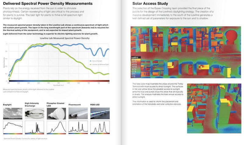
The below Solar Access Study shows the areas around the trolley terminal site with most access to direct sunlight. The scale goes from most access to least, from yellow down to blue.
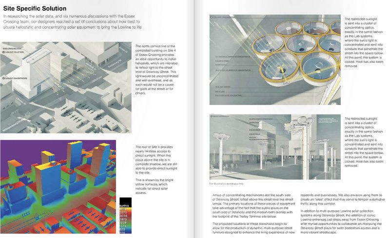
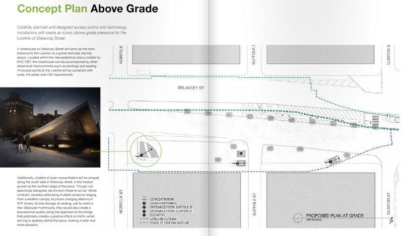
Using the current plans for Essex Crossing buildings in construction and on the way, the team determined that some of those buildings would be ideal places to install “heliostats,” which would reflect light from the top of the building down to the street in such a way that would not create glare. The redirected sunlight would be sent to a cluster of optics along the southside of Delancey Street which would send the light down below street level, exactly as the Lowline Lab is currently testing now in the warehouse. These clusters may also serve as street furniture and could take multiple forms, with a weather canopy, seating, phone charging stations, Wi-Fi kiosks listed as possible examples.

The optic clusters seen from below being tested inside the Lowline Lab currently
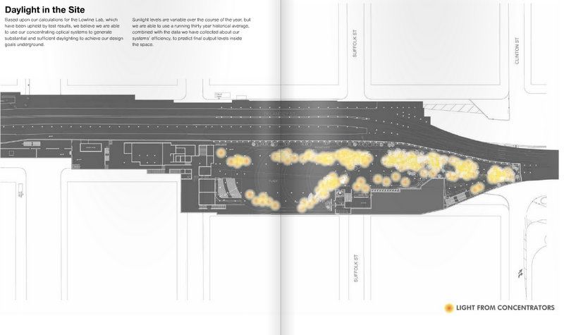
Here is a schematic showing light from the concentrated optics in the underground space:
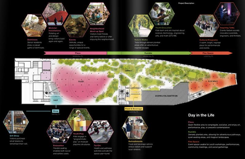
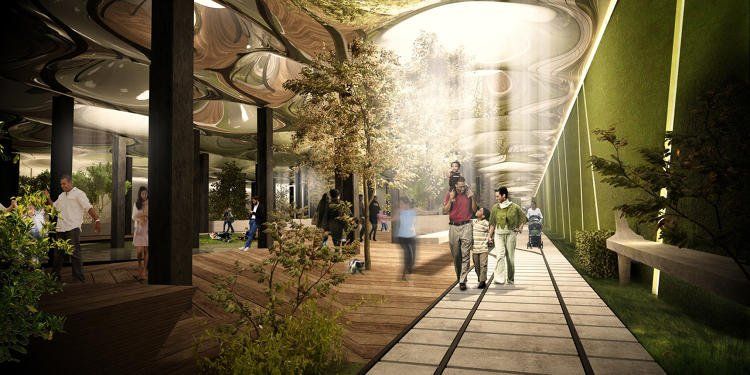
The below grade plan is designed by Raad Studio in a concept “that celebrates the intersection between old and new, and serves to make each, more powerful.” The western portion of the site will be a public plaza, which will showcase the steel, vaults, rivets and cobblestone of the original trolley terminal. It will be a space for congregation as well as events, with a gift shop. The eastern portion, which is smaller, will be an “undulated planted terrain,” the designers say is inspired by Frederick Law Olmstead‘s design for the Ramble in Central Park.
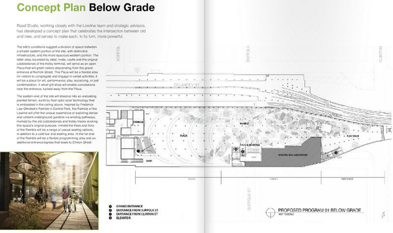
Above ground, there are plans for a “headhouse” that will be the main entrance of the Lowline at the southeast corner of Norfolk and Delancey Street within the new pedestrian plaza that’s coming.
The colored rendering gives a better idea of the division of space and the meandering paths within the ramble. It also shows a flex space on the most eastern side.

There’s a wealth of more information in the proposal, from the community building the founders hope the park will encourage, economic impact for the neighborhood, schedule (a 2021 completion), fundraising plan (which is a mix of private sector fundraising, public sector fundraising on the city, state and federal levels, and tax credits), and capital budget. The construction budget has a range between $66.4 and $107.9 million), and the operating budget is estimated at $2.688 million per year. This is all based on the assumption they will be able to lease the site for $1 a year, a customary sum for large city-backed projects. (Check out 10 other properties in NYC sold or leased for #1 in the past). They estimate that the Lowline will attract up to 3.1 million visitors per year in the high scenario, 1.56 million in a medium scenario.
Here’s the full report:
Visit the Lowline Lab with a docent as part of our comprehensive tour of NYC subway‘s Past, Present and Future:
Underground Tour of the NYC Subway
Next, see photos from inside the Lowline Lab.
Subscribe to our newsletter