


Located in South Brooklyn along Jamaica Bay, Marine Park is a neighborhood full of history and secrets dating back to the Native American era through the Dutch, Colonial, Civil War, and the present. The quiet residential area has a suburban feel in some areas, punctuated by commercial stretches, with access to a wild, natural waterfront. Check out the top 10 secrets of Marine Park:
10. Golden Gate Fancy Fruits, A Shop Frozen in Time

Inside Golden Gate Fancy Fruits and Vegetables
“You’ve just stepped into 1939,” says John Cortese, the 92-year-old proprietor of Golden Gate Fancy Fruits and Vegetables, on Flatbush Avenue in Marine Park. Indeed, the old-school grocery is far more authentic than any Hollywood set designer can create It’s a true neighborhood establishment, in operation at this same spot since 1939, when John’s grandfather opened it. John is a veteran of the Normandy invasion in World War II and has stories, and stories to tell. See more photographs of Golden Gates Fancy Fruits and learn more about the indomitable John here.
[Update: John has passed away, as of April 2020. Read our tribute here.]
9. The Underground Railroad Connection in the Historic Lott House
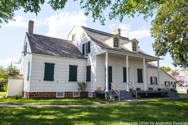
The Hendrick I. Lott House, a house built originally in 1720 and expanded (and possibly moved some feet over) in 1800, is the historical gem of Marine Park. 200 acres of the land in this neighborhood, originally the town of Flatlands, used to belong to the Lott family and the house was the longest continuously owned home by a single family in New York City. The last resident, Ella Suydam died in 1989. The house became abandoned and within a decade, it was deteriorating from the elements. It was also a popular spot for local teenagers, who dared each other to go into the “haunted” house.
It’s one of those old houses, full of secret rooms and curious spaces. The existence of one space, the “closet within a closet” was a staunchly kept secret within the family into the late 20th century. The Lott’s freed their slaves about two decades before the state of New York abolished slavery and it is believed that the house was later used as a stop on the Underground Railroad, helping escaped slaves reach freedom in the northern United States and Canada.
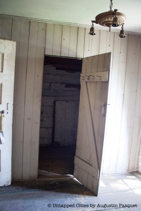
Through a door behind one of the parlor rooms, turn up a winding staircase to the second-floor rooms. Inside the first room on the right, there’s a closet under the gabled roof. Within it, there’s a second doorway that leads to a small crawlspace. Originally, the closet would have been filled with possessions, concealing this second doorway and the secret space. Dates on old New York newspapers that cover the inner wall of the closet are still visible. Several say 1862, printed just a few weeks before the Battle of Gettysburg.
The city purchased the home from the Lott family in 2001, saving the house from possible demolition and the land from being subdivided. It’s a New York City landmark and is currently undergoing rehabilitation to both the house and the surrounding property.
8. There’s a Man-Made Island in Marine Park
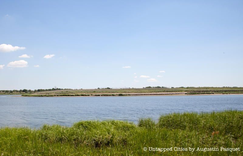
In an inlet between Gerritsen Beach and the Marine Park Golf Club is an abandoned island about 0.7 miles long that is completely man-made. Like much of the south Brooklyn waterfront, the story of Mau Mau Island is rather trashy – that is, tied to garbage and landfill.
In 1917, Francis B. Pratt, son of the industrialist Charles Pratt (who founded Pratt Institute), and Alfred Tredway White, the Wall Street philanthropist behind Brooklyn Botanic Garden, donated 150 acres of land in south Brooklyn to be saved as natural marshland. White died tragically in 1921, but he would have been horrified if he knew what Robert Moses did on this land in the 1930s. With ocean dumping banned in New York City by the Supreme Court, Moses decided to take the city’s trash to fill in marshlands. Using this method, he created Marine Park.
Robert Moses also layered sand on top of the garbage, a method that “unintentionally restored the coastal grassland habitat,” writer Robert Sullivan says. The sand came from the excavation of the Belt Parkway, another Moses initiative. To prevent the sand from blowing onto the Marine Park Golf Club, which opened in 1964, a layer of asphalt was added.
An environmental restoration was supposed to have started in the late 1990s. Despite a decade delay, work commenced in the last decade, and in recent years, some of the grasslands and marshes have been restored to the island.
Most New Yorkers have never heard of Mau Mau Island, but it had a brief claim to fame in 2011 as the site of a mock naval battle by the art collective Swimming Cities, founded by the artist Swoon. Sea vessels made out of reclaimed materials fought in the epic Battle for Mau Mau Island. But for the most part, Mau Mau Island is quietly turning into the marshland and bird sanctuary envisioned by Alfred White and Francis Pratt.
The best way to see Mau Mau Island is by kayak or canoe on trips run by the New York City Parks Department. You can also see it on a nature trail that starts at the Marine Park Salt Marsh Nature Center.
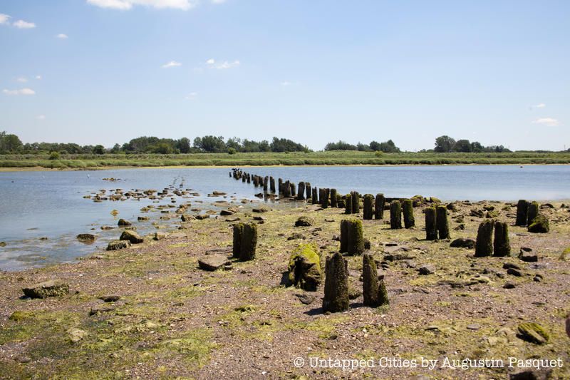
7. Remnants of the Gerritsen Grist Mill
Gerritsen Creek gets its name from the Gerritsen family, early Dutch settlers who inhabited this area of Brooklyn for three centuries. This creek was also the original port of entry for the Dutch and an important trading dock for south Brooklyn. In the mid-1600s, Hugh Gerritsen built a grist mill upon this creek, the first tide-powered mill in North America, according to the New York City Department of Parks and Recreation. The mill ground flour, corn, and grains for the troops in General George Washington’s army in the American Revolutionary War when they were stationed in Brooklyn.
It was later captured and used by Hessian soldiers, contracted military from present-day Germany that fought for the British. The Gerritsen grist mill operated until 1889 and the Gerritsen family property was sold to Gilded Age tycoon William C. Whitney in 1899, who built a country estate where he could train his race horses. He donated the property to the city before his death in 1904, and in 1928, the Whitney estate announced that they would restore the mill.
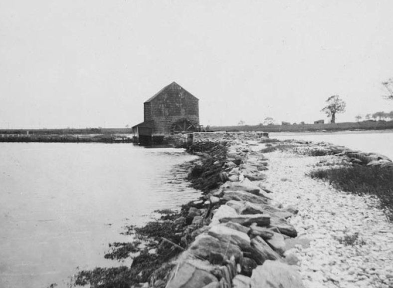
Gerritsen mill in 1922, looking west from tidal dam. Eugene L. Armbruster Photograph Collection, PR81, Department of Prints, Photographs, and Architectural Collections, New-York Historical Society.
Historian Tom Whitford has called the mill, “an absolute marvel” and quite advanced technologically, able to operate continuously even with the ocean tides. Whiteford says the mill was also used as a place for social gatherings – ice skating in winter on the mill pond, picnics in summer – and a place for oystering.
By 1930, the Brooklyn Daily Eagle was noting that “hoodlums and vandals [had] done considerable damage to the Whitney mill and dam property.” In 1931, the community was expressing concern for to its “neglected condition.” The Brooklyn Daily Eagle reported that only one side of the house was intact, with an observer saying the other sides were “looking like the battle front in France.” “Haste is vital in Restoring of Gerritsen Mill,” the headline proclaimed. By 1932, some work was underway to repair the walls and foundations. Additional funds were appropriated in 1934 for a full restoration.
But in 1935, after the exterior renovation was completed, the house was burned down possibly by an arsonist. In low tide, however, you can still see the remnants of the dam and the foundations of the mill.
To get to this spot, start at the Salt Marsh Nature Center and take the nature trail that runs parallel to Burnett Street. The pilings from the mill can only be seen at very low tide.
6. An Olympic Silver Medal Was Awarded for an Architectural Plan for Marine Park
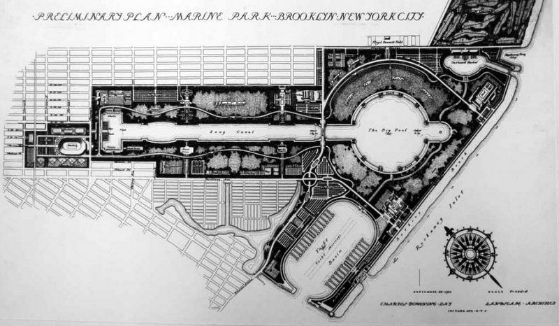
Charles Downing Lay, preliminary plan for Marine Park, Brooklyn, September 1931 (Carl A. Kroch Library, Cornell University)
In the same bay as Mau Mau Island, you can see wood pilings that were part of a grand park and athletic facility planned for Marine Park. The never-realized design by Charles Downing Lay even won the silver medal at the 1939 Olympics in Berlin when the event had a town planning competition. Lay hoped that the park would be “a park for the people of Brooklyn and all New York that shall be as beautiful as any private estate and finer than any park of its kind ever built.” As Thomas J. Campenella notes in the article, “Playground of the Century: A Political and Design History of New York City’s Greatest Unbuilt Park,” the failure to build this park ironically led to the preservation of the natural tidal landscape in Marine Park.
The park would have been more than 1,800 acres in size, larger than both Central Park and Prospect Park combined, writes Campenella, and that
“It would feature bowling greens, archery butts, bocce pitches, picnic groves, lacrosse and croquet fields, 200 tennis courts, eighty baseball diamonds, and three outdoor swimming and wading pools. There would be a skating rink, a zoo, an eighteen-hole golf course, thirty restaurants and cafeterias, a 1,000-seat casino with formal gardens, and an open-air theater and a music grove that, together, could accommodate 30,000 patrons. Regional access would be handled by a Marine Park stop on the proposed Utica Avenue elevated line. Circulation within the vast site would be facilitated by thirty miles of walkways and nine miles of road served by circulator buses”
In the style of the City Beautiful, much of the landscape would be significantly reshaped with artificial canals, large pools where yachts, racing boats, and pleasure boats would maneuver, and boat basins. There were also plans to build the largest football stadium in America, which would fit 125,000 people, along with impressive bathing pavilions that could host 12,000 people at a time. Lay also hoped that this park would also be an entertainment destination to rival Coney Island.
The grand plan was waylaid by corruption charges within Mayor James Walker’s administration and the plan and ongoing construction at Marine Park became a symbol of the waste, an easy target for new mayor Fiorello LaGuardia, in his quest to clean up New York City and Robert Moses, newly appointed as commissioner of the Parks Department. 5,400 workers were assigned to the Marine Park plan and were said to be mostly lounging around. In addition, Lay was not in a good position with Moses, having repeatedly opposed the master builder’s efforts on Long Island. Moses even had a nickname for him: “Landscaper Lay.”
5. The History of Dead Horse Bay

Just next to Floyd Bennett Field in Brooklyn sits Dead Horse Bay, whose macabre name aptly describes its history. Though the bay is technically within the Gateway National Recreation Area, it is close enough to Marine Park that we decided to include it here.
Dead Horse Beach was once a separate island known as Barren Island before the area was landfilled to create Floyd Bennett Field. In 1859, the first horse rendering plants were constructed on Barren Island, which processed dead horses by mashing them up, steaming them, separating the products and boiling the bones down into glue. The remnants became commercial fertilizer. This was seen as a better alternative to the ongoing practice, where horses were simply left to rot and decompose on New York City’s streets. Originally, Barren Island was considered ideal for this noxious activity because it was so remote, nobody would complain about the smell.
Later, Barren Island was also used to deal with the city’s garbage problem. Prior to the formation of the New York Sanitary Utilization Company, trash was dumped into the waterways. Motivated by financial reasons – the garbage was getting in the way of ship traffic – the city selected Barren Island for the processing and disposal of trash.
Similar to the horses, the trash would be boiled and steam cooked until a layer of grease emerged at the top to be skimmed off and sold for industrial lubrication and soap. But with encroaching development, even Barren Island became too close for comfort due to the smell. The stench, which could reach a radius of six to ten miles, would waft over to beachgoers on Manhattan Beach where hotel evacuations would occur.
Unsurprisingly, neighboring communities began complaining and locals formed the Anti-Barren Island League. The landfill ceased operation in the 1940s and was capped off in 1953, but the waste emerges on a daily basis due to erosion, leaving a beach of strewn bottles, old toys, and shoes.
4. Floyd Bennett Field Contains an Aircraft Restoration Facility

Opened in 1931, Floyd Bennett Field briefly served as New York City’s first municipal airport before its conversion to a naval air station during World War II. The field and its remaining airplane hangars are now a part of the Gateway National Recreation Area. In recent years, it has been the goal of the Historic Aircraft Restoration Project (H.A.R.P.) to preserve the aviation history of Floyd Bennett Field. Since 1996, H.A.R.P. volunteers have spent thousands of hours restoring vintage aircraft beneath the roof of Hangar B on the east side of the field. Today, Hangar B houses one of the finest aircraft restoration facilities in the United States.
Among the rescue planes, fighter jets, and bombers housed in Hangar B is the Douglas C-47 “Skytrain.” Widely considered to be one of the greatest aircraft ever built, the C-47 Skytrain was originally designed in 1935 as a commercial airliner. Flown by early U.S. carriers like American Airlines and Pan Am, the C-47 Skytrain was used for both short and long-haul flights. During wartime, a military version of the aircraft was designed and over 12,000 were produced. The C-47 Skytrain played a critical role in World War II and was the workhorse of the Allied air effort. Capable of operating on unpaved surfaces, it delivered airborne troops to the battlefields of Normandy, army mules to the jungles of Burma, and provided vital supplies to allied forces around the world. After the war, the C-47 Skytrain was flown by the military until 1975 before being retired. There are an estimated 2,000 still flying to this day.
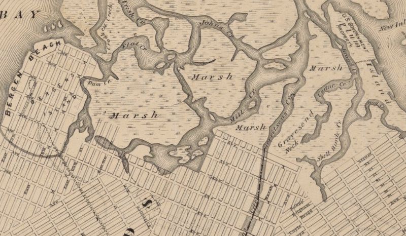
3. Gerritsen Creek Once Went Twice as Far Inland into Brooklyn
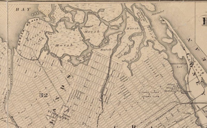
1898 “Map of the Borough of Brooklyn Published for the Brooklyn Directory” from NYPL Digital Collections. In this map south is at the top of the map, and north is at the bottom. Gerritsens Creek runs down the middle of the map.
Alyssa Loorya, an urban archaeologist and founder of Chrysalis Archaeological Consultants, serves as the Vice President of the board of the Lott House Preservation Association. She says that a location for the Underground Railroad stop at the Lott House makes sense. Gerritsen Creek, a freshwater stream, used to come up closer to the Lott House, which is en route to Weeksville, a neighborhood in Brooklyn founded by freed slaves in present-day Crown Heights. The 1898 “Map of the Borough of Brooklyn Published for the Brooklyn Directory” shows Gerritsen Creek reaches to nearly Avenue R.
As the NYC Parks Department reports, around 1920 “the creek north of Avenue U was converted into an underground storm drain. Yet it continues to supply the salt marsh with fresh water, which helps the marsh support a wide range of organisms.”
2. Archaeological Excavations in Marine Park Show Items Going Back to 800 AD
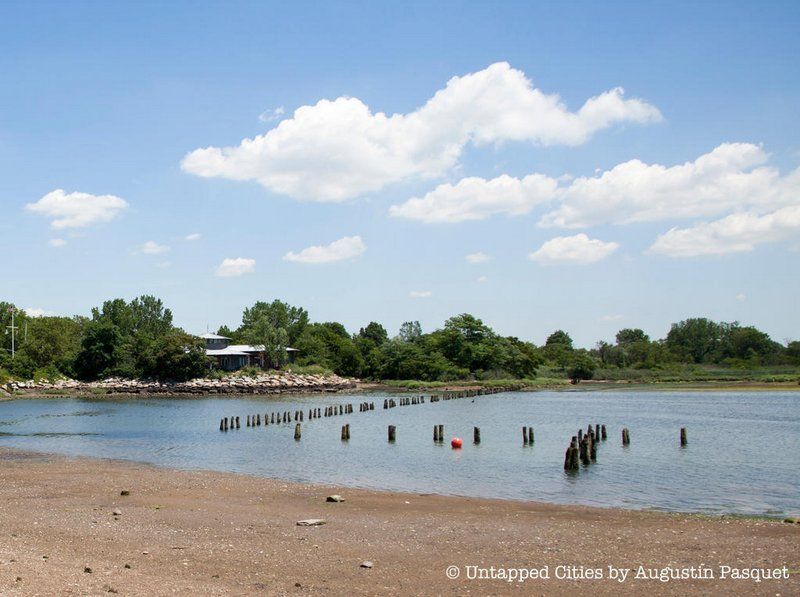
Remnants of the pilings from the Olympic winning plan for Marine Park and the Marine Park Salt Marsh Nature Center, behind which an archaeological dig was performed
Although portions of Marine Park were constructed of a more recent landfill, parts of Jamaica Bay were formed as far back as 5000 years ago through the deposition of sand by ocean currents along Long Island. Frederick Van Wyck, author of Keskachauge or The First White Settlement on Long Island believed that the Marine Park area likely contained “the most undisturbed traces of Native American occupation in New York City,” write Alyssa Loorya, H. Arthur Bankoff, and Christopher Ricciardi in a report about a 1997 archaeological excavation.
The dig was performed at the intersection of Flatbush Avenue, Burnett Avenue, and Avenue U in southern Brooklyn and revealed items dating from 800 to 1400 A.D. that include Woodland Period Native American items for food preparation. The findings included deer and turtle bones, oyster shells, and sturgeon scales.
1. Marine Park Was Once Known as Strom Kill
1898 “Map of the Borough of Brooklyn Published for the Brooklyn Directory” from NYPL Digital Collections.
In the Dutch era, the neighborhood that is now Marine Park was once known as Strom(e) Kill. Kill means riverbed or waterway in Dutch. It was later referred to as Gerritsen’s Creek, after the Dutch family that settled the area, and as Mill Pond. The area was marshy and the bay was filled with small islands. The name Marine Park was only conceived in the 1930s, following the development of the park.
Next, read about the Top 12 Secrets of Prospect Park.
