Last Chance to Catch NYC's Holiday Notalgia Train
We met the voices of the NYC subway on our nostalgia ride this weekend!


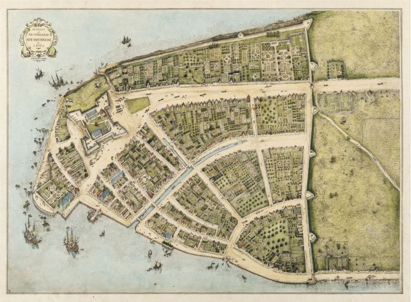
1916 Redrawing of The Castello Plan, map of 1660 New Amsterdam via Wikimedia Commons.
While our extensive subway system has become synonymous with New York City transportation, what is now Downtown Manhattan used to harbor a system of canals during the 17th century. In fact, relics of Dutch New Amsterdam can still be found south of Wall Street to this day, though corporate high-rises and zooming taxis can easily distract us from what’s situated right under our feet.
On our upcoming tour of Dutch New Amsterdam, we’ll retrace the streets of Manhattan in 1667 and discover remnants from that time period hidden in plain sight, including the remains of the Lovelace Tavern on 85 Broad Street and Stadt Huys, New York City’s very first City Hall. Along the way, we’ll also learn about some of our city’s lost canals, including the Heere Graft, the largest of such conduits, which once ran down what is now Broad Street from Pearl to Beaver Streets.
During the 17th-century, between the years 1646 to 1676, the Heere Graft emptied out into the East River. Both the Heere Graft and its “narrower continuation,” Prinzen Gracht,” which ran from Beaver Street to south of Exchange Palace, were named after canals that had recently been built in Amsterdam. Old Wells and Watercourses of the Island of Manhattan, by George Everett Hill and George E. Waring, Jr. in Historic New York: the First Series of the Half Moon Papers reports the following of the Dutch settlement:

… an inlet of the bay, which could be made to do duty as a canal, extended inland for about a quarter of a mile on the line of the present Broad Street. This ditch was the natural outlet for a marshy section of considerable size lying above what soon came to be known as The Beaver Path, now Beaver Street. A brook tricked through this marsh, from the common lying north of it, called the Shaape Waytie, or Sheep Pasture, and received the flow of a small stream which ran through the Company’s Valley, as that portion of the The Beaver Path was named which lay between Heer Straat (Broadway) and the junction of these two rivulets. From the latter point, the Heere Gracht — or Heere Graft as it was soon called, stretched its odorous length to the bay.
Unfortunately, the “odorous length” was akin to a sewer and the English, upon acquiring control of the land, ordered the Heere Gracht to be filled in in 1676. However, you can still see it depicted on various maps of the Dutch settlement, including the following Dunreath Publishing Co. map, circa 1897. (Here, Broad Street was called “The Common Ditch.”)
 Map via Wikimedia Commons.
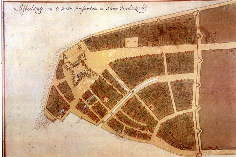
Below is the Castello Plan, the original city map of New Amsterdam created by Jacques Cortelyou in 1660. You can spot the inlet with three bridges spanning it:

Castello Map from Wikimedia Commons
And at the top of this page is a redrafted version of the same map, created by John Wolcott Adams and Isaac Newton Phelps Stokes in 1916.
Interestingly, as Untapped Cities tour guide, Justin Rivers tells us, Bridge Street is actually named after a bridge that once ran over the canal. Thanks to its history as a waterway, Broad Street also remains one of the widest streets in Lower Manhattan.
For more history about the neighborhood, join us on our next tour of the Remnants of Dutch New Amsterdam, which takes place this weekend:
Next, check out 10 Things the Dutch Introduced to NYC and America from Bowling to Santa Claus to Democracy and Why is Manhattan’s Oldest Public Park Named Bowling Green?
Subscribe to our newsletter