Last Chance to Catch NYC's Holiday Notalgia Train
We met the voices of the NYC subway on our nostalgia ride this weekend!


The Bronx is a borough rich with intriguing history and culture, with hallowed arts, sports, and wildlife institutions making it one of the most increasingly developed boroughs in New York City. While many of The Boogie’s Down’s landmarks have been well-maintained, some have not been so lucky.
Many buildings and structures throughout the northernmost borough of New York City have fallen into disrepair and now lay abandoned throughout the Bronx. Once bustling transportation hubs, government institutions, military armories have since become shells of what they once were. While many of these spots seem to be destined to remain in the shadow of their former glory, others have been given a chance at a new life with projects to restore, revitalize, and largely re-imagine the areas they occupy.
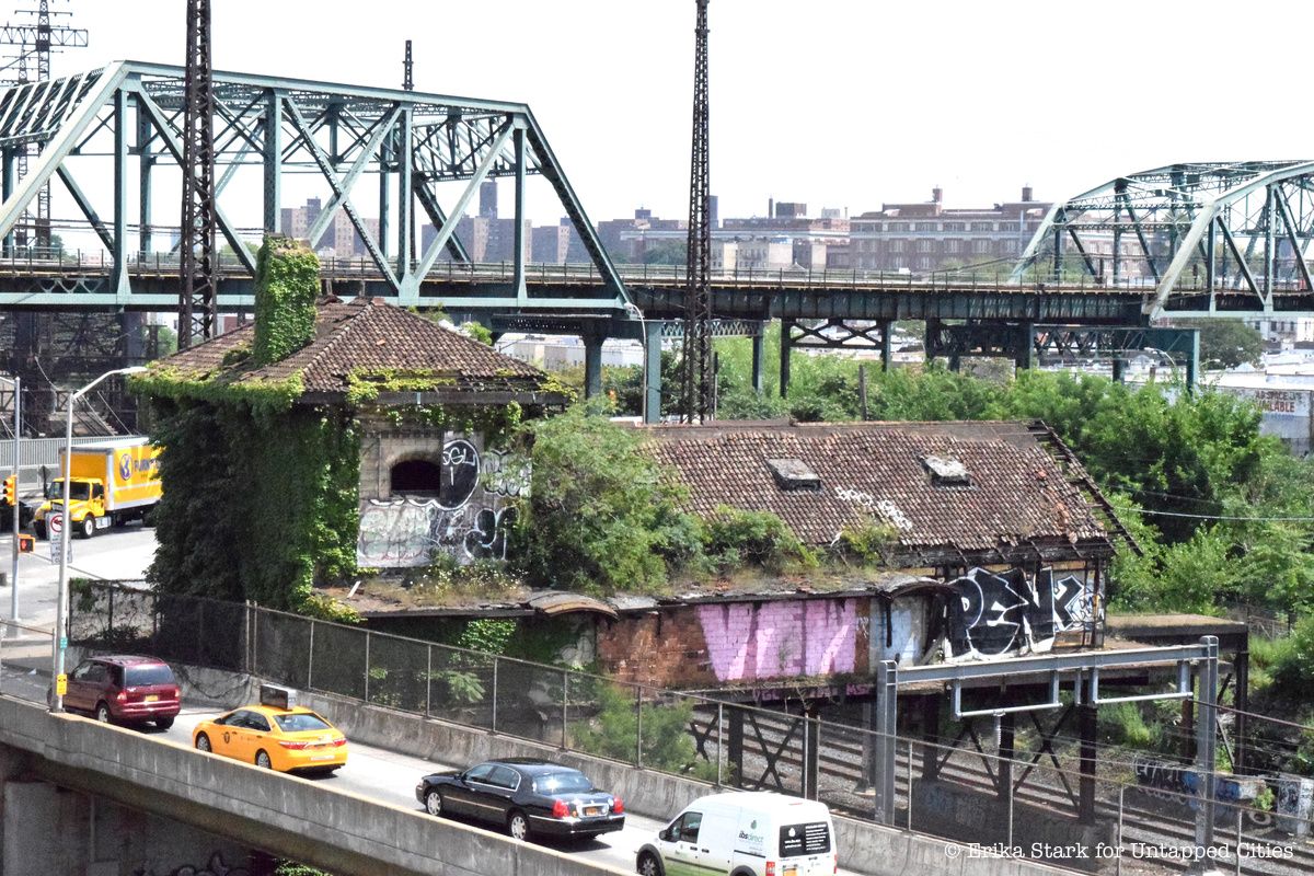
The Westchester Avenue Station along Concrete Plant Park in the Bronx, which is just off the Whitlock Avenue stop on the 6 train, has now become overgrown with plants and vines. In its heyday, however, the Westchester Avenue Station was a transportation hub for those travelling on the New Haven Railroad, known as the NYW&B. Unfortunately, the NYW&B went bankrupt in 1937, stopping travel through this area.
The station, designed by Cass Gilbert, was an important work of gothic architecture. Gilbert, also the designer of Lower Manhattan’s US Custom House, was commissioned to build 13 stations, including Westchester Avenue, for the railroad in 1908. This station is among four from this commission that remain, along with Hunts Point Avenue, City Island and Morris Park, though all had fallen into disrepair by 2009. While other stations have projects planned for revitalization of the building, Westchester Avenue Station’s fate has yet to be determined, and remains on the New York Landmark Conservancy’s endangered buildings list.
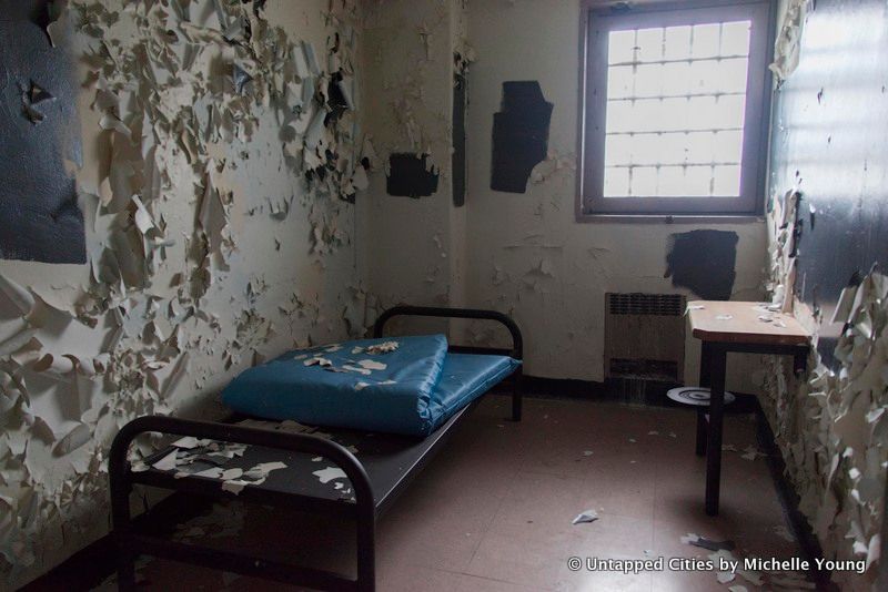
The Spofford Juvenile Detention Center in the Hunts Point neighborhood of the Bronx was closed in 2011 after community activists and criminal justice advocoates cited its poor living conditions and treatments of detainees. The detention center was renamed the Bridges Juvenile Detention Center in 1999. Its multi-wing complex once held as many as 289 juvenile detainees. The detention center featured several recreational facilities like basketball and tennis courts and a pool. It also held a state-approved school called the Carter G. Woodson Academy.
When Spofford closed in 2011, everything was simply left behind, giving the building the appearance of being frozen in time. Mattresses, files, deflated basketballs, and a single black sneaker are among the pieces remaining in the abandoned detention center. The building will not stay like this for long, however. Last year, the New York City Economic Development Corporation (NYCEDC) announced their intention to transform Spofford into a five-acre affordable live-work campus. Spofford will be demolished to make way for this project, to be named “The Peninsula.”
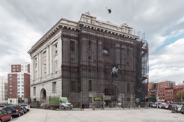
The Old Bronx Borough Courthouse at 878 Brook Street in the South Bronx was built between 1905 and 1914 and is an official New York City landmark. It functioned as home to Supreme, Surrogate’s, and County Courts until the 1934 opening of the Bronx County Courthouse, built to accommodate the borough’s growing population. The Beaux-Arts structure, while covered in scaffolding on its exterior, has a grand interior with marble and iron detailing.
The four-story building was shuttered for 37 years before reopening its doors in 2015 for a series of public art programs put on by No Longer Empty entitled When You Cut Into the Present the Future Leaks Out. Three floors of the Old Bronx Borough Courthouse were filled with contemporary art. Twenty-six local artists came together to create works which drew from the history and structure of the borough.
The building will find a new life in 2018 as a charter school, as the entire property has been leased Success Academy High School of the Liberal Arts for the next 20 years.
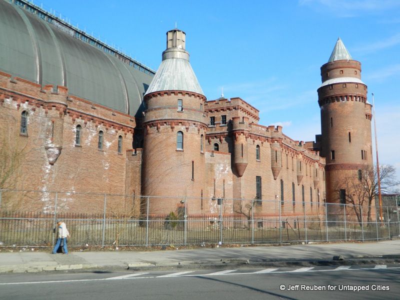
The Kingsbridge Armory on Kingsbridge Road in the Bronx was been vacant since 1995. The 575,000 square foot building, once used to house the National Guard’s Eighth Coastal Artillery Regiment, has not been used for military purposes in more than 20 years. It has, however, been used for several other purposes, including the filming of the 2006 Will Smith film, I Am Legend.
In 2013, Mayor Michael Bloomberg and the New York City Economic Development Corp. unveiled an initiative to transform the Kingsbridge Armory in the Bronx into the world’s largest indoor ice facility. The plan, to be called the Kingsbridge National Ice Center (KNIC), will include 9 regulation ice rinks spread across multiple floors of the building. The $275 million project has had trouble getting financed within the last few years, though Mayor De Blasio this year offered assistance to get the project off the ground.
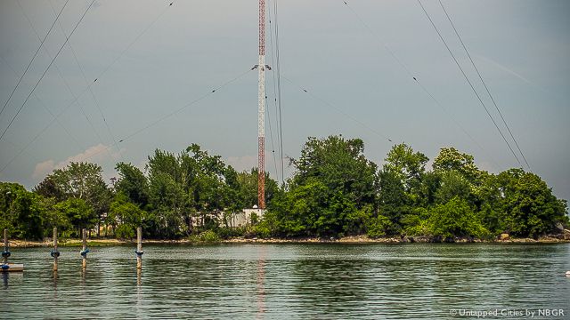
Chimney Sweeps Islands and High Island are part of a collection of 20 islands on the border of Bronx County known as the “Devil’s Stepping Stones.” This name finds its origin in Native American folklore, which stated that a land mass formed whenever the Devil set his foot on the water. The name of these islands also references how barren they are, composed of a significant amount of bedrock and little vegetation.
The Chimney Sweep islands have never actually been inhabited by people, but instead bird populations such as seagulls and blue herons. High Island once had a short-lived human dwelling, before they were displaced for the construction of a radio transmission tower in 1962, which had to be reconstructed a few years later when a small plane crashed into the tower in 1967.
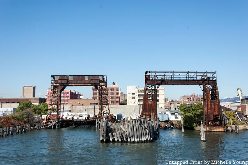
The Port Morris area of the Bronx, an industrial section of the borough located near New York City’s railroad yards, is home to several gantry cranes which were used for loading and unloading ferries. These gantries, though widely used during their time, fell out of use in the 1960s and have been abandoned ever since.
Since 2014, however, efforts have been made to revitalize the Port Morris gantries. This initiative, led by the South Bronx-based organization Friends of Brook Park, would place the gantry in the center of a newly-constructed park. This is one of many efforts for New York City’s gantries to be revitalized as anchors for parks, among them the 69th Transfer Bridge and Long Island City Gantries
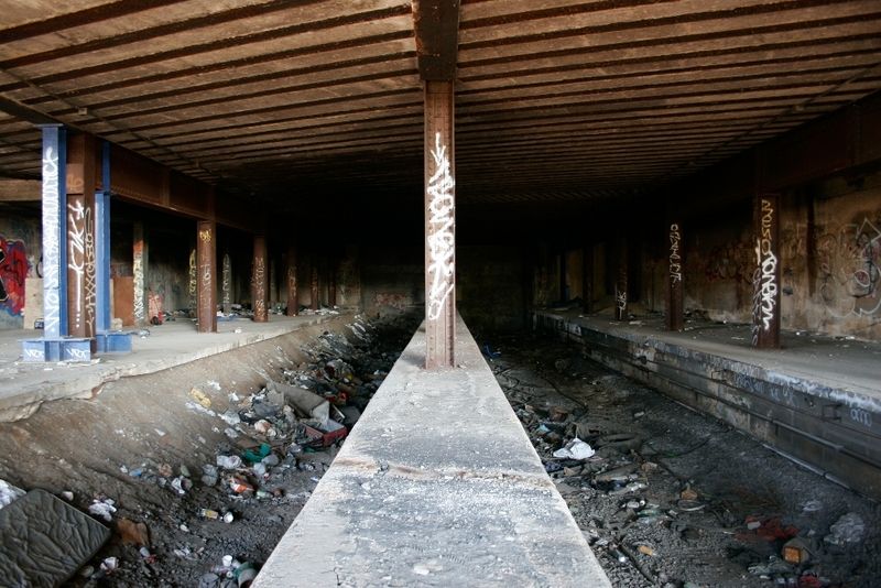
Abandoned Sedgwick and Jerome-Anderson station in the Bronx. Image via Vanshnookenragen
The abandoned Sedgwick and Jerome-Anderson station in the Bronx , one of many in the city that have been decommissioned, first opened in 1918. It was once a part of the Ninth Avenue El, which was the first elevated railway in New York City history. The station closed in 1958.
While most of the stops on the line have since been demolished, pieces of the tracks at the Sedgwick and Jerome-Anderson station still remain in ruins. Access to the Jerome-Anderson side of the station is extremely limited today as the elevated platforms are gone, so a bit of climbing is required to see some of the best portions of the abandoned tracks. However, the Segswick side of the platform is more visitor-friendly as it is accessible via footbridge.
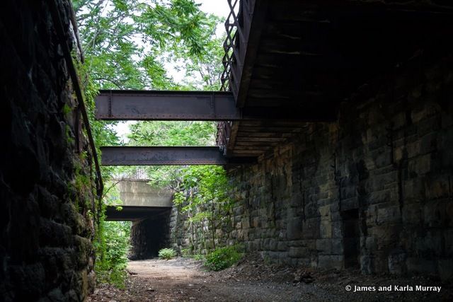
The Port Morris Line Train Tracks in the Bronx were built in 1842. They were once nicknamed the “Mott Haven Swamp” for the water accumulated in the rail corridor, though the Department of Environment Protection removed 625,000 gallons of water from a one-mile section of the corridor in December of 2009. The city has since made renovations to the area so people can pass through the tracks. The track beds were vandalized by graffiti in the 1990s and early 2000s and have been filled with many homeless encampments in recent years.
Last year, photographers and authors James and Karla Murray shared their photos of their adventures through the Port Morris Line Train Tracks, which they visited before and after the draining of the corridor. Though the EPA’s efforts made it area more accessible, it was still largely littered with trash and rubble. In recent years, there has been talk of converting this area into a “Lowline Park.”
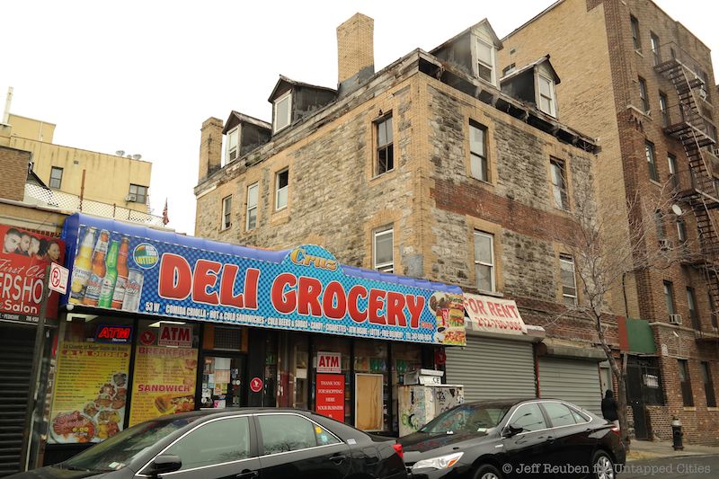
On the corner of West 167th street lies an abandoned stone mansion building, with many windows and chimneys. However, it is inaccessible due to a chained door. The only peek into the building’s interior is through open windows which reveal that it has fallen into disrepair. The building, composed of multi-brick and stone, is surrounded by an apartment complex and smaller shops.
According to Scouting NY, this mysterious building was once a parsonage for the Union Reformed Church in use from 1888 until 1925 when it was moved to its new location north of 168th Street.
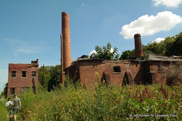
North Brother Island, 22 acres off the coast of the South Bronx, has been abandoned for more than 50 years. Known as a former quarantine facility that housed infected patients – including Typhoid Mary – it is today in a state of decay. North Brother Island was shut down in 1963, though residents of the Bronx often headed to this area to party, something that has been cracked down on in recent years because of several dangerous incidents. Though the island is no longer occupied by humans, it is home to many bird populations and has been taken over by large amounts of vegetation.
NY1 recently toured this area and created a video with interesting shots of the area while detailing some of the island’s history. This video can be viewed here.
For more Abandoned NYC, check out 12 Abandoned Places to Discover in Brooklyn, NYC and 11 Abandoned Places to Discover in Queens, NYC
Subscribe to our newsletter