Last-Minute NYC Holiday Gift Guide 🎁
We’ve created a holiday gift guide with presents for the intrepid New Yorker that should arrive just in time—


For those of us who travel frequently between Manhattan and Brooklyn or the East and West sides, the closure of the L train may sound like the stuff of nightmares. Yet it may not be as bad as it seems. As New York City dwellers, and more importantly as commuters, it’s important to know what’s happening, what the travel alternatives will be, and how such a project will affect all of our daily lives.
The first thing to know is that the Canarsie Tunnel was built in 1924 and now supports about 400,000 daily riders, which means that its infrastructure is definitely in need of an update and that its renewal will affect an enormous amount of people. In addition to this, nearly seven million gallons of saltwater flooded the tunnels in 2012 during Superstorm Sandy, causing damage to electrical equipment, concrete structures, and tracks. While the subway system is certainly safe for use, it is clear that reconstruction and renewal are desperately needed and, as a result, the L train will be closed.
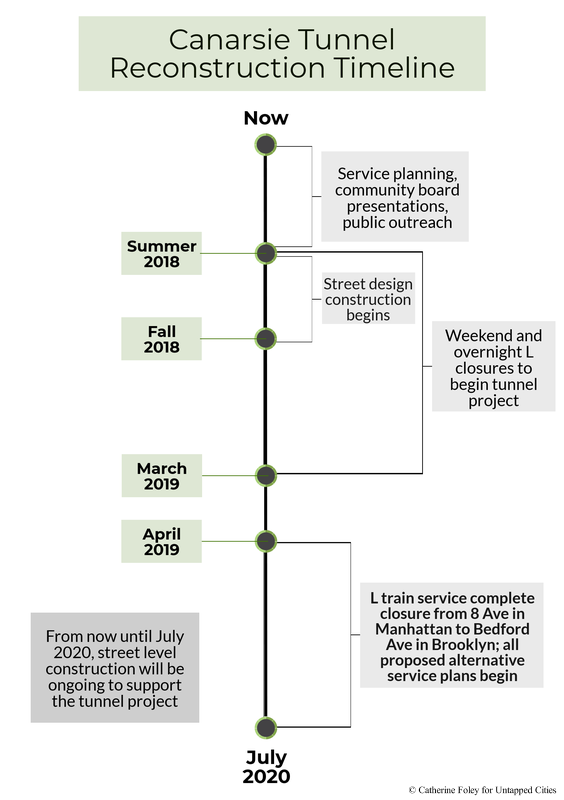
Although the complete closure of the L train line (from 8th Ave in Manhattan to Bedford Ave in Brooklyn) will not occur until April 2019, several aspects of the reconstruction have already begun and will continue until July 2020. Below is a timeline of the major changes that are occurring now until the completion of the project.

The Canarsie Tunnel project requires an immense amount of work in the tunnels, but its reconstruction will provide users with newer, cleaner, and safer systems. In particular, the renewal will focus on:
In addition to tunnel closures and construction, there will be a Union Square West/University Place project and an enhanced bike network project that will allow for greater pedestrian areas and biking lanes.
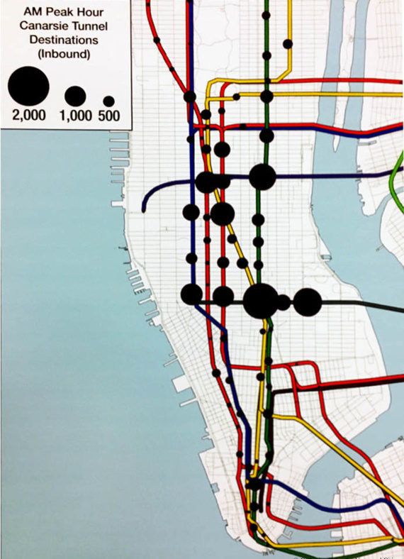
The closure of the L train service will obviously affect thousands of travelers, but the MTA/DOT has several plans for alternative travel options that will remedy areas of congestion and allow people to get to their destinations on time. Below is an estimate by the MTA of activity during peak hours along the L train route as well as other major subway stations. It’s evident that L train stations support the highest amounts of traffic during peak hours, thus multiple methods of transportation will be provided during the closure.

Image courtesy of MTA/DOT
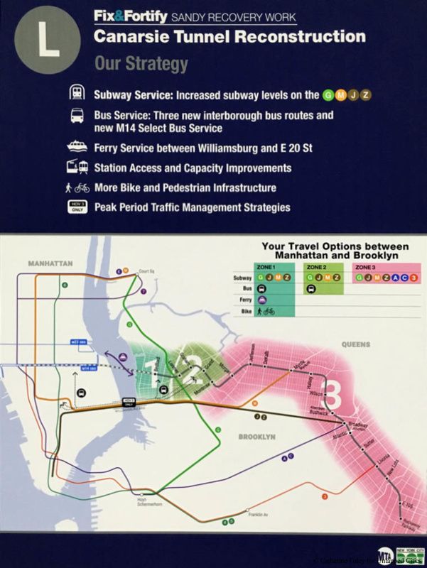
The MTA/DOT has ensured that free out of system transfers will be available to travelers, meaning that tickets will be cross-honored for same day travel on the ferry, bus, and subway. In particular, transportation options will be bolstered in six specific areas in order to accommodate all possible commuter routes.
These new alternatives are:

Image courtesy of MTA/DOT
The MTA/DOT is making efforts to ensure that these alternate routes can sustain the many new commuters, particularly in terms of the frequency of services. During rush hour, buses will run every 3 minutes, ferries will run eight times an hour, and the number of trains running on alternate subway lines will also be increased. According to the MTA, there are three zones along the L line in Brooklyn which will be affected by the closure; the first zone being the most affected and the third zone being virtually unaffected.
Lastly, the rumor of a new L train stop in Alphabet City has unfortunately been proven false, there will be no additional stops added during the reconstruction. It’s disappointing but such a project would have added even more time to the closure, so it’s for the best that we get this over with as quickly as possible!
Learn more about the Canarsie Tunnel Reconstruction project and travel alternatives by visiting one of the MTA/DOT open houses on February 8th, 2018 or February 14th, 2018.
Next, check out these sliding platform screen doors that may come to L train stations, discover the secrets of the NYC subway system, or take an underground tour of the subway!
Subscribe to our newsletter