Last Chance to Catch NYC's Holiday Notalgia Train
We met the voices of the NYC subway on our nostalgia ride this weekend!


Queens Boulevard, a predominantly twelve-lane thoroughfare that extends from Queens Plaza off the Queensboro Bridge to Jamaica, may not be the most illustrious of roads. It’s so functional, it’s not seen as a destination in itself. It can even be dangerous: the number of pedestrian deaths garnered it the nickname “Death Boulevard.” Between 1990 and 2017, 186 people were killed either walking or driving on Queens Boulevard. Improvements by the New York City Department of Transportation, including reducing vehicle lanes and increasing cross walk times, have reduced the frequency of incidents.
All this aside, an exploration along Queens Boulevard is in fact, particularly interesting because of its long span. It stretches seven-and-a half miles southeast traversing through the borough’s most dense areas. It is quite the demographic discovery as well, beginning in rapidly developing Long Island City through Sunnyside, Elmhurst, Rego Park, Forest Hills, Kew Gardens, and ending in Jamaica.
This is not surprising, given that Queens Boulevard actually follows the path of earlier laid roads, Thomson Avenue and the Old Jamaica Road from the 18th century, that were important as travel thoroughfares in the early days of settlement in Queens.
If you are up for a discovery, perhaps achieved most efficiently by bus, or going to visit these places in batches, here are ten of our favorite finds along Queens Boulevard:

Embedded in the ground at a traffic median in Woodside, Queens along Queens Boulevard is a compass rose with the words, “The Geographic Center of NYC.” It sits mostly forgotten at the intersection of 58th Street and Queens Boulevard between a Walgreens and Calvary Cemetery, but the design seems pretty official. The cardinal directions are marked, and the number 58 seems to refer to the intersection. It would have taken some effort to get this installed. The only problem: it is NOT the geographic enter of New York City.
You can explore a previous deep dive of this marker on Untapped New York, as we attempted to ascertain the mysterious origin of this incorrect marker, which no city agency has taken credit for. In fact, we have a recent update thanks to a reader who has helped locate the metal shop on Long Island in which the marker was made, the person who made it (who has since passed away), and dates it to no earlier than 1994 due to evidence in a photo documentation he acquired.

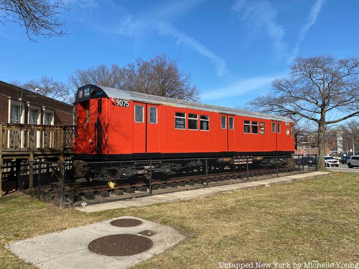
From 2008 to 2015, an old Redbird subway car operated as the Queens tourist center on short length of rail next to Queens Borough Hall in Kew Gardens. Its closing was ordered by then-Queens Borough President Melinda Katz, due to low visit numbers. The majority of the visitors to the center, according to sole employee, Roxanne Solarsh, were on their way to Queens criminal court just next door and were often just curious about the center’s unconventional digs. (Fun fact: the exterior of the Queens Detention Facility nearby is often used as a stand-in for Rikers Island on television shows, and you may have caught it on The Night Of and Mr. Robot.)
Though closed, the Redbird is still sitting there and you can still go up onto the wooden platform that runs the length the subway car and peer inside. It still has the long gray bench seats and a few old advertisements, including one for World Health Day in 1977 and one for Pampers diapers. The directional signs on the exterior say 7 train to Main St. Flushing.
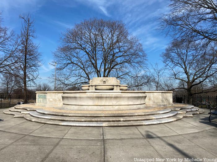
Long before the project to add more female figures in New York City’s sculptural works or to remove sculptures of those connected with less savory parts of history, the Civic Virtue Triumphant Over Rightousness statue may have been the city’s most controversial. The allegorical piece was commissioned in 1909 and installed in 1922 and installed in Manhattan’s City Hall Park, as part of a fountain. The statue is 22 tons of marble carved from a single block, meant to represent the triumph of virtue over corruption and vice.
 Civic Virtue in its newest home
The problem: the nearly naked male figure is triumph, towering and dominating over the two female mermaids who represented corruption and vice. Women found this misogynist and offensive, and even men thought it looked like the virtue was kicking or trampling the female figures. By 1929, James J. Walker, the Commissioner of Public Works was calling the sculpture “the Fat Boy standing in a mass of worms,” and advocated for its removal. The statue was finally moved in 1941 to Queens Borough Hall. It was not well-liked in Queens either, with Anthony Weiner even suggesting to sell the statue on Craigslist.
In 2011, Green-Wood Cemetery President Richard J. Moylan offered to give the statue a home in the cemetery. By early 2013, Civic Virtue was placed among other statues by sculptors contemporary to MacMonnies, like Daniel Chester French and John Quincy Adams Award. The cemetery even funded its renovation. After 90 years, Civic Virtue seems to have found its resting place. The fountain portion remains, however, along Queens Boulevard.
 A glimpse of the aircraft parked in clear view behind the Aviation High School in Queens.
Did you know there is an Aviation High School in New York City? The Aviation Career & Technical Education High School in Queens is located on Long Island City at 45-30 36th Street and shares a northern boundary with Queens Boulevard. You’ll find vintage airplanes in the courtyards of the high school. Formerly known as the School of Aviation Trades, the Aviation High School looks almost identical to the way it did when it opened in 1954 but the history of the school begins even earlier in 1930, when the aviation program was developed.
The focus of the school makes sense geographically — aviation was big business for Queens and Long Island following the Second World War. The high school was specifically designed with the growing demand for experienced aviation workers in mind. As of 2014, 12 percent of all the aviation mechanics in the United States graduated from the Aviation High School in Queens, where they completed the school’s Federal Aviation Administration (FAA) certified program.

The largest cemetery in the United States is located along Queens Boulevard between Sunnyside and Woodside. Calvary Cemetery, an über-popular film location, is the final resting place of over 3 million people. It is bounded by Queens Boulevard on the north and extends down to to 55th Avenue south of the Long Island Expressway.
Calvary Cemetery has appeared in numerous films and television series, including Zoolander, Gotham, The Night Of, Jessica Jones, Daredevil and much more. Read more about the secrets of Calvary Cemetery here.
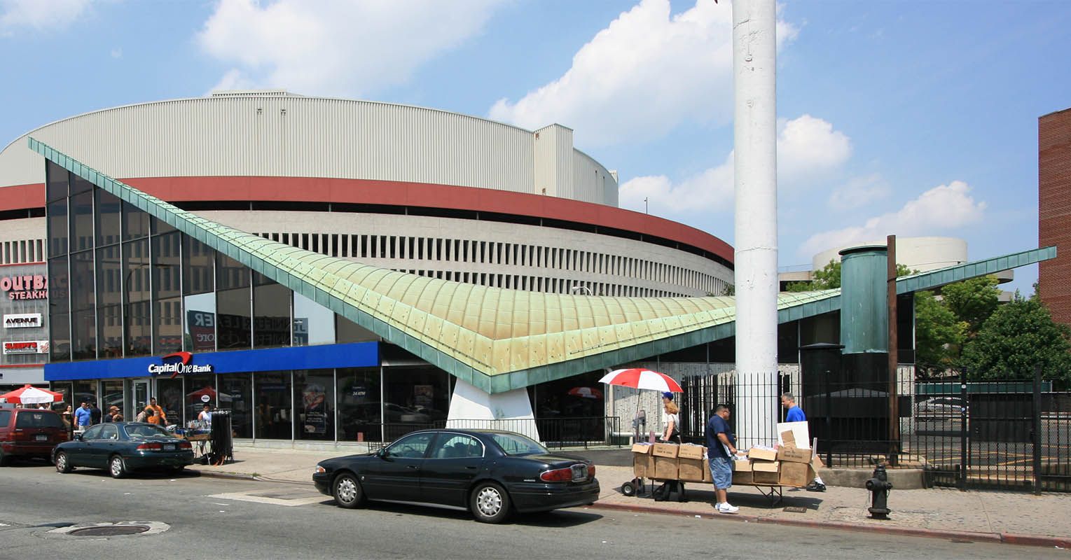
Photo by Michael Perlman/Rego-Forest Preservation Council
Quite forgotten in the shadow of the UFO-like Queens Place, amidst the bustle of Queens Boulevard is a Modernist gem of a building. Once you notice it, it’s impossible to not see it as a relic of jet-age design, with its parabolic, wing-like copper roof that evokes something of the TWA Flight Center or the lost terminals at JFK Airport. In the mid-century, Modernism was certainly in the air in Queens, not only at the airport but also with the arrival of the World’s Fair at Flushing Meadows-Corona Park in 1964-65.
The building at 89-01 Queens Boulevard in Elmhurst was built from 1964 to 1966 as the Jamaica Savings Bank. In a strange and unusual twist of events, the bank is one of five buildings in the history of New York City to have its landmark status revoked. A new movement to preserve the building is underway. Read more about the bank here.
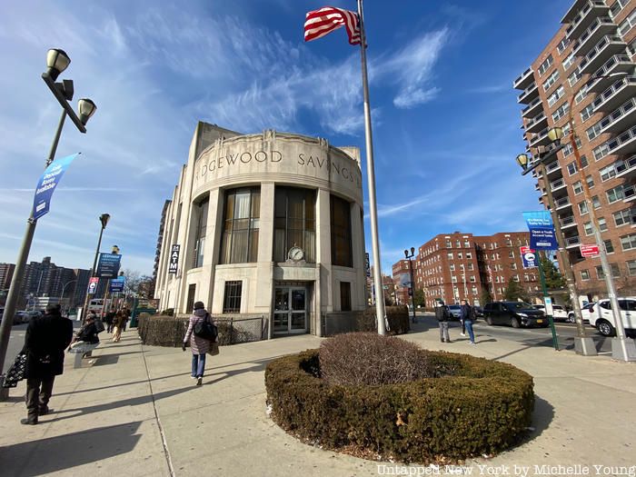
Not far away in Forest Hills is the delightfully preserved Ridgewood Savings Bank at 107-55 Queens Boulevard. Inside, you’ll still find the old, copper colored teller booths and stained glass windows that you would have found on its grand opening day, when it was the first branch office for the bank.

The Modern Classical style bank is a designated New York City landmark, called “a unique and noteworthy presence on bustling Queens Boulevard,” by the Landmarks Preservation Commission, so you can expect this building to stand the test of time.
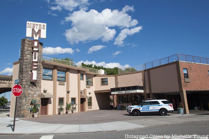
When a television series needs a location for a seedy motel, look no further than the Metro Motel, a show that has shown up on The Deuce and Billions. In The Deuce, it was a stand in for a motel on the New Jersey side of the Lincoln Tunnel where prostitutes would take their clients.
Appropriately, the motel also has pretty horrific Yelp reviews so just take this in as a filming location curiosity rather than an actual place to stay (note NYPD presence on our visit to photograph it).

Big things are afoot for Sunnyside Yards in Long Island, the latest target of a decking project, akin to those underway at Hudson Yards and Atlantic Yards in Brooklyn (now Pacific Park). The area is currently undergoing a master plan process led by the City of New York and Amtrak, with town halls taking place last fall. If completed, it would represent one of the largest new developments in New York City, with 180 acres up for grabs.
The Yard is currently used by the Long Island Railroad, New Jersey Transit and Amtrak, servicing any train that terminates at Penn Station. If you have taken a train out to Long Island or Amtrak in and out of New York City, you’ve been through here. It sees extremely high traffic at 780 trains per day. Nearby is also the Montauk Cutoff tracks which was officially been decommissioned in 2015.
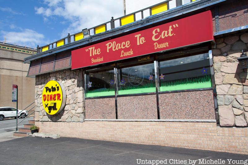
You can find one of the city’s last free-standing diners on Queens Boulevard in Sunnyside. Pete’s Diner & Grill, and it realy is open 24 hours a day, 7 days a week. Inside you’ll find that classic diner look and large portions of food, and large, stiff alcoholic drinks. Its tagline is simply, “The Place to Eat.” Like many locations on this list, it’s also a popular place for film locations seen in The Punisher and Homeland.
Next, check out 11 of the NYC’s Last Free-Standing Diners.
Subscribe to our newsletter