Last-Minute NYC Holiday Gift Guide 🎁
We’ve created a holiday gift guide with presents for the intrepid New Yorker that should arrive just in time—
We’ve created a holiday gift guide with presents for the intrepid New Yorker that should arrive just in time—

From lobster traps to origami animals, discover how quirky trees are decorated across the five boroughs!


The West Side Highway, also known as the Joe DiMaggio Highway, extends from West 72nd Street along the Hudson River to the southern tip of Manhattan. The West Side Highway replaced the rather problematic West Side Elevated Highway, which was shut down in 1973 due to disrepair. Completed in 2001, the highway was partially damaged as a result of the September 11 attacks. The highway has had quite the storied past, with lots of debates especially concerning the proposed Westway, which would have replaced the West Side Elevated Highway. Today, most people know the highway more for its cultural sites along the route, including the Whitney Museum and Hudson River Greenway. Here are 10 secrets of the West Side Highway, including some on its contentious past.
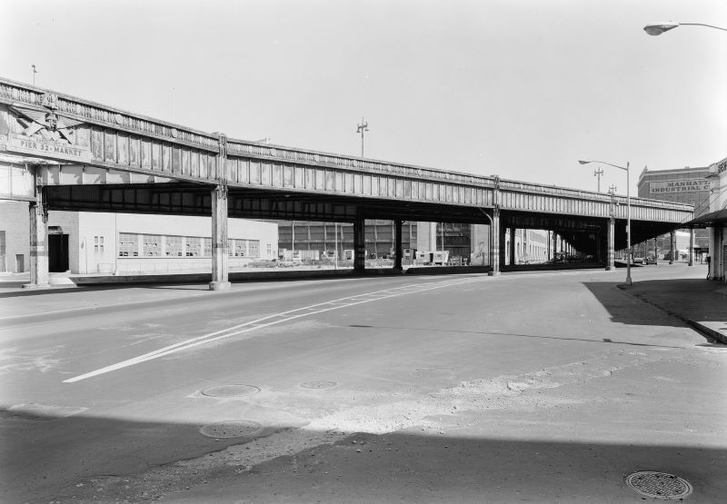
In 1925, the New York Central Railroad proposed building a highway and rail double-decked highway from 72nd Street to Canal Street, which would eliminate 106 grade crossings over 84 blocks. However, this idea was shot down due to concerns that the railroad would monopolize freight and raise prices. Instead, borough president Julius Miller proposed an elevated single-decked highway that would be wide enough for six lanes of traffic, extending the same distance as the double-decked highway plan. About 100 meat and poultry dealers were evicted from nearby markets to make way for the highway, which opened in 1929.
Although the city ultimately went ahead with the Miller plan for the elevated highway, there were a number of other ideas that gained some traction as well. Engineer John Hencken proposed a 10-story complex with a rail line underground, a road at street level, and a people mover on top (that could reach up to 21 miles per hour), topped by ten stories of apartments and offices. On top of the 10-story buildings would be the highway, accessible via ramps or elevators. A Swarthmore professor named Benjamin Battin had a similar idea for an eight-story high boulevard. Each floor would be able to carry cars and passengers traveling in different directions, with rush hour traffic occupying the top levels.

The West Side Highway was rather problematic even from 1929; lanes were considered too narrow and could not accommodate trucks, and sharp exit ramps often led to accidents. But in came Robert Moses to save the day — or so he thought. Moses built massive roadways extending both north and south of the West Side Highway, including the Henry Hudson Parkway and Brooklyn-Battery Tunnel, and he proposed straightening the West Side Highway and constructing the Lower Manhattan Expressway and the Mid-Manhattan Expressway. Neither were ever built, and after the northbound lanes between Little West 12th Street and Gansevoort Street collapsed under the weight of a dump truck, the highway shut down for 16 years before ultimately being demolished in 1989.
The proposition to replace the West Side Highway with the Lower Manhattan Expressway would have “barreled through parts of Greenwich Village and SoHo and shattered both communities,” according to Phillip Lopate in his book Waterfront: A Walk Around Manhattan. He continued, “The Lower Manhattan Expressway proposal seemed the apotheosis of everything seignorial and urbicidal in Moses’ method of planning; and the relative ease with which it was defeated signaled that a new day of community activism had arrived.”
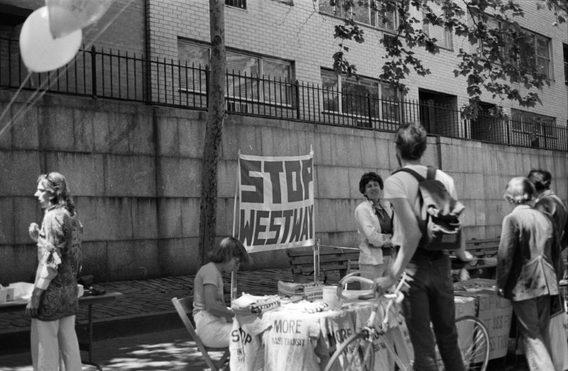
Governor Nelson Rockefeller championed a replacement plan, known as the Westway, that would have buried the six-lane highway in 220 acres of new landfill south of 40th Street, placing the new development on land instead of on raised platforms. The project would have cost a whopping $2.1 billion, and it even received support from President Reagan’s Department of Transportation. According to Phillip Lopate in Waterfront: A Walk Around Manhattan , “Part of what made the Westway plan so costly was that it offered far more than just a highway, encompassing a park and commercial and residential development as well.” Lower Manhattan’s flattened growth and the need for a sudden economic boost were tempting for many in the area. Yet many also objected to the project, noting that the proposal was essentially “the return of an old monster they had already slain.” Jane Jacobs staunchly opposed the project as well.
In 1977, the EPA issued a report showing that Westway was environmentally unsatisfactory and subsequently called for the trading of highway funds for mass transit. However, anti-Westway activists could never concretely prove that Westway would worsen air quality. Judge Thomas Griesa of the U.S. District Court, though, asserted that the road would harm striped bass, blocking the Army Corps of Engineers permit. According to Lopate, “The many enemies of an unbuilt Westway proliferated, however, in part because it remained an abstraction, a clumsy giant born of theory, unable to defend itself from charges of unreality.”
On September 30, 1985, after massive debates and legal disputes, New York City officially gave up on the project, allocating 60 percent of its interstate highway funds to mass transit. The remaining funds of $811 million were allotted for the “West Side Highway Replacement Project.”
For anti-Westway activists, this was a major victory for the city, since subway stations were improved and new trains and computerized monitoring equipment were purchased. And much of the praise (or aggravation) for defeating the project can be attributed to Marci Benstock, “an inspiration to environmental activists everywhere—and a paranoid zealot who does not know when to stop fighting.”
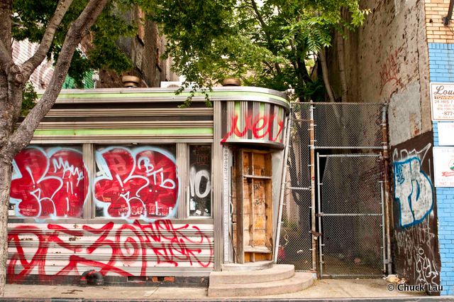
Abandoned between auto repair shops and a gentlemen’s club, the lost diner at 357 West Street, which stood for years and drew comparisons to Edward Hopper’s Nighthawks, closed in 2006 after 50 years of operation. It went through a steady succession of owners and names, including the Terminal Diner, the Lunchbox Diner, Rib, and perhaps most fittingly, the Lost Diner. Constructed by the New Jersey-based Kullman Diner Car Company, the structure was typical of the Art Deco diner cars manufactured in the 1940s and ’50s, which have since become an iconic fixture of cities across America.
In the dining room, shattered glass joined a host of reflective surfaces, causing the room to glimmer with points of light in the evening. Food piled up behind its front door under a Zagat rating. Old mattresses, fresh garbage, and a homemade toilet pointed to a recent habitation. In the former kitchen, a dry erase board listed celery seed, walnut oil, and Windex for a shopping trip that was doomed to be this diner’s last… The abandoned structure was destroyed in place of a residential tower designed by Herzog & de Meuron.
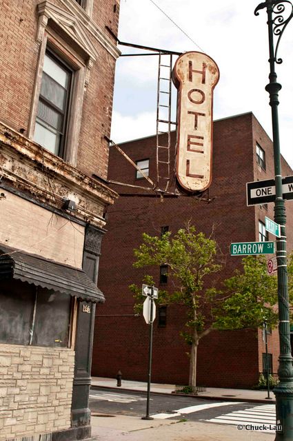
Located across from the Hudson River at 150 Barrow Street, the Keller Hotel was designed by Julius Munckwitz, an architect best known for designing the Central Park Boathouse. It was originally built in 1898 as the Knickerbocker Hotel, which catered to seamen and travelers aboard cargo and cruise ships. As the maritime industry began to falter, though, the hotel was registered as a home for itinerant seamen in 1935. It was converted to single-room occupancy housing in the 1980s, then a welfare hotel in the 1990s.
The Renaissance Revival-style building was designated a New York City Landmark in 2007 after remaining vacant for nine years. The Landmarks Preservation Commission threatened its owners in 2014, though, for failing to maintain it. But in 2017, Morris Adjmi Architects began to restore the facade and add a new story and cornice while keeping the iconic “Hotel” sign. In 2020, new permits for the site were filed by BKSK Architects to convert the hotel into condominiums.
On an unassuming corner of West Street and 15th Street, the Liberty Inn is an oddly-shaped triangular building and a remnant of the Meatpacking District‘s former days as a shipping port and seafaring center. Built in 1906 by poultry wholesalers as the Strand Hotel, the hotel got its current name in 1969. The hotel features a red awning with ‘LIBERTY’ scrawled across the front in a faux-cursive type. It occupies its own block on the Hudson River, and it is no more than three feet wide at its thinnest point.
The Liberty Inn is an hourly hotel, meaning it rents its rooms out at an hourly rate as one of the city’s last “romance hotels.” The hotel contains upscale Amour rooms with dramatic ceilings, wall murals, and colorful lights, while Romantic Interlude rooms feature a two-person jacuzzi tub. Until 1986, the hotel housed The Anvil, a gay club on the first floor. Now, the Liberty Inn is within walking distance to The Whitney, Chelsea Market, and many other popular Chelsea spots.
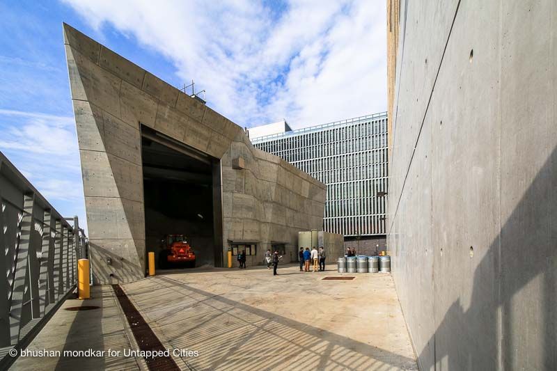
Adjacent to the New York City Department of Sanitation‘s contemporary garage on Spring Street is a 70-foot crystalline-shaped salt shed designed by WXY Studio. With a price tag of $20 million, this 5,000-ton capacity shed was constructed out of architectural concrete, with a smooth finish and light color. Natural color variations resemble the color of salt with more exposure to sunlight. The walls of the shed are taller on the side facing the water, allowing for the salt to settle at its natural slanted angle of 32 degrees, also called the angle of repose. This unique way of storage allows for trucks to drive up one side and dump salt conveniently onto the mound, which will then settle in its own stable way.
Furthermore, the doors of this first fully enclosed shed of DSNY are a whopping 35 feet tall and 24 feet wide, allowing for easy access for trucks moving in and out of the shed. The interior walls are lined with metal plating to prevent damage from the constant stream of trucks. With six-foot-thick walls, it’s also safe to assume that no severe storm will damage the building and tarnish the salt.
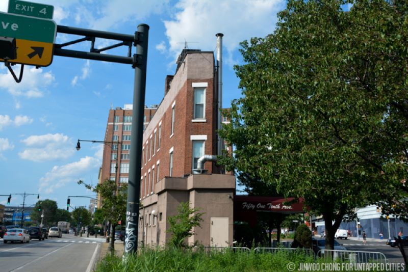
Prior to the construction of the West Side Elevated Highway, the New York Central freight line ran at street level, giving the stretch of Tenth and Eleventh Avenues the nickname Death Avenue. The moniker comes from the consistent and often fatal collisions between trains and people along the busy thoroughfare. The street-level tracks were used to ship commodities such as coal, beef, and dairy products.
Before the trains were elevated, the New York Central Railroad hired men on horseback armed with red flags to ride in front of the trains to signal their arrival. They came to be known as The West Side Cowboys. However, they were unable to prevent many further disasters, with some estimates revealing well over 500 deaths just along Eleventh Avenue over the years. The West Side Improvement Project, developed by Robert Moses, eliminated 105 street-level railroad crossings and ultimately expanded Riverside Park. The first official proposal for an elevated highway along the west side was made by Police Commissioner Richard Edward Enright on January 12, 1924.
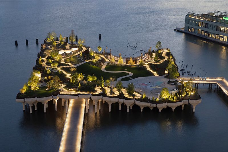
Little Island is built atop the remains of Pier 54 and Pier 55, which once served the glorious Cunard steamship lines. Cunard has a connection with almost all the major ships that came to or departed from New York City, some with unfortunate ends. The RMS Lusitania left from here in 1915, to be sunk by a German torpedo close to its destination. The Titanic was supposed to dock at neighboring Pier 59 but never made it. However, the RMS Carpathia which rescued survivors did dock at Pier 54.
Little Island’s fascinating engineering, led by Arup, enables the park to rise on 280 organically-shaped concrete piloti on top of which sit 132 concrete “tulips.” The piloti mix in with the pilings of the former piers, which were retained as much as possible. The design provides for an elevated vantage point while in the park, as well as offers a variety of different spaces to experience. With 350 species of flowers, trees, and shrubs, the lush park has a lawn space known as “The Glade,” a 687-seat amphitheater, as well as the provision of food and beverage vendors along a central plaza that contains seating.
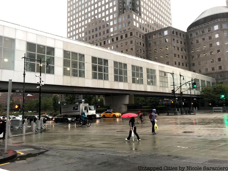
To avoid pedestrian accidents on the busy roadway, a number of pedestrian bridges were erected for safer travel. Skidmore Owings and Merrill designed the Chambers Street Bridge, which connects Stuyvesant High School and the property of the Borough of Manhattan Community College. The $10 million bridge opened in 1992 with the construction of glass elevators to match handicap access requirements. The Liberty Street Bridge sustained significant damage from 9/11, but was repaired and extended just a few months later. to connect to the new Liberty Park. The original Vesey Street Bridge was destroyed in the 9/11 attacks, and a new bridge was constructed in its place in 2003. Following years of complaints about elevator malfunctions and closures due to the construction of One World Trade Center, it was shut down in 2013 and demolished.
Since the Liberty Street and Vesey Street bridges were closed, Battery Park City residents needed a safer way to cross the highway rather immediately. The Rector Street Bridge was installed in August 2002 from pre-fabricated materials, but debates about its demolition were sparked just a decade later. Residents of the community wanted to keep it since it had become a fixture of the neighborhood, but it was torn down and replaced by the West Thames Street Bridge one block south. Also known as the Robert F. Douglass Bridge, the West Thames Street Bridge near the Brooklyn-Battery Tunnel was completed by late 2019 after delays in securing funding and weld defects. The modern bridge cost a whopping $45.1 million.
Next, check out The Top 15 Secrets of Chelsea!

Subscribe to our newsletter
