
Free
Storefront Art Tour with Pratt Institute + The Village West
Discover how vacant storefronts are being transformed with works of art!
Discover how vacant storefronts are being transformed with works of art!
Untapped New York's founder and author of Secret Brooklyn, Michelle Young, shares her favorite things to do!
Discover how the criminal justice system has impacted music history throughout the 20th century!


Located along the border between Brooklyn and Queens is Ridgewood. Like neighboring Bushwick, Ridgewood’s land was initially the home of the Lenape Native American Mespachtes tribe, before becoming part of Newton, one of the three initial towns formed in Queens, and being settled by the British. For most of the 19th century, Ridgewood remained a largely rural farming area, with residents growing crops for sale in Brooklyn and Manhattan markets. For the most part, development to the area during this time period consisted of picnicking locations, beer gardens, racetracks, and amusement areas for Bushwick residents. Industrialization began to pick up speed following the extension of the elevated Myrtle Avenue subway line to Ridgewood in 1889, the creation of an electric trolley line in 1894, and the completion of the Queensboro Bridge in 1909.
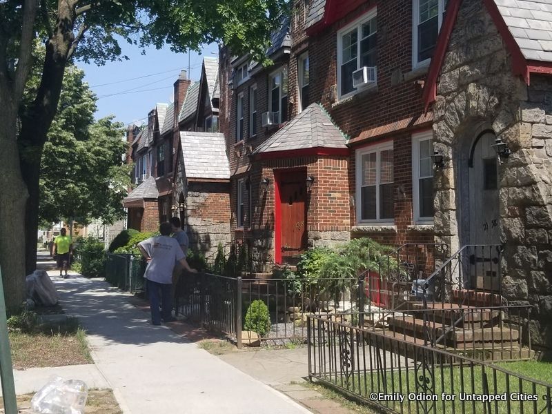
From 1905 to 1915, much of the neighborhood’s housing stock was constructed — mainly occupied by German and Eastern European immigrants. The neighborhood can be visually distinguished for its brick exposed construction characteristic of the early 20th-century row houses built in the area. More than 5,000 buildings in Ridgewood were designed by Louis Berger & Co. during the early 20th century, with the neighborhood’s residential sectors remaining largely untouched ever since. Today, visitors to the neighborhood can stroll through one of its ten historic districts, visit the St. Matthias Catholic Church where scenes from The Irishman were shot, or explore the Ridgewood Reservoir’s lush East Causeway. With a contentious past with Brooklyn and a memorial to fallen World War I soldiers, Ridgewood has many fascinating secrets.
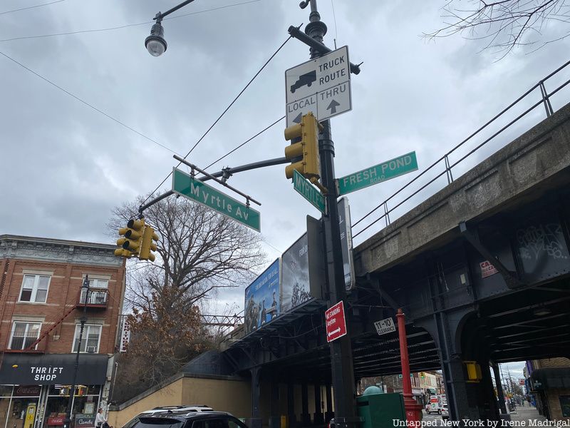
In Ridgewood today, Myrtle Avenue, Metropolitan Avenue, and Fresh Pond Road remain the neighborhood’s oldest streets, first used by farmers to take goods to the market. What is now Fresh Pond Road began as an old trail for Native Americans living in present-day Maspeth, which derived its name from the Mespeathes tribe. Members of the Mespeathes tribe would use the road to travel from Brooklyn to Jamaica Bay where they fished and clammed before returning home to use collected seashells to make wampum, a form of native currency. Upon the arrival of colonists to Queens, the trail came to be known as Kill’s Path on account of it being a site for battles among Native American tribes.
In the 1800s, the trail, having since been incorporated into the town of Newton, was renamed Fresh Pond Road to reflect two small ponds that used to occupy an area east of the roadway and to the north of the Mount Olivet Crescent but were drained and filled in the 1900s. Originally running from Jamaica Avenue in Cypress Hill to 69th Avenue in Ridgewood, Fresh Pond Road’s current route was shortened during the 20th century to run from Flushing Avenue in Maspeth to Myrtle Avenue. The old portion of Fresh Pond Road from 69th Avenue to Jamaica Avenue was transformed into Cypress Hills Street.
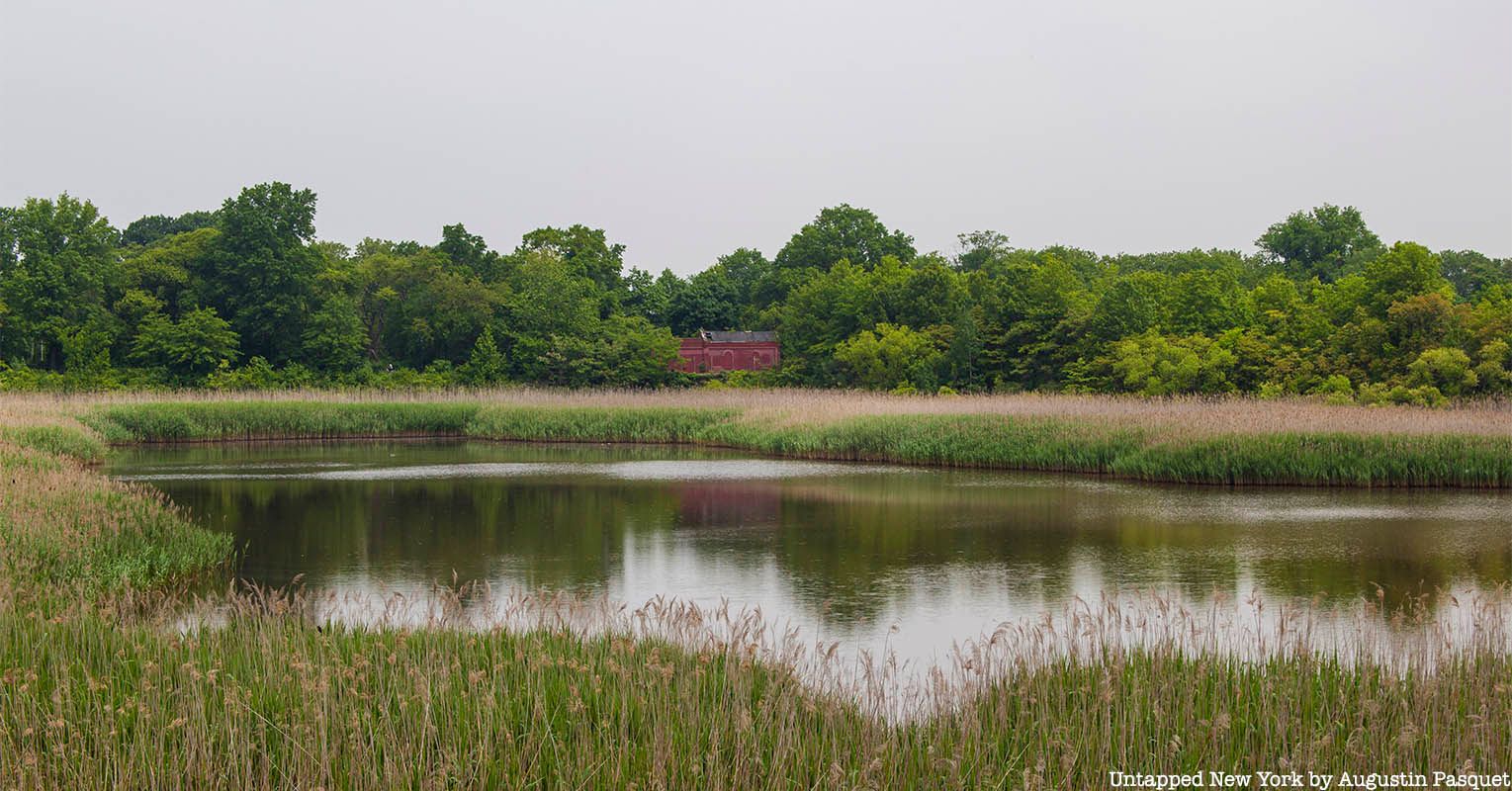
In the southeastern corner of the Ridgewood area is the Ridgewood Reservoir. Built from 1856 to 1858, the 50-acre Ridgewood Reservoir was created to aid in fixing the city of Brooklyn’s rapidly depleting water supply. At the time, Brooklyn lacked a stable water source, with the Croton River already providing resources to the City of New York. The only adequate solution came to be tapping into small streams on Long Island to conduct their water into an elevated reservoir for usage throughout Brooklyn. By 1900, Brooklyn obtained over 45 million gallons of water per day from the Ridgewood Reservoir and other surrounding sites. With the water provided by the Ridgewood Reservoir, the surrounding area’s population began rapidly expanding.
After its decommission in 1990, the Ridgewood Reservoir lay neglected by the city. Nature eventually took over, turning the area in the outer basins into a lush freshwater wetland that attracted various flora and fauna including threatened and endangered species such as the short-eared owl and pied-billed grebe. Surrounding the reservoir’s second basin on the right and left sides are the East and West Causeways, with the East Causeway having been restored by the non-profit organization NYC H2O in June 2021. Once covered in debris and overgrowth, the East Causeway now serves as an important recreational and educational space for New Yorkers to learn more about the city’s natural resources.
Over the years, multiple possibilities for the origins of the neighborhood’s name have arisen. One of the most popular theories asserts that the name was derived from the nearby Ridgewood Reservoir in Highland Park, which received its water from a chain of lakes and creeks near the towns of Hempstead and Jamaica. Originally, an old South Side Railroad station named Ridgewood sat on the eastern extremity of this chain, but eventually, it gave up its bid for possession over the Ridgewood name in 1891, with the local residents petitioning for the postal office to be changed to Wantagh. Others speculate that Ridgewood’s name comes from the character of the territory, which was originally thickly wooded. In early English records, the area was often referred to as “the Ridge” given its location as the backbone of Long Island. In addition, the name could also have come from Ridge Road, which in early deeds was used to designate Wyckoff Avenue.
Ridgewood’s name would first be applied by the Kings County government in reference to the area within Brooklyn along the Kings and Queens County border. During the early 20th century, the area came to be known by different names such as Germania Heights, St. James Park, Ridgewood Heights, and Wyckoff Heights, but only Ridgewood remained popular past the 1910s.
Since as early as 1661, the border between the boroughs of Brooklyn and Queens has been disputed, particularly among residents living in Bushwick, Brooklyn, and Ridgewood, Queens. During the colonial period, these disputes reflected the deeper conflict between Bushwick’s original Dutch settlers and Newton’s English inhabitants. To settle the debate, a bill was passed in 1786 to commission an official line between the townships. A year later, this border was measured from the Arbitration Rock, which also marked the dividing line between Queens County and Kings County. However, following the incorporation of Newton and Bushwick into the City of New York in 1898, Arbitration Rock began to lose its significance.
Eight years later in 1925, the Brooklyn-Queens border was redrawn to alleviate issues that arose as a result of the former boundary, which as a result of having been entirely straight often went through individuals’ homes — subjecting owners to double the taxes. As a result, the addresses of 2,543 persons were reassigned from Queens to Brooklyn and 135 from Brooklyn to Queens. Today, modern addresses along the border can be distinguished by the presence or absence of a hyphen in the house number, with Queens using a hyphen between the closest cross-street and the actual address. In Ridgewood, buildings on streets west of Forest Avenue and the Bay Ridge Branch follow the Queen’s numbering system while buildings on avenues running parallel to the country line bounded by Metropolitan Avenue do not.
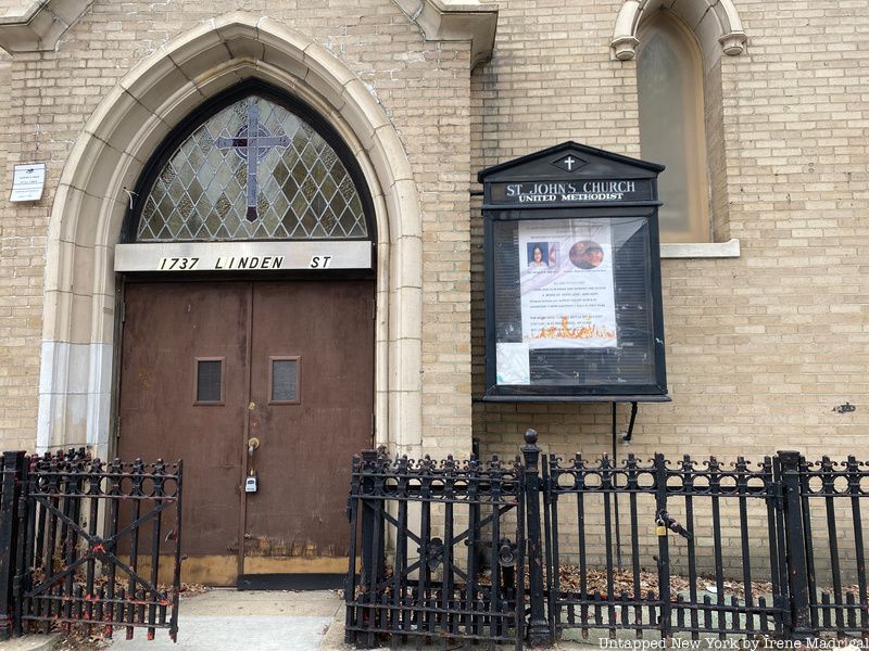
In 1983, ten national historic districts were established throughout Ridgewood and listed on the National Register of Historic Places. Examples of these districts include Cornelia-Putnam, Fresh Pond Traffic, Seneca Avenue, Summerfield Street Row, and Cypress Avenue West —which includes St. John’s United Methodist Church — among others. One of the neighborhood’s most notable historic districts is Central Ridgewood, which features 990 buildings constructed between 1895 and 1927. Most of these structures consist of two-story brick row house dwellings with one apartment per floor. Characteristic features of the buildings include rounded bay front facades and shades of speckled brick for the exterior derived from a mix of the Renaissance Revival and Romanesque Revival styles.
The Central Ridgewood Historic District also occupies land that was once divided between several of New York City’s most prominent families such as the Wykoffs, Duryeas, Woodards, and Debevoise. As a result, the district holds the remains of these families’ homes, one of these being the John C. Debevoise House, which in 1974 was demolished and turned into a senior center. Other former historical sites in the district include the Queen’s Labor Lyceum, a social club for local workers which closed in 1975. In addition, Ridgewood also possesses four landmark districts. One such district is the Stockholm Street Historic District, which was designated in 2000 and contains the only remaining brick street in Ridgewood.
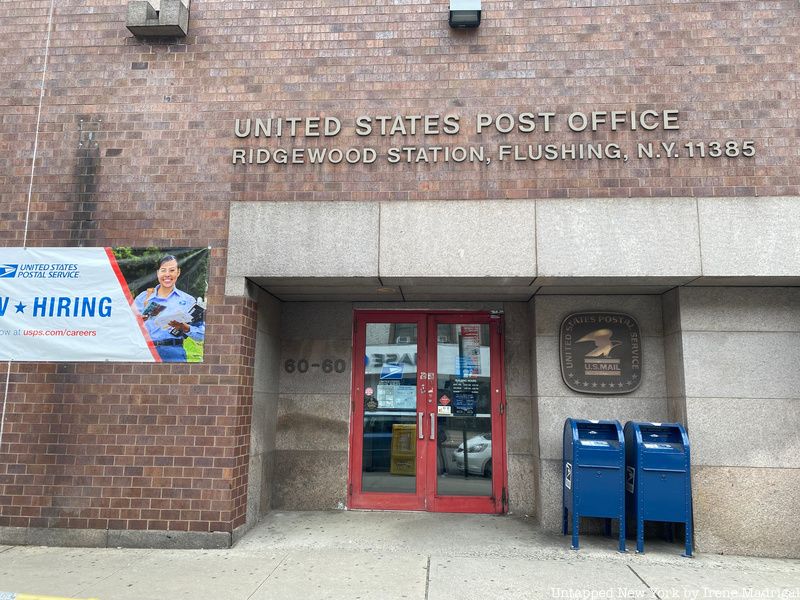
Beginning in 1898 with the consolidation of the City of New York, both Ridgewood and neighboring Glendale had their postal mail routed through Brooklyn’s post office in Williamsburg, rather than through Queen’s main office in Flushing, as a result of the closer proximity. The neighborhood’s political connections to Brooklyn continued with the assignment of zip codes in 1963, with Ridgewood, Bushwick, and Wyckoff Heights being made to share 11227. In turn, Ridgewood came to possess a Brooklyn mailing address despite being physically located in Queens.
While the Brooklyn zip code was accepted at first, this began to change following the 1977 New York City blackout as newspapers such as UPI and Associated Press presented photos of the Bushwick neighborhood overtaken with riots and looting. In response, residents of Ridgewood and Glendale began to express interest in disassociating themselves from the negative legacy of Bushwick. As complaints mounted, it was determined that the neighborhood’s zip code could be changed if U.S. Representative Geraldine Ferraro could secure support from 70% of residents. After putting the issue to vote, 93% of the collected ballots remained in favor of the change. On January 13, 1980, Ridgewood officially adopted the Queen’s zip code of 11385.
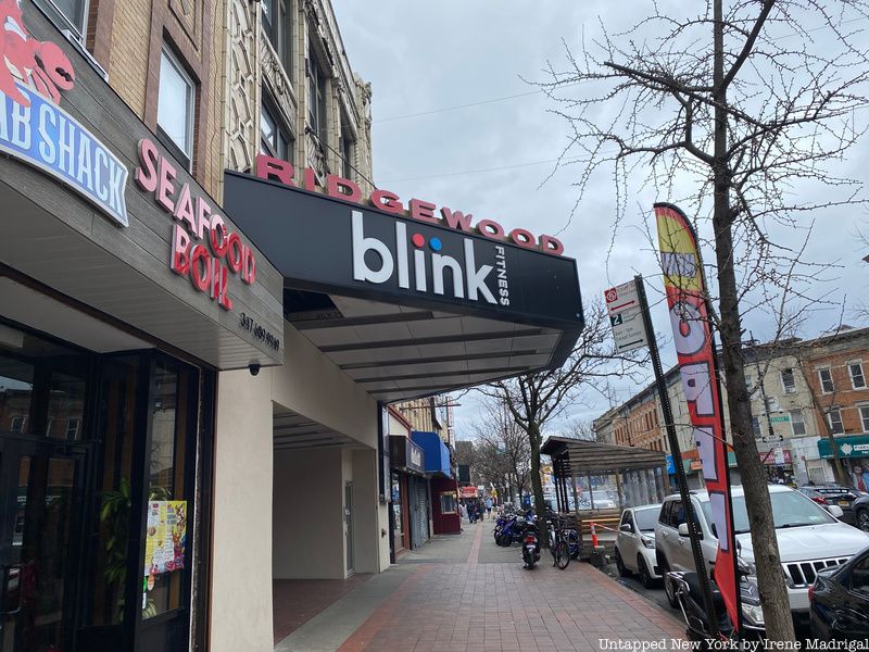
Constructed in 1916 by the Ridgewood Operating Company — established by Levy Brothers Real Estate — the Ridgewood Theater was located on Myrtle Avenue in Ridgewood’s rapidly developing commercial area. Its design, curated by architect Thomas Lamb, draws inspiration from classical and geometric elements such as pilasters and heavily encrusted shields made from glazed terra cotta. In addition, the building’s white facade distinguished it from the surrounding area, modeled after Strand’s theater. Built during the early stages of the development of movies, Ridgewood’s theater helped to bring the new art form to the local community for the first time. For more than 90 years, the 1950 seat Ridgewood Theater showcased movies on a continual basis, spanning the era of “talkies” all the way to the modern motion pictures of the 21st century.
The Ridgewood Theater joined William Fox’s movie chain in 1923, which at the time was the dominant force in the film industry. Following lawsuits from competitors and the economic problems of the Great Depression, Fox was forced to declare bankruptcy in 1936 and three years later the theater was sold to the Nately Operating Company. During the 1980s, the Ridgewood Theater became part of the United Artists chain and was converted into a multiplex theater with five screens. In March 2008, the Ridgewood Theater was shut down, ending its reign as one of Brooklyn’s longest-running theaters. As a result of the building’s landmark status, which it earned in 2010, the theater’s facade has remained the same. On the inside, the building was gutted and replaced with a Blink Fitness Center.
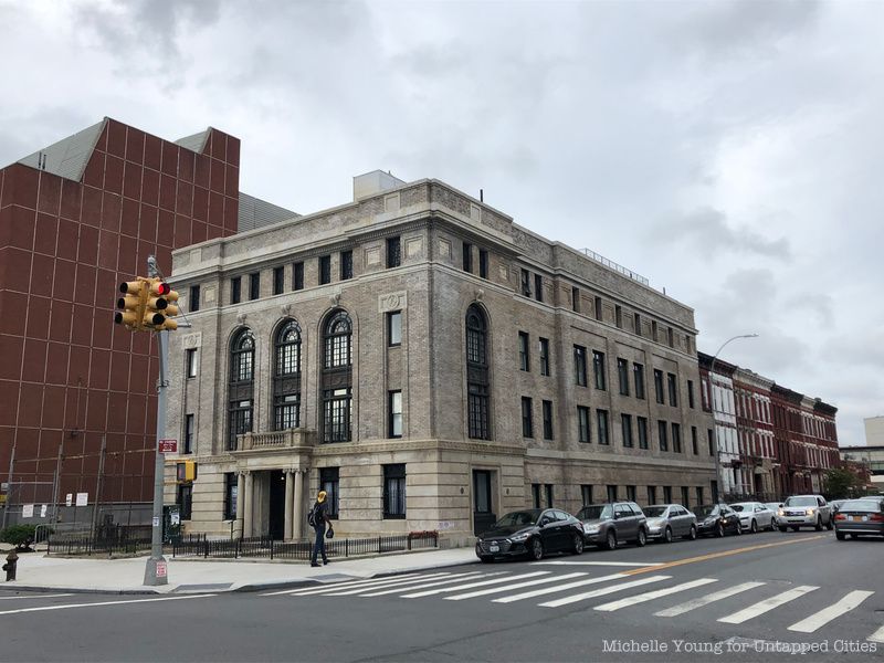
Located at 1045 Bushwick Avenue is Ridgewood Lodge No. 710, known more commonly as the Ridgewood Masonic Temple. Constructed between 1919-1920 by the Koch & Wagner architecture firm — also known for their work on the East Brooklyn Savings Bank that today serves as a Chase — the Ridgewood Masonic Temple is the only neoclassical Beaux-Arts building along Bushwick Avenue. It follows in the tradition of Masonic lodges constructed as monumental buildings in prominent places with an ornamental front facade being ornamental preserving the secretive nature of Masonic rituals. Though the Ridgewood Masonic Temple is located in Bushwick today, as its name suggests, it was originally built in the Ridgewood neighborhood. At the time of its construction, its location at 1054 Bushwick Avenue was within Ridgewood, but this changed during the Brooklyn-Queens border shift in 1925.
The Ridgewood Masonic Temple was formerly occupied by the Free and Accepted Masons, with #710 encompassing Ridgewood Lodge #710, Cypress Hills Lodge #1064, and Star of Hope Lodge #430. Ridgewood Lodge would host its first meeting at 943 Gates Avenue on September 28, 1870, with RW Henry W. Turner serving as the grandmaster. During the 1970s, the Ridgewood Lodge disbanded to the Astoria Lodge in College Point in the face of declining membership. The temple was then appropriated as a venue for concerts and orgy-filled parties, many of which were thrown by the famed indie music promoter Todd Patrick. In the early 2010s, the building was slated to be torn down to create 28 rental apartment units, however, before this could occur, the building was given landmark status in July 2014.
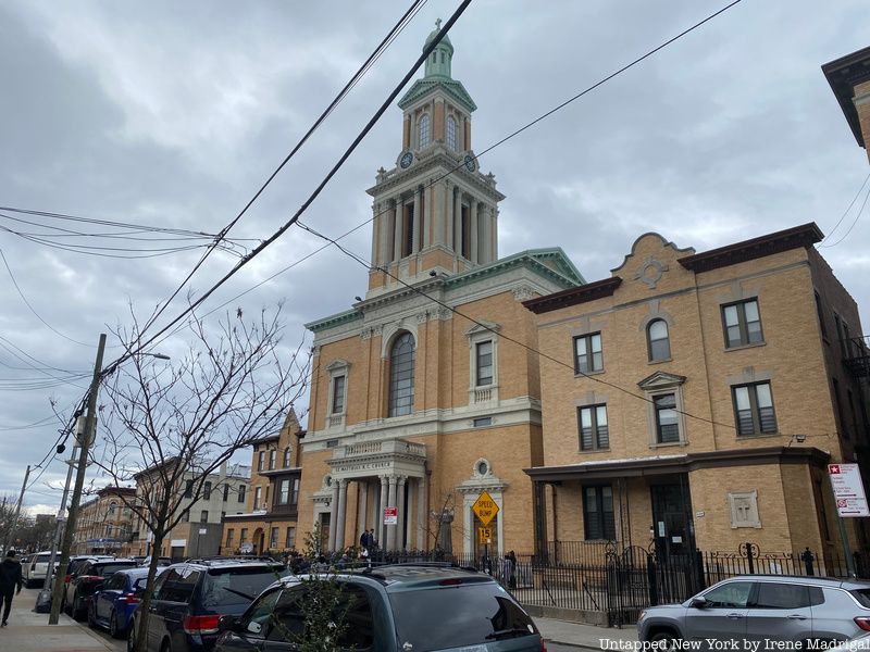
Located on Catalpa Avenue is St. Matthias Catholic Church, one of Ridgewood’s oldest parishes. On May 2, 1908, Bishop Charles E. McDonnell of the Diocese of Brooklyn desired to create a new Roman Catholic parish for practitioners in Evergreen and Ridgewood. To do so, Reverend Nicholas M. Wagner was appointed the pastor of St. Matthias R.C. Church, which held its first Holy Mass on August 30 at a nearby restaurant near what was once Ridgewood Park and is now the area surrounding Myrtle and Seneca Avenues. One week later, Father Wagner secured 20 lots on Elm Avenue, now Catalpa, from the Meyerose Estate. Ground was broken on the new property on March 19 of the following year creating a new church and the School of St. Matthias.
Following the end of World War I, construction began on a new church building, with the first phase, a basement church, being completed in August 1919. After raising the necessary funding, the cornerstone of the current St. Matthias Church was completed on October 5, 1924. In 2012, the Church was listed on the National Register of Historic Places and remains an important part of the Ridgewood South Historic District. Most recently, St. Matthias Catholic Church was also used in Martin Scorcese’s 2019 Netflix film, The Irishman, with its inside being featured during the baptismal scene. In addition, the area around the church was used for exterior shots of the Philadelphia-based restaurant Villa di Roma, the Friendly Lounge, and for the scene in which Frank beats up a grocery store owner.
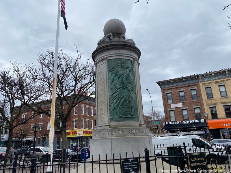
At the intersection of Myrtle and Cypress Avenues is the Ridgewood War Memorial, which commemorates the 110 servicemen from Ridgewood who died during World War I. The memorial was gifted by the American Gold Star Mothers, an organization of mothers who lost sons and daughters in service of the United States Armed Forces. It is located within the Myrtle Avenue Clemens Triangle and was dedicated on Memorial Day in 1923.
The Ridgewood War Memorial features bronze bas-reliefs created by sculptor Anton Schaaf, which represent the Army, Navy, and Air Force. The Army bas-relief is of a soldier and woman holding a torch, the Navy bas-relief features a sailor and Neptune, and the Air Force bas-relief depicts an aviator and an allegorical female figure. these bas-reliefs have been placed onto an 11-foot high cylinder surmounted by a low-relief globe designed by Helmle and Corbett architects. Besides the Ridgewood War Memorial, Schaaf also worked with Helmle and Corbett on the Glendale War Memorial in Queens. In 2003, the memorial was restored through a city capital contract.
Next, check out 18 Must-Visit Spots In Ridgewood, Queens: An Untapped Cities Guide!

Subscribe to our free newsletters
Free Newsletters
Get the best stories and things to do sent straight to your inbox.