Did you know that the Staten Island Railway can trace its roots back to an investment by Gilded Age tycoon Cornelius Vanderbilt? The railway has been operational since it was owned by the Baltimore and Ohio Railroad in the early 1880s. The line starts up at the rail-ferry terminal of St. George and winds through the center of the island down to Tottenville near Raritan Bay. The single rail line functions as the only rapid transit system on the island and releases some of the pressure put on buses to connect travelers with the city’s other boroughs.
The Staten Island Railway is a subsidiary of the MTA and operates on a similar schedule with the same fare rate of $2.75. Passengers traveling in between stops on the island from Tottenville up to Stapleton can ride the train for free, but those who want access to and from St. George will need to pay the fare. Trains run 24 hours a day, seven days a week at intervals from 10 to 30 minutes depending on the time of day.
The Staten Island Railway saw a decent amount of profit in its early years and began with an investment from Gilded Age tycoon Cornelius Vanderbilt, who controlled a number of major railroad companies in the northeast. The company started to decline in the 1870s and eventually had to be foreclosed due to competition with a booming ferry company that sprouted up in Lower Manhattan. Investor George Law, whom the St. George neighborhood was named after, would go on to purchase the land and look after the development of a rail-ferry terminal that would greatly boost service to the company. The construction of the St. George Terminal coincided with what ultimately was the birth of the Staten Island Railway as we know it today.
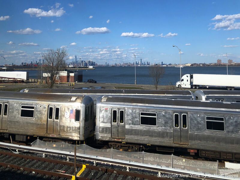
When the railroad was purchased by the MTA in 1971, six new R44 units were put into service to replace the outdated ME-1 units. The R44 is the only model used by the Staten Island Railway to this day with 63 individual cars, but there are plans to replace these with the brand new R211 model. And now, onto the starting point at St. George!
St. George
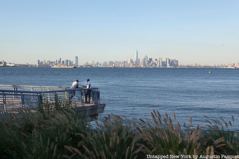
View of Lower Manhattan from St. George
The northernmost terminal on the Staten Island Railway is part of the largest transportation hub for commuters traveling in and out of the borough. More than 70,000 people use the St. George rail-ferry terminal each day to travel off the island, many of whom utilize the Staten Island Ferry to get Lower Manhattan in just 20 minutes. The terminal opened to the public in 1886 and was later followed by the construction of a railroad station in 1887. It remains one of the few rail-boat connections left in the entire United States.
The land was previously inhabited by the Lenape Native American tribe for centuries before it was settled by the Dutch upon their arrival in the mid-17th century. Much of the neighborhood was developed by former U.S. Vice President Daniel D. Tompkins in the early 1800s until a financier named George Law was hired in 1880 to secure a contract for the waterfront property. Erastus Wiman, the businessman who hired Law to acquire the land, honored the financier by changing the name of the neighborhood from New Brighton to St. George.
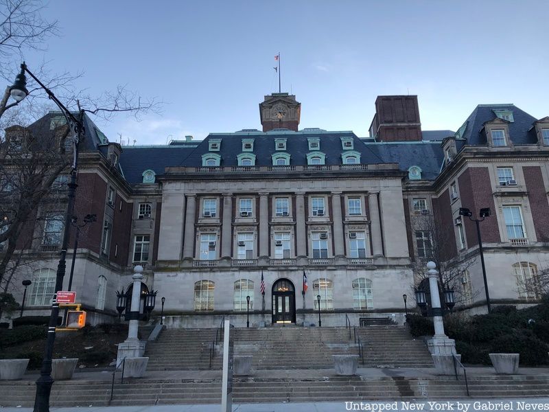
St. George features a variety of historical buildings and landmarks in what continues to be the primary municipal center of Staten Island. Beaux-Arts buildings such as the Staten Island Borough Hall and the Richmond County Courthouse are located just across the street from the ferry terminal. These two buildings were designed by Carrère & Hastings, the same architectural firm responsible for the creation of the Frick House, the main branch of the New York Public Library, and the Metropolitan Opera House.
Staten Island Borough Hall, just across Richmond Terrace from the ferry terminal
The National Lighthouse Museum, located just a few blocks away from the municipal buildings, once housed the general depot for the United States Lighthouse Service. The location used to store different kinds of equipment for maintaining and building lighthouses along the East Coast. Vaults within the building were filled with items like lamp oil, ship anchors, chains, and lenses. After the need for lighthouses began to diminish in the early 1900s, the facility was eventually granted to the United States Coast Guard in 1939. The depot was abandoned and vandalized for decades after that until the museum eventually opened its doors in 2015.
History is also represented by the houses found in St. George. Plenty of the homes, especially around Curtis High School in the area’s historic district, used to be summer getaway destinations for wealthy Americans in the 19th century. Victorian, shingle-style, Greek-revival, Tudor, and Colonial Revival houses are the architectural styles on display in the neighborhood. There is even an Art Deco-style apartment building where actors Paul Newman and Martin Sheen used to live.
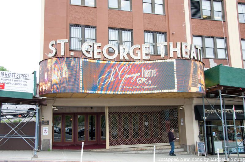
St. George Theater
The St. George Theater and the Richmond County Bank Ballpark are two other neighborhood landmarks. The 2,800 seat theater, located just up the hill on Hyatt Street, has an interior design modeled after some of the finest performing arts centers in the city. Musicians like Chaka Kahn and Lester Flatt, as well as comedians Chris Rock and Jerry Seinfeld, held performances at the St. George Theater.
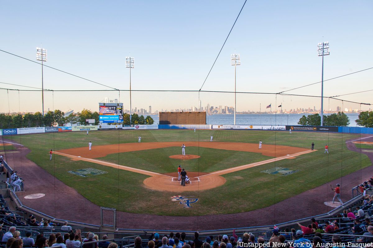
Richmond County Bank Ballpark
The ballpark sits adjacent to the St. George Terminal and was the former home of the Staten Island Yankees until the minor league team was disbanded in 2020. The stadium is currently undergoing a surface renovation so that it can host games for local rugby and soccer teams. As we move on from St. George, let us take a ride along the Staten Island Railway!
Riding the Line – North Shore
View of New York Harbor, Lower Manhattan, and Brooklyn from a train approaching Clifton
The R44 multiple unit pulls out of St. George and makes its way toward its first stop in Tompkinsville. The area was named after former New York State Governor and U.S. Vice President Daniel D. Tompkins, the same man who was responsible for the housing developments in St. George. Before his contributions to the neighborhood, European explorers in the late 18th century would come ashore to replenish their water supplies.
Today, the area features a diverse ethnic population and is home to one of the largest Sri Lankan communities in the U.S. with around 5,000 residents. Housing in the neighborhood is also more urbanized than other residential communities on the island in terms of the number of apartment buildings and housing projects. This is also the only station other than St. George that requires passengers to pay a fare.
The next stop on the line is Stapleton, one of the oldest waterfront communities on Staten Island. American entrepreneur Cornelius Vanderbilt grew up on a farm in the area, which was eventually sold by the family at the start of the 19th century. William Staples and Minthorne Tompkins, the son of Daniel D. Tompkins, purchased the land and began laying out streets for the new neighborhood. The area became increasingly popular due to its commercial importance to the island, attracting a number of breweries, the construction of direct ferry service to Manhattan, and even a pro football team that played in the NFL for almost a decade. However, like many other communities along the bay, Stapleton was drastically affected by the construction of the Verrazzano-Narrows Bridge in 1964, shifting much of the economic development towards the central areas of the island.
The final stop along the northern shore of Staten Island is located in the neighborhood of Clifton. Much of the land was owned by the Vanderbilt family, but it eventually came under control by the Townsend family in the 1840s. The area was rather underdeveloped for the larger part of the 19th century, and it wasn’t until around the turn of the century that a residential community began to develop. The neighborhood gradually developed past the 1960s into a lower-income residential area at the start of the 1970s, which led to the sprouting of gang violence, rises in poverty, and unemployment. The area is known as well for its Liberian population, many of whom were immigrants fleeing the Liberian Civil War that occurred throughout the 1990s. Plenty of notable individuals spent much of their lives in Stapleton, including six of the nine members of the Wu-Tang Clan, Central Park and Prospect Park designer Frederick Law Olmsted (whose house still stands), and author Henry David Thoreau.
Riding the Line – Eastern Shore
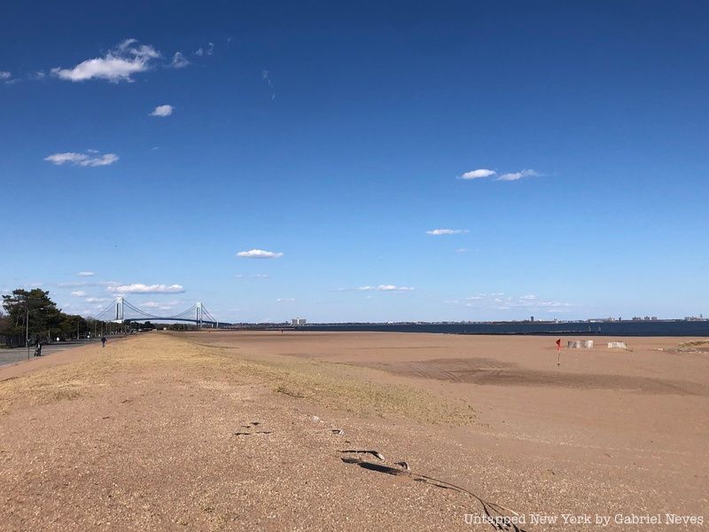
View of the Verrazano-Narrows Bridge from Midland Beach.
The train then pulls out of the station, passes under the Staten Island Expressway, and stops at Grasmere, the first station located along the eastern shore of the borough. The distance between the Clifton and Grasmere stations is the furthest between two stops on the entire line, which has led to the discussion of whether or not a station should be built to close that distance in the Rosebank section (which has some great historic highlights, including the Alice Austen House, and the Garibaldi-Meucci Museum). Grasmere in itself is a quiet, suburban area that was named after a village in England with similar lakes and other geographical features. Grasmere Lake and Cameron Lake are privately owned and are located between the Staten Island Railway and Hylan Boulevard.
Old Town is the next stop on the Staten Island Railway as we continue our ride further down the shore. The neighborhood was the first permanent settlement on Staten Island as part of the New Netherland colony in 1661. Dutch and French settlers, led by lead explorer Pierre Billiou, claimed the land and eventually named it “Oude Dorp,” or “Old Village,” so that it wouldn’t be mistaken for the name of a settlement that developed just south some years later. Old Town was home to the New York Tattoo Museum, which was open from 2010 to 2017. It was located on the second floor of a building on Old Town Road and had three small exhibits, which taught visitors the history of tattoo art itself rather than just the machinery and technology used to make them.
Dongan Hills, unlike many of the other neighborhoods along the Staten Island Railway, saw great benefit from the construction of the Verrazzano Bridge in 1964. The neighborhood consists primarily of small, one-family homes, but it also features some apartment complexes and has the southernmost public housing project on Staten Island. The area was named after the former Irish-born governor of New York, Thomas Dongan, who held power in 1682. Most of the residents in the neighborhood are Italian-American and were previously Brooklyn residents who moved across the bay. The former home of Pierre Billiou, the explorer who first acquired the Old Town section of the island, is located in Dongan Hills.
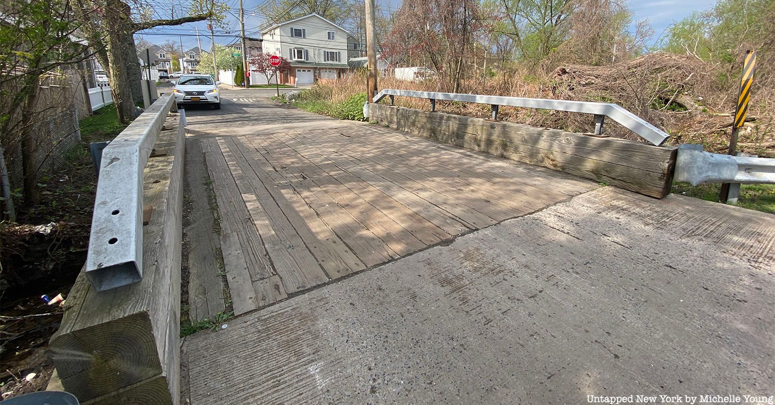
The next two stops on the Staten Island Railway are at Jefferson Avenue and Grant City, which fall in the neighborhood of Midland Beach. The area is a popular destination for beachgoers on Staten Island, and its seaside recreational facilities are what draw the most attention. The Franklin D. Roosevelt Boardwalk stretches down the east shore from the neighborhood of Arrochar and features a number of memorials honoring Staten Island residents who served in both World Wars, the Korean War, and the Vietnam War. It had been a resort location since the 1890s, when the Staten Island Railway was first brought to the area. Upland from Midland Beach you can find one of the last wooden bridges on Staten Island.
One of the last wooden bridges on Staten Island
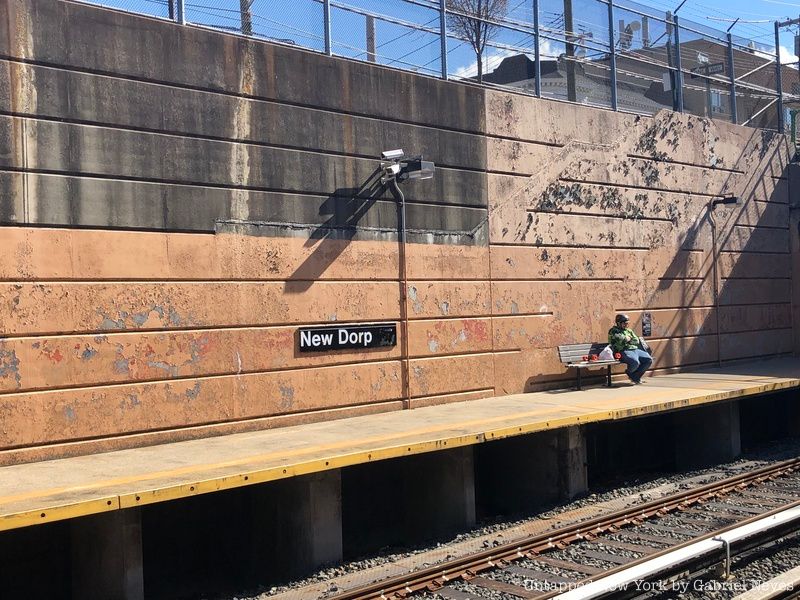
The next stop past Midland Beach is New Dorp, which is currently one of the primary commercial centers in the borough. Along with Old Town, the neighborhood was one of the first established communities on Staten Island. The Vanderbilt family had a large stake in the community during the 19th century and played an important role in the community’s suburban housing development. By the 1960s, the shopping centers and department stores on Hylan Boulevard, New Dorp Lane, and Hylan Plaza became well-frequented locations for many Staten Island residents. New Dorp Lane to this day hosts community events, including the New Dorp Food Crawl, the Family Fun Walks, and the New Dorp Lane Car Show. One of the last pre-World War II theaters on Staten Island, the Lane Theater, is also located in New Dorp. It was constructed in 1938 and is one of the few Art Moderne-style theaters in the entire city.
Oakwood Heights just south of New Dorp was originally a summer resort community until the construction of the Staten Island Tunnel was proposed to link the Staten Island Railway with the New York City Subway. Because the tunnel was set to give Staten Island residents direct access to the rest of the city, heavy suburbanization started to take place in the neighborhood. Frederick Douglass Memorial Park is one of the many cemeteries in Oakwood Heights, but was also a specifically designated burial ground for African Americans. A traffic circle called Amundsen Circle honors the explorer Roald Amundsen, who was representative of the large Norwegian population in the neighborhood during the 1930s.
As the train gets closer to its southern terminal, the next stop on the Staten Island Railway is Bay Terrace. The neighborhood was originally named Whitlock after the Whitlock Realty Company, which was responsible for the development of the land in the area. There was previously a high number of Jewish residents in Bay Terrace during the 1970s, many of whom moved in from the boroughs of Queens and Brooklyn. In addition to the ever-present Italian-American population, there has also been a large increase in the number of Russian-American residents over the last several years. Ron Thal, a former guitar player for the rock band Guns N’ Roses, lived in Bay Terrace until his mid-20s.
Riding the Line – South Shore
Passenger waiting on the northbound platform at New Dorp Station
Now entering the section of the borough recognized as the South Shore, Great Kills is the next station. The neighborhood’s name originated from the number of streams and creeks found on the land. It used to be a fishing community in the 19th century with ships docking on its harbors to sell and trade oysters, clams, and crabs. Great Kills Park is a popular section of the neighborhood and is an official part of the National Park Service’s Gateway National Recreation Area. The beaches and wetlands in the park are critical in protecting the Great Kills neighborhood from flooding that occurs especially during heavy rains and storm surges. The natural harbor offers visitors a place to boat, fish, and even eat at some of the oceanside restaurants.
Eltingville is the next stop on the line and is recognized as the original South Side of Staten Island. Many of the homes in the neighborhood were built by Scandinavian families in the early 1900s, some dating even as far back as the 1700s. Because the surnames between families were so common, businesses would often include surnames in their title order to differentiate between different family groups. There has been a struggle to preserve these homes, however, as they continue to be demolished without any sort of recognition for the contribution they made toward the growth of the community in Eltingville.
Annadale is the next station along the line and is located in the neighborhood of Woodrow. The area is historically known for having built the first-ever Methodist church in New York City. The Woodrow Methodist Church was constructed in 1787 after a congregation had been established under the guidance of British preacher Francis Asbury. The neighborhood is one of the more modern residential areas on Staten Island and saw large renovation efforts during the 1980s.
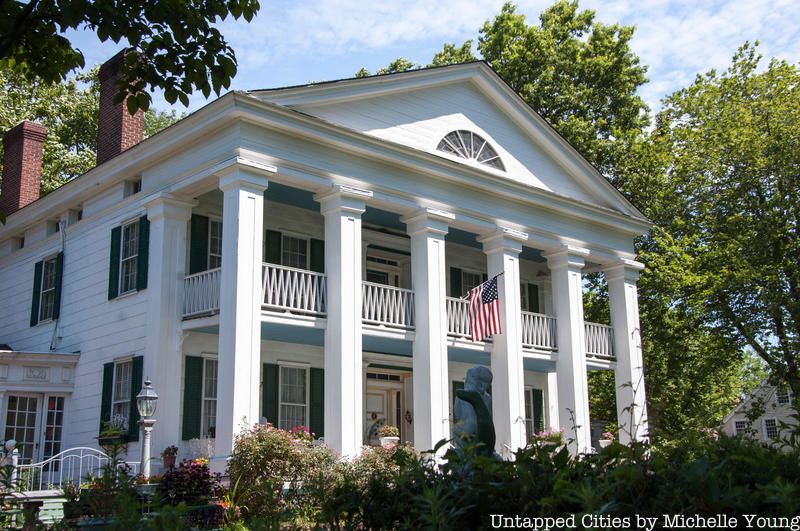
Next is Prince’s Bay, which at one point was a highly regarded fishing village that sold its seafood to many restaurants in New York City and even across the Atlantic in London. The name has often been mispronounced as “Princess Bay,” and even the nearby USPS Post Office left out the apostrophe in its official title. There used to be a large factory owned by the S.S. White Dental Manufacturing Company in Prince’s Bay that was the largest employer in the borough during the 1970s. However, once the factory was closed down and turned into a shopping center, the new business could not quite compete with the pre-existing Staten Island Mall in New Springville. Some of the oldest homes in New York City are also located in Prince’s Bay, including the Seguine Mansion and the Abraham Manee House, which were both constructed sometime before the 1670s.
Seguine Mansion
Finally, the penultimate neighborhood on the Staten Island Railway is Pleasant Plains, which was given its name by the original owners of the railway company back in its early years. Land that was once the largest farm in New York State was bought by Reverend Christopher Drumgoole in 1871 to be converted into green space and an orphanage building. Drumgoole had already established an organization for homeless boys in Manhattan at the time, but the property he funded would go on to help even more children until it went into disrepair after years of service. The land is now a park that features a wide array of fauna and flora located along the shore. Now, pulling into the last stops at Tottenville!
Tottenville
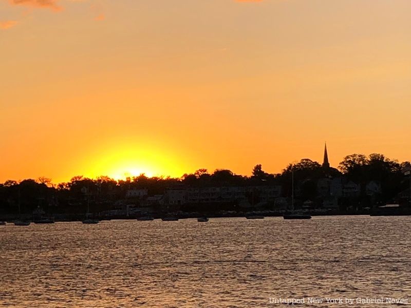
Sunset view of Raritan Bay from Tottenville
The Richmond Valley, Arthur Kill, and Tottenville stops on the Staten Island Railway leave passengers at the southernmost settlement not just in New York City, but in all of New York State. Like most of Staten Island, the Raritan band of the Lenape tribe controlled most of the territory in Tottenville. One of the first settlers to arrive there was Royal Navy Captain Christopher Billop, who named the area “Bentley Manor” after his ship. The name was changed to Tottenville in the mid-19th century to honor John Totten and the Totten family, who lived on the land for several years.
The residences in Tottenville are unique when compared to the rest of the housing developments on the South Shore. The Victorian-style architecture used for many of the homes resembles the style in the St. George area. Most of the buildings were preserved to honor the area’s significance during the American Revolutionary War, avoiding any restructuring or modernization to accompany the progress of nearby residential areas.
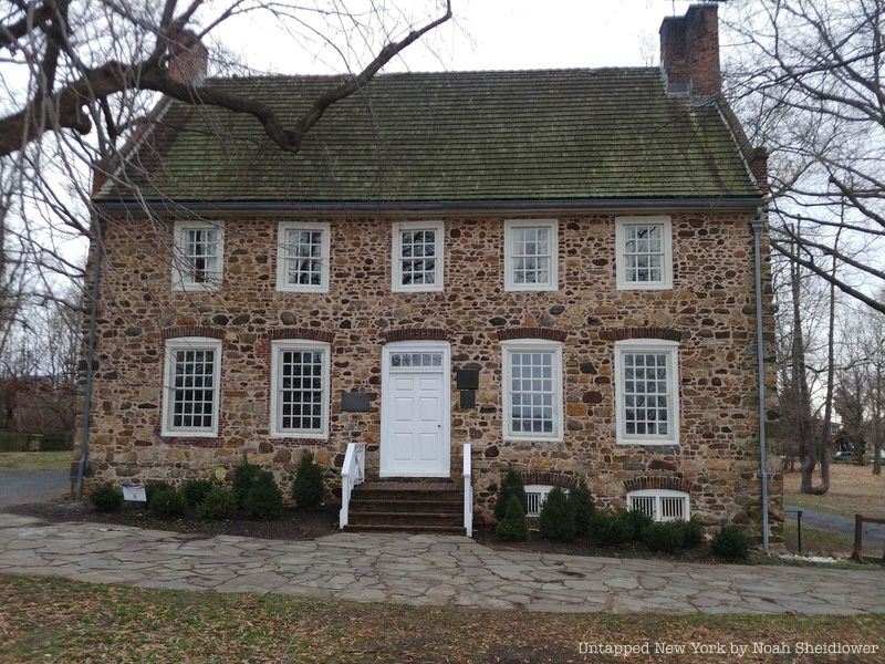
Conference House, site of crucial Revolutionary War meetings, located in Conference House Park
Conference House Park, for instance, was the site of crucial peace negotiations that took place between the British and Continental armies during the war. The stone manor, built-in 1680, was named the Conference House because of these talks and eventually became the central attraction for visitors to Conference House Park. The former Lenape campsite and burial ground feature small beaches, bike and walking paths, and a visitors’ center.
Tottenville used to be a prominent shipbuilding and oyster harvesting town during the start of the 1900s. For these reasons, the area was quite industrial and had factories lined up all along the western shore of the town. When shipbuilding companies began to transition from wood to steel construction, business started to die down in Tottenville. The oyster business was also shut down because of the growing pollution in Raritan Bay and in Arthur Kill.