
Things to Do
🛶 Canoe on the Gowanus Canal + More Ways to Summer in Brooklyn
Untapped New York's founder and author of Secret Brooklyn, Michelle Young, shares her favorite things to do!
Untapped New York's founder and author of Secret Brooklyn, Michelle Young, shares her favorite things to do!
Discover how the criminal justice system has impacted music history throughout the 20th century!

Join an exclusive behind-the-scenes tour with owner Joe Cooke!


Driving, cycling, and walking are the only ways to get across the Brooklyn Bridge today, but for over half a century, trolley lines and elevated rail cars ran across the bridge. In the early 1900s, as traffic on these elevated rails reached its peak, plans were proposed to help ease congestion by connecting all rail lines from the East River crossings to the subway system. Though never completed, the remnants of this partially built rail route still exist within the bowels of the subway.
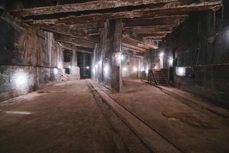
The path that would have connected the Brooklyn Bridge to the subway was called the Centre Street Loop, or Brooklyn Loop Line. Plans for this four-track route were approved by the City in 1907. Its intention was to connect all rail lines traveling over the East River crossings of the Brooklyn Bridge, Manhattan Bridge, and Williamsburg Bridge. The Brooklyn Bridge was to be connected to the loop via two tracks that ran through tunnels from the anchorages of the bridge on the Brooklyn side to the massive subway station below the Municipal Building on the Manhattan side, which was under construction starting in 1909.
The station below the Municipal Building was the Chambers Street subway station. This station was to be the central hub of the new loop route. You see the image of the Brooklyn Bridge in the decorative mosaic tiles at the Chambers Street platforms for this reason. Uncertainty over the building’s design caused delays in the construction of the loop. There was also confusion as to who would run it, as the City had only contracted the Brooklyn Rapid Transit Company (BRT) to build the infrastructure.
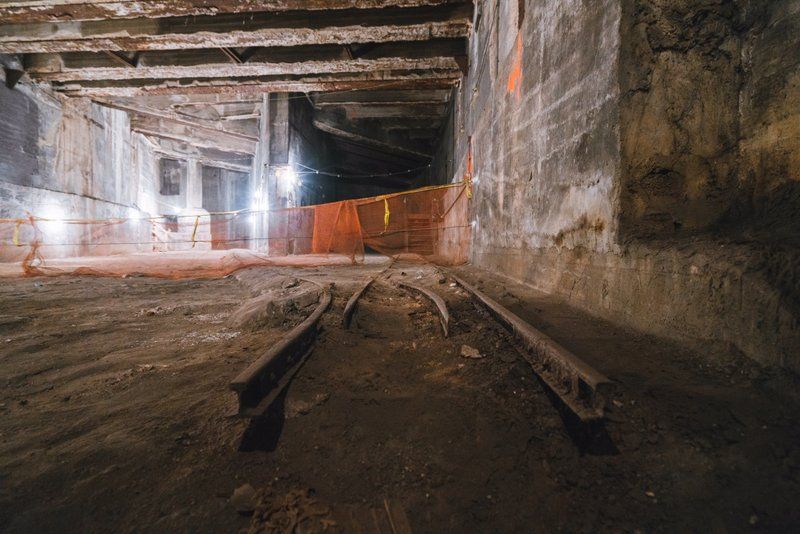
While the tunnels were dug and the ramps partially built, the tracks were never completed. By 1910, while the Manhattan and Williamsburg Bridge sections were already up and running, the section of the loop beneath the Municipal building was still under construction.
Part of the new subway loop went into operation in 1908 when Mayor McClellan started the first train to go over the Williamsburg Bridge. Service to the Chambers Street station wouldn’t fully open until 1913. The partial route of the Centre Street Loop that was built is now known as the Nassau Street Line.
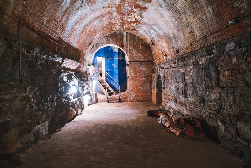
Tracks to the Brooklyn Bridge would have been located at the southern end of the Chambers Street station. They were to curve eastward and climb to connecting ramps onto the bridge according to Mark S. Feinman. The steep grade needed to reach the bridge was part of the reason the approach was abandoned. While portions of the ramps may still exist at Chambers Street, they are inaccessible and can not be seen from any public areas or trains. The images you see here were taken multiple years ago. The subway provision was accessed through vaults that once served as champagne cellars. This cavernous space connects to the IRT Brooklyn Bridge station but is off-limits to the public.
You can uncover more secrets of the Brooklyn Subway system and peek into some abandoned stations on our upcoming Underground Brooklyn Subway Tour and hear more about the champagne vaults and Cold War shelter at the Brooklyn Bridge on our walking tour of the Secrets of the Brooklyn Bridge and DUMBO!
Next, check out 10 Secrets of the Brooklyn Subway

Subscribe to our free newsletters
Free Newsletters
Get the best stories and things to do sent straight to your inbox.
