Last-Minute NYC Holiday Gift Guide 🎁
We’ve created a holiday gift guide with presents for the intrepid New Yorker that should arrive just in time—
We’ve created a holiday gift guide with presents for the intrepid New Yorker that should arrive just in time—

From lobster traps to origami animals, discover how quirky trees are decorated across the five boroughs!


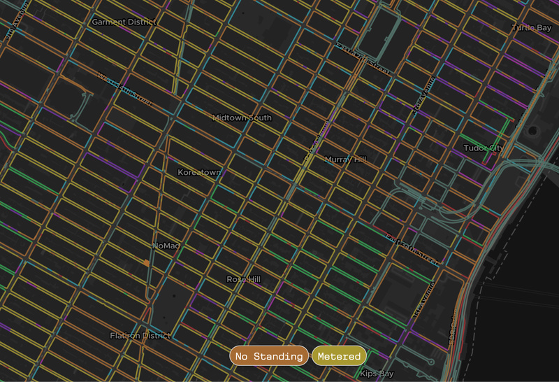
A design-forward interactive map by WXY Studio shows the parking rules along every stretch of curb in New York City!

Navigating New York City’s labyrinth of parking regulations can be time-consuming, frustrating, and expensive (if you disobey). More than 440,000 parking signs stand on sidewalks throughout the five boroughs, marking stretches of curb that might be affected by alternate side parking, taxi-only parking, truck loading, and a myriad of other restrictions. Using information from New York City’s OpenData program, the architecture, planning, and urban design studio WXY created a streamlined and easy-to-use interactive map that shows which regulations apply to which curb.
“As a studio we often need to understand the complex ways that New York’s curbs are used and regulated,” says Mario Giampieri, the WXY Associate who led the parking regulation map project, “We regularly use public data to identify various curbside uses, with recent examples including designing open spaces within the Meatpacking District and identifying optimal locations for curbside EV charging with NYC DOT.”
From EV charging stations and Open Restaurant sheds to pedestrian paths and parking spaces, many interests vie for space along the edge of New York City’s streets. “Through this work, we realized that a systematic look at curbside regulations would aid future initiatives to improve our public spaces,” Giampieri says.
The curb regulation map project started with parking sign data from the Sign Information Management System (SIMS). This system, updated monthly, lists the street where each sign is located, how far the sign is from a given intersection (as measured in the field when the sign is installed), and the text of the curb regulation printed on the sign. “By parsing this data we are able to generate accurate latitude and longitude coordinates for each sign, an improvement over the data as published in OpenData,” says Giampieri.
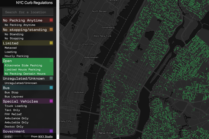
What also sets WXY’s map apart from the existing DOT Parking Sign map is that this data can be understood at a glance. A color key on the left side of the WXY map groups the city’s many different regulations into high-level categories that are each assigned a color. By clicking on a specific regulation in the key, you can instantly see the curbs it applies to highlighted in the assigned color on the map.
When you hover your mouse over a specific stretch of the curb, regulations that apply to that space appear at the bottom of the map screen. A search bar allows users to enter an address and see the specific regulations at that site.
“In the short-term, we hope [the map] allows users to visualize the current potential uses of New York’s curbs,” says Giampieri, “In the long-term, we are hoping to further develop this project into a tool that can be used to more effectively make decisions on curb management. We are still exploring what form that may ultimately take. Part of our hope in releasing this data is that it will generate ideas and conversations about how to use this information.” Explore the map here!
Next, check out The Floating Subway Map on a Sidewalk in SoHo
Subscribe to our newsletter
