Last Chance to Catch NYC's Holiday Notalgia Train
We met the voices of the NYC subway on our nostalgia ride this weekend!

New York as a multi-layered city
Cities are like creatures, dependent on the intricate systems providing them with life. A city’s buildings are therefore like organs where its life forces are housed. But absent the ability to interact with one another, these organs would be guaranteed to fail. Their success is predicated upon a series of connections, which become more complex the more that is required of them. New York City is known for its buildings, but without its labyrinth of roads and tracks those buildings could never have been built.
The turn of the twentieth century saw a plethora of architects, planners, and engineers dream of how they could facilitate New York City’s expansion. While some of them succeeded in bringing their designs to life, many of their greatest buildings and bridges never left the drawing board. In addition to buildings and bridges, numerous roadways and railways were developed to deal with the number of residents and commuters that overwhelmed the expanding city. In Part III of our series on “The New York that Never Was,” we will delve into the roadways and railways that were never realized. Some of these were never constructed because they were unrealistic, others were thrown by the way side due to red tape or funding issues, and still others were never constructed due to community opposition. Presented below are an array of different projects which never left the drawing board.
Alfred Speer developed the Railway Sidewalk, which he patented in 1871. It was designed to make a loop up and down Broadway freeing up space on the street for vehicles making deliveries and local stops. It is similar to the moving sidewalks which fascinate us at airports despite their slow speed. Speer’s sidewalk would have traveled at 12 miles an hour, which at the time would have been a substantial speed.
It is possible to see the heated mens’ smoking rooms ladies’ drawing rooms for women located on the inner ring:
In the March 1934 issue of Modern Mechanix and Invention, Alfred Albelli discussed the many benefits of filling in the Hudson River. A similar article had previously appeared in a January 1916 issue of Popular Science.
The article in full can be found here.
In December 1924, Popular Science Monthly reviewed a proposal by Dr. John A. Harriss, a former New York City health commissioner, to drain the East River as way to deal with the age-old congestion question. Harriss’ East River proposal would have also provided the city with a magnificent new city hall.
In 1931, a model of 1980 New York City was created for the film “Just Imagine.” The model, which adhered to the principles of engineering, displays nine layers of streets with nine lanes. If Hollywood had influenced New York City construction, imagine just trying to cross the street.
In 1924, Harvey Wiley Corbett, a noted New York City architect, proposed separating vehicular and pedestrian traffic with arcaded sidewalks. He thought that he would be creating “a modernized Venice, a city of arcades, piazzas and bridges, with canals for streets, only the canals will not be filled with water but with freely flowing motor traffic.”
In 1931, Corbett suggested dividing the into three levels, one for trains, one for cars, and one for pedestrians in order to relieve congestion.
Dr. John A Harriss called for a six story highway. In the futurism-filled world of 1930 it was thought to be one of the more practical ideas. It is interesting to note that Dr. Harriss was the special deputy police commissioner in charge of traffic in 1924 when he proposed filling in the East River. It appears that Dr. Harriss was fond of proposing vast changes to the landscape of New York.
A 1904 proposal to pedestrianize Nassau Street by turning it into an arcade:
Had this thoroughfare been constructed, a Robert Moses like roadway that would have sliced through Manhattan without regard for the neighborhoods already in existence. It would have started around Penn Station continuing north easterly to the Queensboro Bridge. The portion of the roadway from St. Patrick’s Cathedral to the bridge is depicted below:
In an alternative New York if you had traveled from Williamsburg to Bowling Green at the adrenaline rushing speed of five to nine miles it would have set you back one cent:
This underground moving sidewalk was first proposed in 1871, it was proposed again in 1902, 1910, and 1932 but never completed
In 1951, Goodyear Tire & Rubber Company and Stevens-Adamson Manufacturing proposed installing conveyor cars to shuttle passengers between Grand Central Station and Times Square:
The Dual Contracts of 1913, which were signed between the city and two private companies, called for the rehabilitation of many of the city’s existing subway lines and construction of new lines. One of these projects involved the BMT Fourth Avenue Subway line. The Contract called for the line to terminate in Staten Island. A tunnel across the Narrows would have connected Southern Brooklyn to Staten Island. Construction began on the line, but it was never completed. As one of the more realistic transit plans for the city it was returned to numerous times but, at least for the time being, is not being considered by the MTA. Maybe after the 2nd Avenue Subway is finally completed.
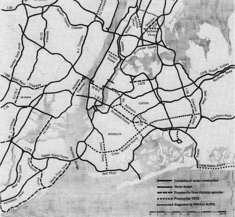
If Robert Moses had been a little more successful, New York would have looks a little more like this.
The Regional Plan Association’s 1964 map of proposed and existing roadways:

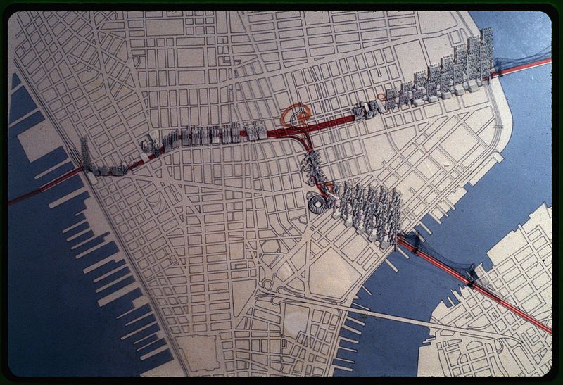
The Lower Manhattan Expressway (LOMEX) was part of Robert Moses’ re-envisioning the landscape of the city. In the 1960s, Moses proposed building an expressway to connect the Holland Tunnel, Williamsburg Bridge, and Brooklyn Bridge. Had Moses succeeded large swaths of lower Manhattan would have been destroyed. Community activists led by Jane Jacobs stopped the expressway from becoming a reality.
Renderings of the proposed Lower Manhattan Expressway:

Image via Library of Congress
The Mid-Manhattan Expressway was another one of the many expressways with which Robert Moses had planned to carve up Manhattan. The expressway would have connected the Lincoln Tunnel to the Queens Midtown Tunnel with a six lane elevated expressway across 30th Street. From its initial proposal in 1937 the expressway managed to stay on the drawing boards until it was finally dealt a deathblow by Governor Nelson Rockefeller in 1971.
Mid-Manhattan Expressway (proposed), looking east, circa 1959:
On the 50th Anniversary of Jane Jacobs’ Death and Life of Great American Cities, it is interesting to reflect how the competing visions of New York battled it out on the drawing board and in the board rooms.
Follow Untapped Cities on Twitter and Facebook.
The New York City that Never Was Series:
The New York City that Never Was: Part I Buildings
The New York City that Never Was: Part II Bridges
The New York City that Never Was: Part III Roadways and Railways
The New York City that Never Was: Part IV A Visionary Dream of the 1916 Zoning Resolution
The New York City that Never Was: Part V The New York Public Library
Subscribe to our newsletter