Last-Minute NYC Holiday Gift Guide 🎁
We’ve created a holiday gift guide with presents for the intrepid New Yorker that should arrive just in time—


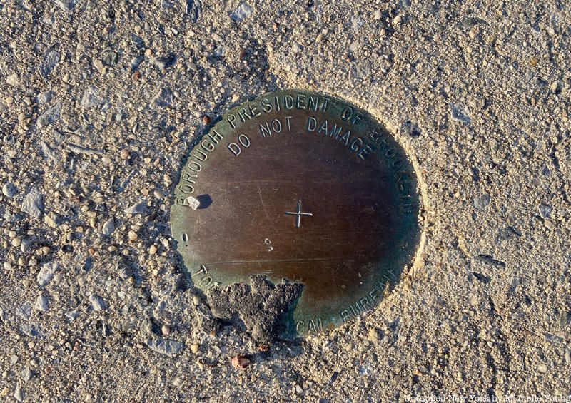
Have you ever come across one of these “topographical bureau” markers? If you’re a New York City nerd like us, you probably spend some of your time photographing things the ground — often to the consternation or bemusement of the people around you. It’s why we have such a large collection of manhole cover photographs, for example, that led us to create a podcast episode about them. And we’ve dug into the history of the property marker plaques.
One of other things embedded into the city’s streets and sidewalks we’ve been tracking for the last few years are these topographical bureau markers. They’re marked as belonging to the borough presidents of the city’s five boroughs with a “penalty for removal” warning. They resemble small manhole covers, about the width of a hand stretched. There are different versions of the marker, some with the latitude and longitude imprinted, others with a more severe warning that state “Imprisonment or fine for disturbing this mark.”

We reached out to both the office of Gale Brewer, Manhattan’s Borough President, and to Michael Miscione, the former Manhattan Borough President Historian. Miscione has been essential in keeping New York City’s quirky history alive, including promoting the legacy of Andrew Haswell Green, the unsung hero of Central Park’s design, and the celebration of the annual “Alligator in the Sewer Day.” He says of the topographical markers, “You’ll see them everywhere once you start to look for them; many are embedded in the sidewalk in little metal boxes with square tops. Surveyors call them benchmarks.”
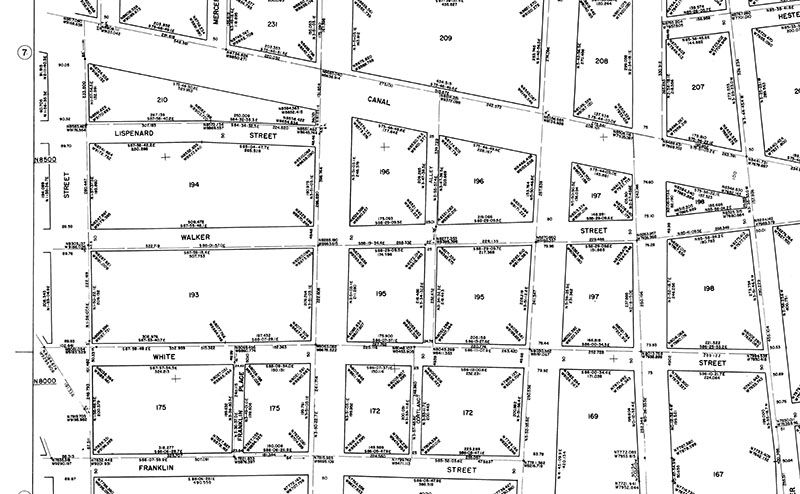
Aries Dela Cruz, Press Secretary, for Gale Brewer tells us “They are survey monuments within the bed of the street. The monuments are used be surveyors to determine street width and property line locations.” Cruz provided us with a survey map example, shown below, that provides information on this topographical bureau “monuments” or markers. Cruz continues explaining, “Surveyors will e-mail us [to] request for monument maps for the area they are surveying. They would use the survey map, legal alteration maps, and section maps, along with benchmark data to complete the survey.” You can find the topographical data from Manhattan, Brooklyn, the Bronx, Queens and Staten Island on the Borough President websites, and you can make appointments in each to visit their map rooms.

Miscione provided us with key historical background:
Since time immemorial municipalities (and private landholders) have needed to survey their territory so that they know the location of property lines, municipal boundaries, natural features, etc. Placing many permanent, immovable benchmarks whose locations are known with absolute certainty creates reference points that enable surveyors to easily set the sites for new nearby property lines, buildings, structures, etc. without referencing one master fixed reference point, like a scratch on the side of Bellevue Hospital — more on that later – which might be a very long distance away.
One of the duties of the borough presidents’ offices that has survived through the decades has been to track and oversee these benchmarks (and the official maps) for each respective borough. Each BP’s office has a Topographic Unit (names vary by borough, I think), usually consisting of a Borough Engineer and an overseer of the borough’s map collection.
During my tenure as MBH I made friends with the keeper of the Manhattan borough maps and would love spending time in the MBP map room. One thing I seem to recall is an old chart or diagram on the wall that mentioned a centuries-old scratch on the side of Bellevue Hospital as being the (or at least one of very few) master reference point from which the locations of all subsequent benchmarks were determined. It was like the great granddaddy benchmark for Manhattan!
Have you come across any of these topographical markers? For more on manhole covers, listen to our latest podcast episode!
Subscribe to our newsletter