Exclusive Gilded Age Arts Society Debuts New Public Exhibits in NYC
The American Academy of Arts and Letters, a venerable New York cultural institution, is a portal to art across time!


Welcome back to the Untapped Cities partnership with Gehl Institute in Copenhagen, looking at the impact of data, both open and collected, in the design of cities.
On March 7, New York City became the first local government to pass legislation ensuring public access to data. The passing of the bill symbolizes a political embrace of the “open” culture already underway in New York City’s “Silicon Alley.” City agencies and non-profit organizations in New York are making new correlations between urban conditions and social phenomenon, utilizing crowdsourcing and open data, to support traditional methods of data analysis.
Open Plans, a New York-based non-profit organization with a focus on transportation and urban planning, is an example of such a progressive group. The Open Plans team builds software which enables public agencies and non-profit organizations to crowdsource input from the community. You may recognize their work with New York City’s Department of Transportation’s interactive bike station suggestion map from this past year. In its decade of existence, Open Plans developed open source projects which include OpenGeo, Streetfilms, Streetsblog, GothamSchools, Civic Commons and OpenTripPlanner. According to the non-profit, all the tools serve to facilitate open source software, information transparency and progressive transportation planning.
Recently, Open Plans co-hosted a panel at the American Planning Association (APA) Conference in Los Angeles with Denver-based firm Place Matters, highlighting the challenges to come as we navigate amidst a constant and sometimes overwhelming flow of data. Important questions loom: How do we make sense of the data? With limited resources, should companies focus on making the quality of data better or the analysis tools better?
“I think we have a long way to go,” explained Frank Hebbert of Open Plans. “The majority of tools are broadcast tools.” Analysis of the increasingly amount of collected data remains difficult for the average resident, especially with the difficult program interface of GIS (Geographic Information System)–the industry standard. But with new online, open source mapping tools like MapBox, strides are being made–so much so that Hebbert announced to the chagrin of seasoned planners that desktop GIS was as good as dead, and that people shouldn’t waste any more time learning it.

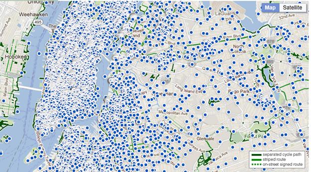
Publicly submitted requests for bike share stations in NYC
In partnership with Open Plans, the NYC Department of Transportation (NYCDOT) has also embraced this trend towards a more “open” culture by utilizing crowd-sourced information to plan station locations for the soon-to-be-launched Citibank bike share program. Bicycle commuting has increased in the city (35% from 2007 to 2008), but there are still significant challenges associated with bike ridership, including access. The collected crowd-sourced data, submitted via an interactive map on the NYCDOT website, allowed the public to suggest bike share stations for the rollout.

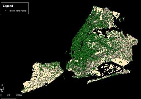
GIS map of bike share request points
However, one of the limitations of crowd sourced data is the input bias. Open source data cannot be used alone to determine bike share stations. The above represents the results of the publicly submitted bike share station requests. Untapped Cities’ Managing Editor Alley Lyles conducted a spatial analysis of the information.
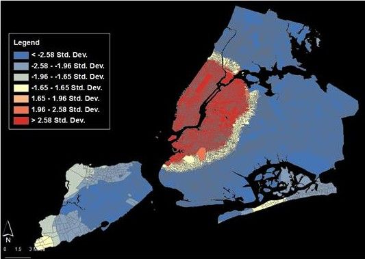
 On a city-wide level, the most requested bike share stations are in Manhattan, northern Brooklyn and western Queens.
The above hot spot analysis map indicates the significance of the NYCDOT data in terms of the most requested bike share stations. The most statistically significant requests (using a city-wide metric) are located in Manhattan, northern Brooklyn and western Queens.
To balance out the lack of data from underserved neighborhoods, the NYCDOT conducted participatory planning sessions around the city where residents could weigh in on where bike share stations would be necessary.
The case of bike share program is just one example of how real time feedback and data collection is influencing planning and informing design. It is also an example of the limitations of data collection. Much like the work of Charles Booth 150 years ago, as shown by Gehl Architects, it is necessary to combine and overlay a mixture of ethnographic, observational and spatial data in analysis.
Subscribe to our newsletter