Last-Minute NYC Holiday Gift Guide 🎁
We’ve created a holiday gift guide with presents for the intrepid New Yorker that should arrive just in time—


The idea of expanding New York City’s subway and rail systems would sound serendipitous to most New Yorkers. As of late, it seems as though we are constantly being blighted with train delays, signal malfunctions, fare hikes and overcrowded trains. The MTA reported that over 6 million riders rode the subway for a total of 29 consecutive days last year. At a time when daily ridership is increasing, New York City needs more rail options. Here are five potential and in-process rail lines proposed by some of New York City’s community activists, regional planning organizations and commuter rail organizations.

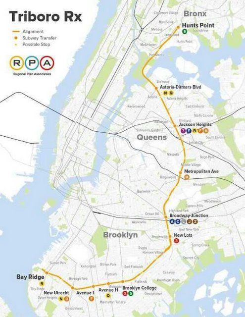
Map from Regional Plan Association
In 1996, the Regional Plan Association proposed a train line that would travel through Queens, Brooklyn and the Bronx . Also referred to as the “Triboro Overground,” the Triboro RX would comprise of 22 different stations that would run mostly above ground on rail lines that are currently being used by freight trains. Stretching from Bay Ridge in Brooklyn to the Cop-Op City section of the Bronx, the subway line would provide connections to the 2, 3, 5, 6,7, A, C, D, E, F, L, M, N and Q trains.
According to Capital New York, the proposed subway line would be approximately 24 miles and would serve around 100,000 riders weekly. The Regional Plan Association contends that the Triboro RX would be a solution to address “poor connectivity within and between the Bronx, Queens and Brooklyn, slow bus service, excessive transferring and service reliability.”
The proposed Triboro RX Line has some pros to it. Mainly, it would be built along an existing bed of railroad tracks therefore curbing any additional expenses that would be accrued if new tracks had to be built. However, with the impending inception of the Second Avenue Subway onto the city’s geography, as well as current construction of the East Side Access Project, finding money proves to be a huge barrier towards making the project a reality. Read about what some experts think about the Triboro RX in our recap from the Next New York series from the Forum of Urban Design

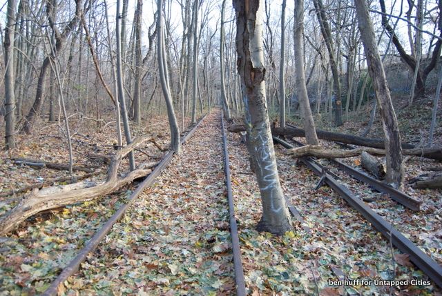
While there have been various proposals to transform the defunct Rockaway Beach Branch Rail Line into a new high line park called the Queensway, community activists have been calling for a new rail line to be built along the branch. Abandoned since 1962, the railway is a primarily elevated with a below grade portion to it. Stretching 3.5 miles from Rego Park to Ozone Park, the potential subway line along the Rockaway Beach Branch Rail Line would provide commuters with convenient transit options from Queens to Brooklyn. However, the notion of turining the abandoned rail into a walkway looks like it is taking shape. In December 2014, Governor Andrew Cuomo’s New York City Regional Economic Development Council awarded the Trust for Public Land with a grant totaling $443,750 to make the Queensway project a reality.
See a video of what the entire stretch of the proposed Queensway looks like now.
In 2014, Governor Andrew Cuomo discussed the idea of adding four additional Metro North stations in the Bronx and extending the commuter line to Penn Station as a way of bringing more alternative transit options to both boroughs. The four proposed new Metro North Stations would be built in the Co-Op City, Morris Park, Parkchester and Hunts Point sections of the Bronx along the New Haven Line. The proposed rail line would cross over the East River via the Hell Gate Bridge.
An expansion of the Metro North Railroad would be provide Bronx residents with a relatively easy commute to Penn Station. It would also improve access for residents of Co-op City who mainly rely on buses to gain access to rail systems. According to an article in The New York Times, the project, if executed, would cost more than $1 billion dollars. The project has gained interest from the likes of Bronx Borough president Ruben Diaz and governor Andrew Cuomo but is still far from reality.
Read also about 5 urban planning projects that could transform the Bronx.

With ridership among the Lexington Avenue Line (4,5,6 trains) at a staggering 1.3 million daily, the Second Avenue Subway would provide commuters with a convenient, and less overcrowded alternative to Manhattan’s East Side and beyond. The future subway line will consist of the rerouted Q train and newly designed T train which will run from the 125 Street – Lexington Avenue Subway Station to a newly designed station located at Hanover Square.
Since the late 1920s, a proposal for a subway line along the 2nd Avenue strip of Manhattan seemed more like a rumor than reality. As of late, it seems as those rumors have been finally put to rest. Phase 1 of the Second Avenue Subway Line, between 96th Street and 63rd Street, began construction in April 2007 and have cost $4.4 billion dollars. Phase 1 is projected to be completed around December 2016, but many feel this date is unlikely. Also, it was recently confirmed by MTA Chairman Thomas Prendergast that expanding the Second Avenue Subway beyond Phase 1 would be impossible currently due to the lack of funding.

The East Side Access project is currently one of the largest transportation infrastructure projects in America, according to the MTA. It’s designed to bring the Long Island Rail Road service to the East Side of Manhattan. The rail line will travel from Queens to Manhattan via the 63rd Street Tunnel where it will terminate at Grand Central Terminal. According to an article on Second Avenue Sagas, the completion date for the East Side Access Project is currently set between September 2020 and September 2023.
Whether you are a firm believer, optimist or transit cynic, the current state of these proposed rail lines only reaffirms the notion that providing New Yorkers with new rail service is a very protracted process.
Check out our behind the scenes photographs inside the construction of the Second Avenue Subway.
Subscribe to our newsletter