Last-Minute NYC Holiday Gift Guide 🎁
We’ve created a holiday gift guide with presents for the intrepid New Yorker that should arrive just in time—


Welcome to our new Weekly Map series, where we will highlight quirky urban maps, both vintage and present.
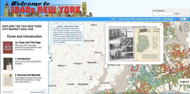
It’s hard not to love historical maps because beyond their geographic and demographic information, they also contain a window in time of information about the way society thought about their cities. A collection of maps and vintage photos based on the 1940 Census is available online at the fun website Welcome to 1940s New York, all sourced from a 1943 book “New York City Market Analysis” published by The New York Times, News Syndicate Co. (now The Daily News), The Daily Mirror and Hearst.
Steven Romalewski, director of City University of New York’s Urban Mapping Service, told us that he had come across the book by chance at the New York Bound Bookstore when it was going out of business in 1997, and then waited for the actual responses to the 1940 Census to be released to the public in 2010. The interactive map (which works on Safari and Firefox, but not Chrome) mixes vintage photos with demographic data. The website also shows demographic changes between 1940 and 2010. The entire book is scanned, and when you click on a neighborhood, the spread in the book shows up.
The book was designed as a “means to better sales planning and more resultful advertising” but it turned out to be also an incredible and endearingly intentional celebration of the rich diversity of the city. As they put it:
New York City is a city of contrasts. It is an amazing, infinite, inspiring, shocking, beautiful, old, new, city of seven million plus. Not so different, perhaps, from Main Street, but so much bigger, its contrasts so much stronger through sheer, overwhelming numbers.”
“The wealthy live beside the humble, and millionaires’ mansions back into bleak tenements. Lowest New York rentals discovered by investigators was a three-room flat on the Lower East Side for $12 a month. A few miles distant was a thirty-three room Sutton Place apartment renting for $18,000 a year. Somewhere in between lives the vast, unspectacular aggregate, the world’s wealthiest market.
In the below map, we see the Lower East Side at the very precipice of change. 40,000 Immigrants less than it had been ten years earlier with tiny pockets of expensive rentals (seen in red and orange), just after the first slum clearings.
The entire collection can be viewed at Welcome to 1940s New York. Get in touch with the author @youngzokeziah.
Subscribe to our newsletter