NYC by Air: Tracing the Geographical Evolution of the Modern City
NYC by Air: Tracing the Geographical Evolution of the Modern City
- March 29th
- 5 PM to 6 PM ET
- Webinar
- FREE for Insiders
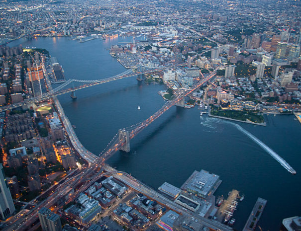
Join Rayn Riel, licensed tour guide, as he explores the five boroughs as they were in 1924, using high resolution aerial imagery available publicly from the NYC Department of City Planning.
- Clearly see all five boroughs from above 100 years ago in 1924, when the Woolworth Building was the tallest building in the world and the first aerial circumnavigation of the globe had just been completed.
- On Staten Island, find the 3 Staten Island Railway branches when today there remains only one.
- In Brooklyn, see old railroad lines not yet demolished, as well as Ebbets Field.
- In Queens, discover farmland and forests not yet developed and connected to the subway, and pristine wetlands still relatively untouched.
- In the Bronx, uncover intact neighborhoods not yet razed for highway construction.
- And in Manhattan, scope out Downtown, Midtown, Uptown, and see the borough when it had more people, more train lines, and wasn’t yet totally finished building out the original Penn Station and Grand Central Terminal complexes.


About the event:
Join us as we explore the five boroughs as they were in 1924, using high resolution aerial imagery available publicly from the NYC Department of City Planning. We will dive into the history of the city’s development, looking into infrastructure projects underway at the time and comparing the built environment of almost 100 year ago with today’s reality
Attendees will receive a link to join the webinar after completing the registration.
How do I sign up for this event?
If you are not an Insider yet, become an Insider today.
If you are an Untapped New York Insiders, simply login to your Insider account using the round icon in the bottom right corner of this screen. Once logged in, clock on the “Book Now” button to book this event for free!
Can’t login to your Insiders account?
Please make sure you are trying to sign in with the correct email address. If you have more than one email address please try logging in with all of them, that will solve this issue 99% of the time. Check out our FAQ for videos and more help documents.I registered already, how do I join the event?
After signing up for the event, you will receive an email with a link from Livestorm. Simply click on this link to join the event! Please check your junk mail if you can’t find your Livestorm link.
I missed the event, can I watch the replay?
Yes you can! Simply go to the Video Archive and stream over 100 past webinars, including this one. You will also get a link with the recording of the webinar as soon as it ends