
Secrets of NYC
Top 10 Hidden Beaches of NYC
From Great Kills, Staten Island to Soundview Park in the Bronx, discover secret beaches in NYC for a day in the sun!
From Great Kills, Staten Island to Soundview Park in the Bronx, discover secret beaches in NYC for a day in the sun!

Discover how vacant storefronts are being transformed with works of art!


Photo by Chris Torres
The May 2012 issue of Travel and Leisure magazine named LAX the 2nd worst airport in the United States. LAX took the lowest scores in almost all categories ranging from check-in to cleanliness to staff communication, revealing no surprises to those who frequent the airport. However, the one category that LAX ranked lowest that I find most interesting is ‘location’. It is a peculiar question to pose in a city as decentralized as Los Angeles, for how would one begin to chose which part of Los Angeles should be most connected to its airport. Despite multiple attempts to relocate LAX, it is clear that the airport will be a permanent social, economic and political fixture of the Westside of Los Angeles. In addition to these more fluid forces, LAX continues to have a strong spatial impact on the city. This impact on the space surrounding LAX has created voids in the urban fabric at a scale that is truly one of landscape, superseding the building lot, block and even neighborhood. This tour will bring you to two moments where the edge of urbanization and vacant urban space meet. To the casual tourist this edge condition greatly contributes to the lackluster experience of the airports location, however to others this same space reveals a unique insight into the spatial implications of development and the fantastical outcomes of urbanization.
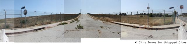
 A main entrance to the neighborhood formerly known as Surfridge
As the post WWII commercial boom of aviation forced LAX to expand, it soon began to rub up against long existing neighborhoods. Beginning in 1965 to 1979, LAX relocated 2000 residents and demolished over 800 homes on 430 acres of oceanfront land known as the neighborhood of Surfridge. The expansion of three runways put the flight path directly on top of Surfridge which was enough for the city of Los Angeles to practice eminent domain and acquire the property. For nearly 40 years the streets of Surfridge have sat empty with only crumbling foundations, rusting street signs and old streetlamps that until recently used to still come on at night.

Surfridge occupies the full west and northern edge of LAX
The rolling hills of Surfridge are mowed year-round and maintained as a butterfly sanctuary.

Many drought-tolerant species have survived, planted decades ago as specimen trees for single family residences.
The 2004 closure of 98th Street Elementary School signaled a milestone in the removal of residents of an area to the east of LAX near the 405 freeway known as Manchester Square. This 150 acre neighborhood cost the city of Los Angeles $485 million dollars to acquire as part of former mayor James Hahn’s vision to create an off-site check-in zone for the airport. The project has been put indefinitely on hold.

Curb-cuts and exotic trees mark the lots where houses recently stood
 Manchester Square is bordered by the 405 freeway, rental car lots and light industrial zones of LAX

The lack of residents has created a safe haven for people living in RV where informal colonies have emerged; sometimes up to 40 RVs park here semi-permanently
Also in 2004, the LAX Master Plan regarding the future development of LAX was approved by the City of Los Angeles. Under the Specific Plan Amendment Study (SPAS), potential alternatives to the projects previously analyzed as part of the LAX Master Plan Program are listed, which required further evaluation prior to implementation. These projects are therefore called “Yellow Light Projects” and are currently under 75-day public review. Of the nine alternatives, five incorporate Manchester Square (as “Off-Airport parking” or “Ground Transportation Center”); Surfridge shall remain abandoned, it seems.
Next, check out 10 of Downtown Los Angeles’ Most Architectural Sites.

Subscribe to our free newsletters
Free Newsletters
Get the best stories and things to do sent straight to your inbox.
