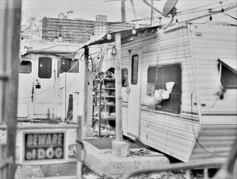
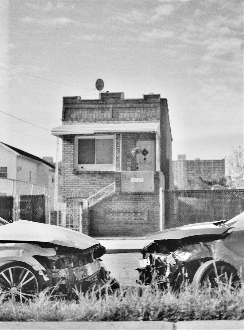
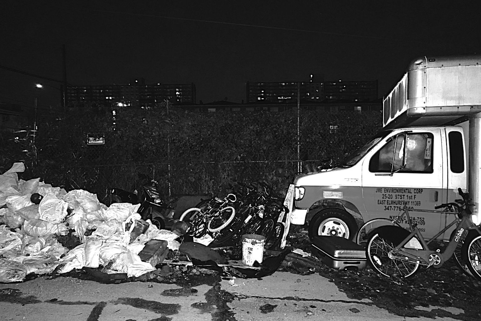
On a measly five-block triangular plot of land, nestled along the Brooklyn-Queens boundary line, sits one of the most fascinating yet mysterious places in the entire city: the Hole. The best word to describe it, if you had to pick one, might be “lost.” Partially flooded streets, vacant and overgrown lots, abandoned cars with bullet holes and shattered windows, motorhomes, numerous real estate signs, bulldozers, and even chickens transport you to what seems so much like “a frontier town in the Old West,” according to a New York Times article. Despite being just a turn off the busy Linden Boulevard, the neighborhood is eerily quiet. In some cases, maybe even a bit too quiet.
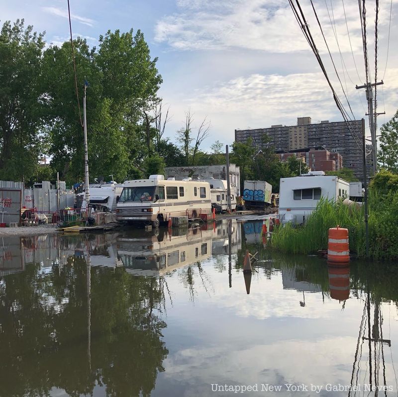
Venturing down one of the Jewel Streets (Emerald, Amber, Ruby, and Sapphire) will leave visitors without any doubts over why the neighborhood is even referred to as “the Hole.” Sharp declines in the roads lead you into a literal pit, one which is 30 feet below the average land grade. Getting around the massive pools of water collected on these streets is one of the biggest challenges facing the residents that live there. People usually keep rafts, kayaks, and even small boats outside their homes to navigate through the water, especially on stormy days.
Flooded intersection of 76th Street (Emerald Street) and Dumont Avenue
The Hole was most famously recognized as the site of an old mafia graveyard back in the early 1980s. Notorious Queens mob boss John Gotti and his crime family picked out certain spots in the neighborhood to dispose of their victims’ bodies. In 1981, a few children were playing on a vacant lot located on 78th Street (Ruby Street) between Blake and Dumont Avenues when they suddenly smelled something foul. After poking around in the dirt to see where the stench was coming from, they came across the hand of Bonanno crime family capo Alphonse “Sonny Red” Indelicato. Years later in 2004, the bodies of Philip “Philly Lucky” Giaccone and Dominick “Big Trin” Trinchera were dug up by the FBI on the very same lot thanks to a lead by an informant. What’s even more disturbing to consider is that these corpses are just a fraction of the many more that have been uncovered in the area.
The residents who have lived in the neighborhood for years have countless stories to tell. Those that settled here have stayed either because they have been unable to move anywhere else, are fugitives of the law, or just enjoy the isolation that comes with living in a place like this. It may have quite a distinct character and a certain mystique that is just baffling to anyone who has never heard of it before, but there is just something so strange about how neglected the place is that prompts serious questions. How could an officially registered neighborhood even get to such a state of abandonment? Why has it been so neglected? Who or what is to blame for it?
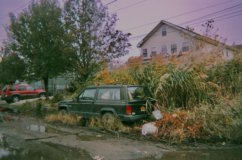
Residence in the Hole with an overgrown front yard. Photo courtesy of @schiaping.
Poor geology and topology
The combination of an unfortunate landscape and the marshy soil of South Queens has proven to be one of the main causes for the Hole’s drastic condition. The pools scattered around the community are a mixture of both rain and groundwater, meaning the area is so low-lying that the water table underground is closer to street level than usual. Because the water can neither drain into outlet pipes nor be soaked up by the wet soil, pools collect on the streets above.
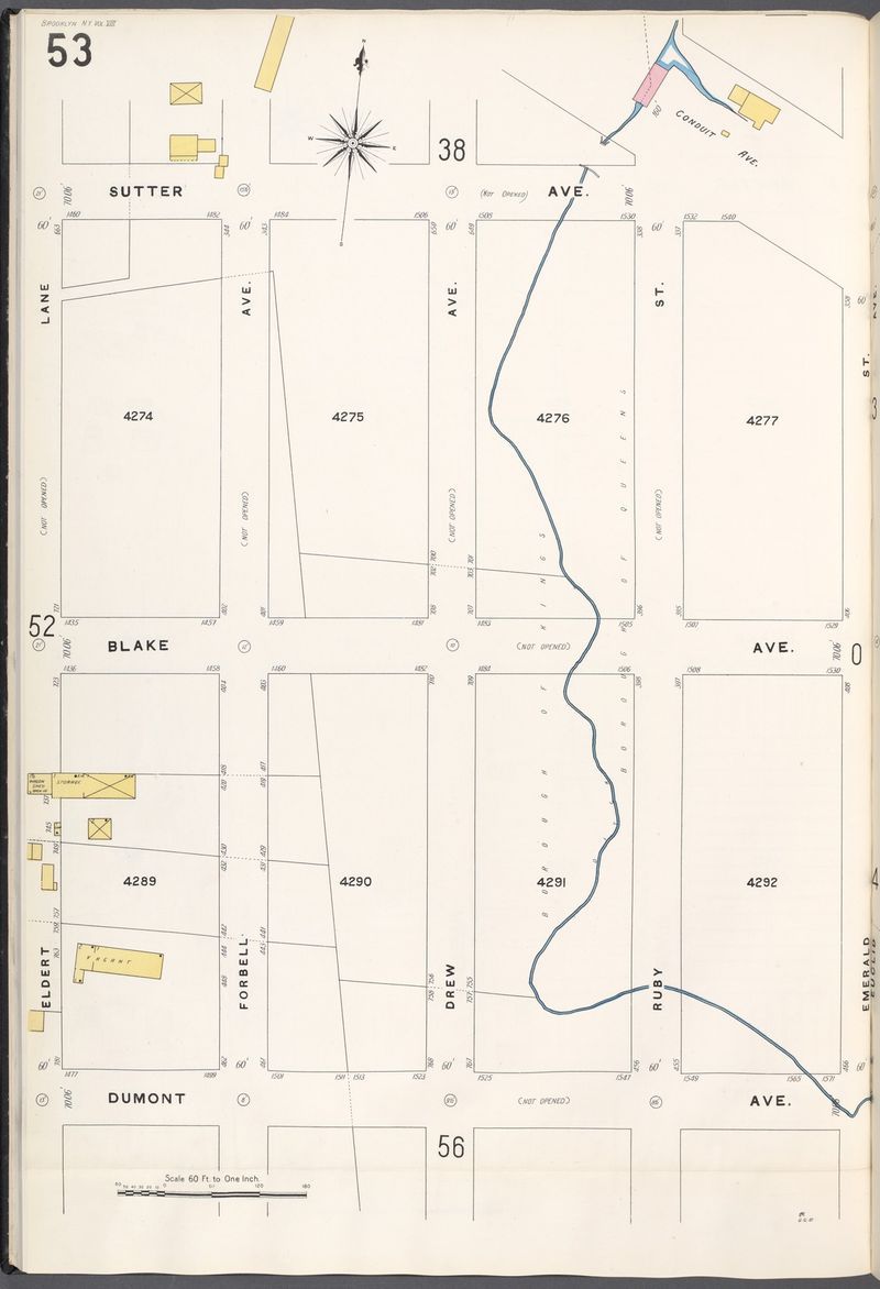
Understanding the source of all that moisture underground requires a look back at what the Hole was like more than a century ago. The property was owned by Jonathan Forbell and the Krats family, whose plot sat just east of the Elderts family farm. Both these names came to influence the street names that now run close to the neighborhood (Forbell Street and Elderts Lane). A small pond used to sit on the northern portion of the property with a stream that flowed south before opening up into the larger Spring Creek.
Map 1907 street plan of the Hole. Image via the New York Public Library‘s Digital Collections.
Homes in the neighborhood also are not connected to the city’s sewage system. These systems generally require gravity to help move the waste from housing units down into the ground below, but seeing that the Hole is level with what is normally considered “underground,” installing pipes beneath the streets would be pointless. Homeowners have to depend on cesspools and septic tanks to get rid of their waste, but even that presents its own complications. Most of the residents have had to rely on these same waste containers for decades since they could not afford to have them maintained or replaced. Because they have been in the ground for so long, many of them have ruptured, leaking waste into the soil around them. Putting two and two together, it’s fair to say that all those pools might consist of some extremely contaminated water.
Polluted soil in the Hole goes way back even before waste containers were installed underground. In the 1960s, much of the land from Spring Creek Basin up to South Conduit Avenue was mostly uninhabited. The city saw an opportunity to profit off this vacant land and proposed the construction of what was called a “Linear City.” The purpose of the project was to completely renovate the districts of South Central Brooklyn and Queens to provide for the rapidly increasing population in the rest of the city. Part of the renovation process involved the upgrading of sewage outlets to homes being developed around the proposed land for the Linear City. One upgrade involved the removal of an open sewage ditch alongside Ruby Street that contained a mixture of overflow from the existing sewage system. Therefore, contaminated soil had been present underneath the Hole for decades on end, later compounding with what would be excreted from expired waste containers.
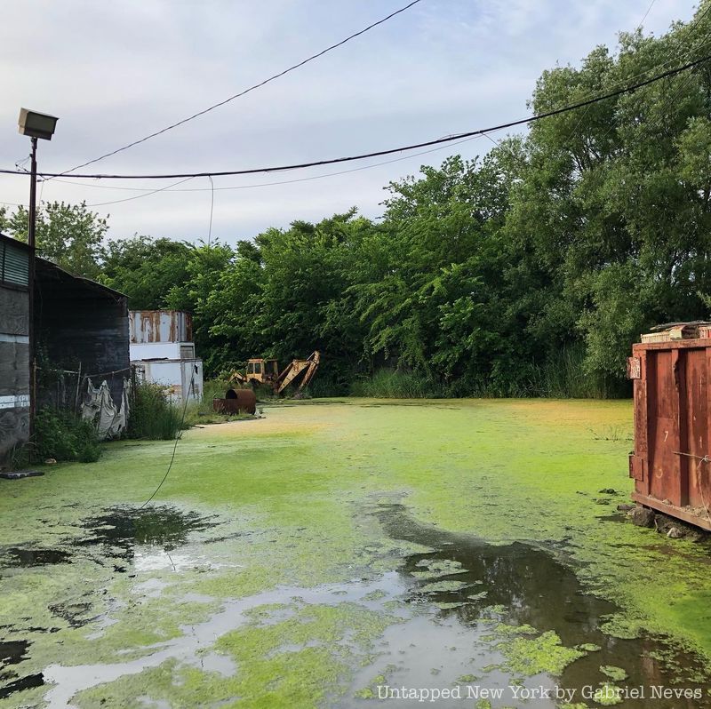
Pond covered with algae on the north side of the neighborhood featuring a rusty excavator
Unfortunately, these issues relate to the dozens upon dozens of real estate signs posted on many of the lots and fences in the Hole. Members of Community Board 10 in Queens and the Jewel Streets Community Block Association had been advocating for real estate developments in the area for years, specifically for projects with middle-class New Yorkers as their target market. One such proposal for the construction of a gated community called “Cobblestone Estates” was something that caused excitement in the neighborhood. However, the development ended abruptly and was soon abandoned after city officials stated that its property developers lacked the required permits to deal with contaminated soil in the area. Despite a desperate need for relief and repair, investors and real estate developers failed to see the need to purchase and renovate properties in the Hole because of how contaminated and dangerous the land actually is.
“Jurisdictional Ambiguity”
The phrase was coined by journalist Janon Fisher, who published an article on the FBI uncovering the bodies of “Philly Lucky” and “Big Trin” in the lot on 78th Street back in 2004. She mentioned in her piece how the NYPD patrolled the neighborhood and played a role in maintaining the safety and ordinance of the Hole. What correlates directly with this is the way the area is split up on a map.
The Hole is divided into two uneven sections by the Brooklyn-Queens county line, meaning that each portion of the neighborhood falls under the protection of two separate police precincts (75th of East New York and 106th of Ozone Park). The ambiguity lies in the way officers between the two sectors collaborate to patrol the area. It is almost as if one unit leaves its responsibility to the other apart from joint operations, which primarily include the towing of abandoned or stolen vehicles.
The desire to maintain a presence in the neighborhood seems to have been neglected over the years. Each precinct has a designated duo of officers for each sector within their unit known as NCOs (neighborhood coordination officers). These individuals are responsible for cultivating an integral relationship between the police department and the citizens of each community. It has proven to be difficult for the 75th and 106th precinct NCOs to establish themselves in the Hole because, for one, some streets are completely inaccessible either because they are flooded or in poor condition. Secondly, the place is isolated and largely uninhabited when compared to the neighborhoods around it, leading the prospect of community building overlooked.
Delay in government support
The reason why the city’s major departments have not stepped up efforts to support and renovate the community in the Hole remains a multi-decades-long mystery. In the 1990s, the Department of Environmental Protection discussed connecting the neighborhood to the rest of the city’s sewer system. Installing new piping would have required the entire area to be raised so that waste can adequately flow, but despite proposals, work never really commenced. The departments of Environmental Protection and Transportation would frequently send over surveyors to inspect the land and respond to residents’ complaints, but even so, no progress was ever made.
Inaccessibility, as seen with NYPD vehicles being unable to patrol certain streets in the neighborhood, is an issue that poses a cause for concern. Unpaved streets and pothole-ridden asphalt make it difficult for emergency vehicles such as fire trucks and ambulances to reach certain housing units. This same problem also applies to the system of street plowing done by the Department of Sanitation during winter storms. Officials in the past have addressed the department’s irregularity in clearing up the neighborhood’s streets by referring to the prioritization system followed for street clearing. The agency salts and plows the most important roadways first so that emergency vehicles can access them. Heavily traveled roads come second, and tertiary streets, which are either dead ends or side streets, are last on the priority list. Being that the Hole consists almost entirely of tertiary streets, sanitation trucks often bypass it. This has forced residents over the years to rely on their own equipment (bulldozers, snow blowers, etc) to remove snow and ice accumulations.
In 2013, the Department of Transportation made an official statement to Community Board 10 members discussing a long-term construction project that would be set to begin in 2024. The “Jewel Street Project” would cost around $50 million and would involve raising the neighborhood grade, repaving the roads, installing a newly improved storm drainage system, and reconnecting the Hole to the city’s sewer network. The renovation would of course include the streets of the Hole, but it would also involve the land south of Linden Boulevard in Lindenwood where residents experience similar flooding and drainage issues.
It remains to be seen whether or not the city will truly follow up with this plan. Despite the hope and relief that would be expected from this kind of rezoning project, some important questions remain. What’s going to happen to the handful of residents that live in the neighborhood? Will they have to move away and find someplace else to live? What about their homes and belongings? There is still a degree of uncertainty in the community about what is truly going to happen, but what is undeniable is that this issue has been present and unresolved for far too long.