

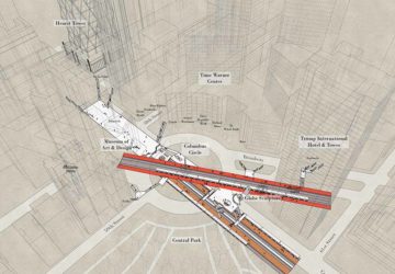
"X-Ray Area Maps" of NYC subway stations show five complex stations – Times Square, Herald Square, Union Square – in the context of their surroundings.
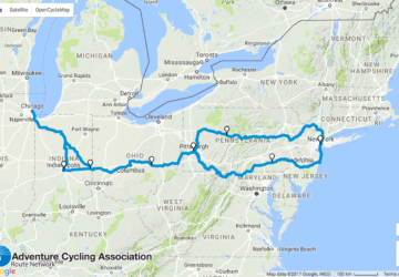
A cool interactive map details a bike route over 1,100 miles long that goes through forests, valleys, and other terrain from Chicago to New York City.
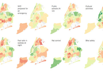
Thanks to some extensive reporting by the New York Times, opinions regarding 44 different urban living scenarios have been aggregated in a city-wide survey.
A new, interactive tool, developed by the Buildings Department, tracks an ever-present fixture in New York City: scaffolding, also known the "sidewalk shed."

Maps are an important part of the Museum of the City of New York's exhibit about NYC's 400 years of history, New York at Its Core – a must-visit.
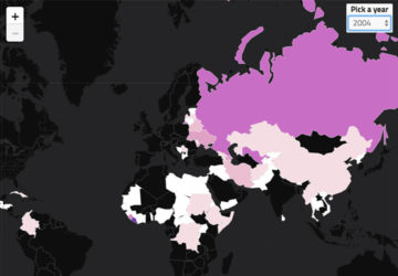
A map shows where the refugees who entered through NYC come from around the world. The U.S. has accepted 8,066 refugees through NYC since 2002, after 9/11.

11 large-format intricately detailed Diorama Maps by Japanese artist Sohei Nishino are on view at the Bryce Wolkowitz Gallery exhibit Sohei Nishino: Bricolage.

Katharine Harmon maps out 400 years of NYC history in this collection of 200 maps charting every representation of the five boroughs' past, present and future.
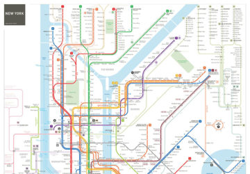
Jug Cerovic created his own rendition of the NYC subway map, and after some feedback, he's added final touches, including a more accurate depiction of Brooklyn.
NYC Parks Department has spent over a year gathering data for the Treescount! census. With help from volunteers, park officials also created a Street Tree Map.